Dry stretch and drought to continue in central, eastern US

While parts of the mid-Atlantic and Northeast had some high clouds from the outer fringes of former Hurricane Imelda earlier this week, no precipitation fell north of Washington, D.C. With high pressure taking control of the pattern, dry weather will continue through the remainder of the weekend.

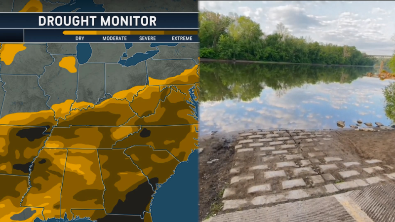
For many locations in the Northeast, this dry weather began in August. Even though places like Chicago had rainfall above the historical average in August, only 15% of the historical average fell in September. This has caused expansive drought across much of both the Midwest and Northeast. Other locations also had a notably dry September as well.
"The lack of rain pushed several cities into the top 10 driest Septembers on record. St. Louis had it eighth driest September on record; Cleveland has its second driest; and Beckley, West Virginia, had its fourth driest," highlighted Merrill.
Not only is the dry weather intensifying the drought, but it is also affecting agriculture.
"Farmers in the Greenbrier Valley of West Virginia are being adversely impacted by the drought," said AccuWeather Senior Meteorologist Chad Merrill. "One farmer had to sell lamb early because the pastures are too short."

Some much-needed rain did fall in the Northeast last week. While there were some short-term benefits, they were limited.
"Although parts of New York, Pennsylvania and northern West Virginia had 1-3 inches of rain last week, farmers indicated that most of the moisture was runoff and did not help to rejuvenate creeks, ponds or the soil," noted Merrill.
As the drought has continued to grow in length and intensity, other impacts are beginning to become apparent.
"Soil moisture is severely depleted in the Northeast, and ground water at a measuring station in southern Vermont is near a record low level," said Merrill.
Merrill went on to say that it would take another 3 to 6 inches of rain in the Northeast to catch up to the historical average.
Frosty starts to Thursday and Friday, but warmer weather is ahead
With a clear sky and calm wind combined with the dry ground, there were temperatures in the 30s and patchy frost in parts of the interior Northeast on both Thursday and Friday mornings.
Temperatures were also a bit below the historical average for daytime highs on Thursday. As high pressure begins to shift offshore through the weekend, high temperatures will return to levels above the historical average.
Abundant sunshine and the dry ground will continue to be contributing factors to rising temperatures. Although the sun angle is getting lower as we head toward winter, the sun's energy is able to go into heating the dry ground instead of evaporating moisture.
Chilly mornings will not be a theme farther west, and some record highs may even be challenged.

The summerlike warmth will last through Sunday. After that, it does appear that much cooler air will move into the region. Unfortunately, only locations in the Dakotas and northern Minnesota may receive beneficial rain. There is the potential for some rain along the cold front farther east, but any rain is expected to be short-lived and progressive and do little to alleviate the drought.
Report a Typo