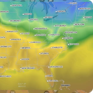
...EXTREME COLD WARNING REMAINS IN EFFECT UNTIL 6 AM AKST WEDNESDAY... ...HIGH WIND WARNING REMAINS IN EFFECT UNTIL 6 AM AKST WEDNESDAY... * WHAT...For the High Wind Warning, northeast winds 25 to 35 mph with gusts up to 60 mph. For the Extreme Cold Warning, extremely cold wind chill temperatures as low as 50 below. * WHERE...Municipality of Skagway. * WHEN...Until 6 AM AKST Wednesday. * IMPACTS...High winds will blow around unsecured objects and may damage property and cause power outages. Travel will be difficult. Frostbite and hypothermia are likely if exposed to these temperatures. An extended period of freezing temperatures could cause ruptured water pipes. * ADDITIONAL DETAILS...Coldest wind chills will be on the Klondike Highway near White Pass. Near Skagway and Dyea, wind chills will be down to 30 below. PRECAUTIONARY/PREPAREDNESS ACTIONS... People are urged to secure vessels and loose objects that could be blown around or damaged by the wind. Report any damage to the National Weather Service by visiting weather.gov/Juneau/StormReports Wear protective clothing such as a hat, facemask and heavy gloves or mittens if you have plans to be outdoors. To prevent freezing and possible bursting of outdoor water pipes they should be wrapped, drained, or allowed to drip slowly. Those that have in- ground sprinkler systems should drain them and cover above-ground pipes to protect them from freezing. &&
Extreme Cold Warning
Source: U.S. National Weather Service
Start
6:00 PM
Thursday, December 18
End
6:00 AM
Wednesday, December 24