Dangerous storm to flood California, threatening lives and property before Christmas
Flash flooding and mudslide risks continue in Northern California and will rise in Southern California through Christmas Day as heavy snow blocks Sierra Nevada roads.
An influx of moisture from the deep Pacific combined with cold air originating from Alaska is expected to trigger flooding across parts of California, while higher elevations may face heavy snow accumulations.
A strengthening storm off the West Coast will create yet another atmospheric river to pump copious amounts of rain from the Pacific Ocean to much of California through Christmas Day, potentially creating life-threatening flooding and mudslides.
Heavy rain will create a significant risk to lives and property in some areas. Feet of snow in the Sierra Nevada may not only close some roads but could also leave people stranded.

Multiple inches of rain will pour down over a few hours, on the mountainsides and in urban areas of California. Those in the coastal regions of Southern California will receive multiple months' worth of rain in a span of one to three days.

"The downtown Los Angeles area is projected to receive 4-8 inches of rain through this week alone which is two to three times the entire December historical average rainfall of 2.48 inches," AccuWeather Senior Meteorologist Tyler Roys said.
Some of the heaviest rain will unfold while people are asleep.
"The heaviest rain for Los Angeles is likely to fall from late Tuesday night through Wednesday," AccuWeather Chief On-Air Meteorologist Bernie Rayno said. "Driving around L.A. during the height of the storm, especially Wednesday morning, could be especially dangerous."
Rainfall rates during this time could reach 2 inches per hour, which can overwhelm storm drains and cause streets to turn into ponds and rivers. The historical average rainfall for all of December for Downtown Los Angeles is 2.48 inches.

Some of the west- and southwest-facing mountain slopes of the Transverse Ranges in Southern California will receive up to a foot of rain, with an AccuWeather Local StormMax™ of 16 inches, leading to tremendous and rapid runoff.
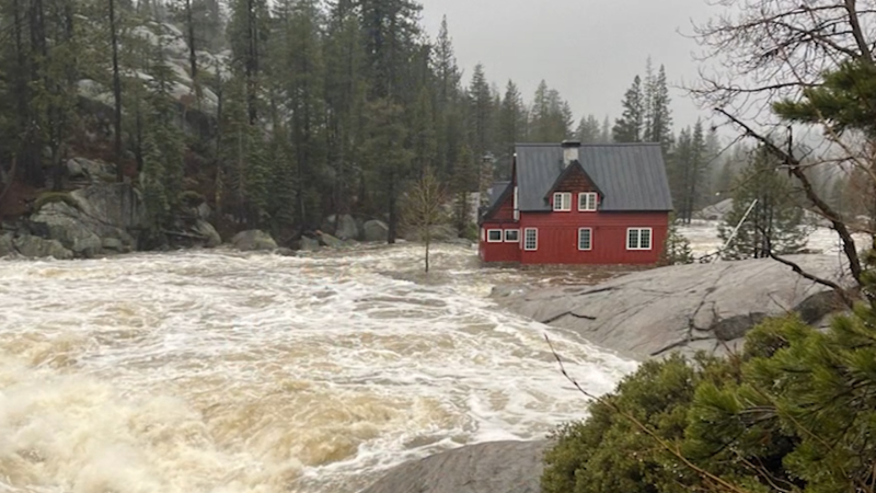
The heavy rain expected across Northern, Central and Southern California for much of this week could turn small streams into dangerous rivers, send fast-moving water across roads and even wash out some highways. As the ground becomes soaked, the risk of mudslides will increase significantly.

"The fast-moving runoff can pick up rocks, mud, ash and debris, quickly turning into a debris flow that can race down hill with little warning, taking out homes, vehicles and roads along the way," AccuWeather Meteorologist Brandon Buckingham said.
Debris flows may be most common in recent wildfire burn scar locations, including the January Palisades and Eaton wildfires.
Downpours will reach the high and low deserts in California and part of the Great Basin in the southwestern United States. There will be a risk of flash urban flooding in Las Vegas from Wednesday to Friday.

Heavy snow to create dangerous travel in Sierra Nevada
"Feet of snow will pile up on the Sierra Nevada this week with many of the ridges and peaks in the region picking up 8-12 feet of snow and some places perhaps picking up 15 feet," Rayno said.
Snow will reach lower elevations in the Sierra Nevada this week, dropping to the mountain passes by Wednesday night, and may drop to 5,000 feet for Christmas.
"At Donner Pass, California, along the heavily-traveled Interstate 80, from 2 to 4 feet of snow is forecast, beginning in earnest Wednesday night and continuing through Christmas Day and into Friday," Roys said.
Some roads, including Interstate 80, may be closed temporarily.

The snow will be a boon for the ski resorts and a future source of water during spring runoff, but with prolonged and heavy snowfall, some people traveling to and from the resorts may become stranded.
Airline delays anticipated
"Air travel through major hubs, including Los Angeles, San Francisco and Sacramento, California, could face delays due to strong winds, reduced visibility and runway flooding," Roys said.
Substantial flight delays and cancellations are possible.

High winds could cut power
Wind gusts of 40-60 mph are another threat from this storm, which can break tree limbs and lead to power outages.
Some of the strongest wind gusts of 60-80 mph will occur in the Sierra Nevada, the northern coast of California and around Mount Shasta. The AccuWeather Local StormMax™ of 130 mph is most likely in the mountains.

With this potent system, some local thunderstorm activity can't be ruled out, with the potential for hail and possibly a couple of tornadoes or waterspouts.
Still damp to end the week
Later in the week, from Friday to Saturday, the intensity of the storm will begin to ease, but chilly air will be in place and moisture will linger.

By the end of the week, snow may fall on the passes in Southern California along I-5 and I-15, resulting in slippery travel.
Want next-level safety, ad-free? Unlock advanced, hyperlocal severe weather alerts when you subscribe to Premium+ on the AccuWeather app. AccuWeather Alerts™ are prompted by our expert meteorologists who monitor and analyze dangerous weather risks 24/7 to keep you and your family safer.
Report a Typo


