Robust, severe storms to spark flooding concerns, travel delays late week
AccuWeather meteorologists warn that a dangerous setup can unfold later this week across the central and southern U.S., which will bring the threat of large hail, strong winds, flooding downpours and even a few tornadoes.
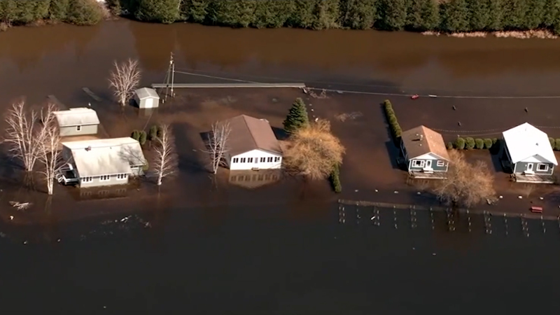
Tornado-warned severe storms swept across the southeastern region of the United States on March 9. The storms left behind damage in its wake, which included flooding in Alabama and South Carolina.
Spring air, dry weather and a warm breeze will be the theme early this week across the South and portions of the Plains, AccuWeather meteorologists say. However, a dangerous severe weather threat will lurk later in the week and break the pleasant pattern.
Warm air pumping into the Plains
A zone of high pressure anchored over the South Central and southeastern states during the first half of the week will grip the region, pumping warmth into the central and eastern portions of the country.
Breaks of sunshine and daytime highs soaring into the upper 60s and 70s Fahrenheit from central Texas to southern Wisconsin will be the theme at the start of the week, but temperatures will rise into the 80s and even crest the 90s in southern Texas by Wednesday.

On the westernmost fringes of the area of high pressure, conditions will become rather breezy across the Plains into midweek. Storm activity will begin to ramp by Tuesday night as pockets of strong thunderstorms pop up across northeastern Oklahoma, northwest Arkansas into Missouri.
The threat for damaging wind gusts, large hail and even tornadoes can continue into Wednesday across northern Kansas, southeastern Nebraska and Missouri, where thunderstorms can become severe by the afternoon and evening.

By Thursday and Thursday night, a dynamic threat will begin to unfold for residents across the Plains and Mississippi Valley as a storm advances across the center of the country.
Severe storms to spawn on Thursday
"As a potent storm moves eastward into the southern Plains and lower Mississippi Valley later Thursday into Thursday night, it will tap into a warm, moist and unstable air mass in place across the region," explained AccuWeather Senior Meteorologist Dan Pydynowski.
Pydynowski added that this pattern will set the stage for a dangerous severe weather outbreak that can stretch from Austin, Texas and the Dallas-Fort Worth Metroplex all the way to St. Louis, Missouri; Paducah, Kentucky; and Evansville, Indiana, by Thursday night.

The center of the storm will push eastward into the Ohio Valley throughout the day Thursday, with a cold front trailing across the Mississippi Valley into Texas. Heavy rain and robust thunderstorms are projected to develop ahead of the boundary, soaking areas from Oklahoma to the Southeast coast from Thursday to Friday evening.
Although rain will reach locations around the Midwest by Thursday morning, thunderstorms are expected to hold off across this region until midday Thursday. By the afternoon hours, storms will be capable of producing flooding downpours, large hail, damaging winds and isolated tornadoes as they roll across the region. Severe thunderstorms can pack winds of 50-60 mph from Thursday afternoon to Thursday night with the AccuWeather Local StormMax™ of 75 mph.
As the cold front travels across the South Central states, severe thunderstorms can develop as early as Thursday morning from central Texas to Oklahoma, with similar threats. The storms will move eastward into the Mississippi Valley as the day continues.
Have the app? Unlock AccuWeather Alerts™ with Premium+
"The storms that move eastward into the lower and mid Mississippi Valleys and lower Ohio Valley will be of particular concern because they will likely occur after dark Thursday night when people may be sleeping and not be able to see or be aware of an approaching tornado. Having a NOAA weather radio and alerts enabled on your AccuWeather app are of critical importance in these areas," highlighted Pydynowski.

In addition to the potential severe weather outbreak Thursday afternoon and Thursday night, there will be a flash flood risk across a large portion of the southern U.S. Thursday and Friday from this expansive storm, Pydynowski explained.
Swollen rivers, localized flooding possible
Later this week, between 1-3 inches of rain will be possible across the southern states, some of which have already been inundated with heavy rainfall at the end of the previous week. To date this year, cities such as Memphis, Tennessee, Little Rock, Arkansas, and Jackson, Mississippi, are running above the historical average in terms of rainfall.
Additional rainfall this week could quickly lead to localized flooding across the Mississippi Valley watershed.
"Copious amounts of moisture available from the Gulf of Mexico will help to produce rounds of heavy rainfall Thursday into Friday from eastern Texas eastward to Georgia and the Carolinas. Travel along Interstate 20 these days could be made very difficult with standing water possible at times as well as downpours which can greatly reduce drivers’ visibility," pointed out Pydynowski.
Another round of rain and even thunderstorms may be possible across the Gulf Coast states by the upcoming weekend, forecasters say.
Want next-level safety, ad-free? Unlock advanced, hyperlocal severe weather alerts when you subscribe to Premium+ on the AccuWeather app. AccuWeather Alerts™ are prompted by our expert meteorologists who monitor and analyze dangerous weather risks 24/7 to keep you and your family safer.
Report a Typo


