After weekend lull, dangerous storms to refire in central US starting Monday
The thunderstorms, which will span dozens of states through Thursday, could pack damaging wind gusts, hail and even a tornado or two.
Softball-sized hail struck Aurora, Missouri, during a severe storm on April 28, damaging vehicles and breaking apart on impact. The National Weather Service warned of large hail and strong winds.
Following days of severe weather across the nation's midsection and South dating back to late April, cooler, drier air will put a lid on thunderstorm activity through the weekend. AccuWeather meteorologists warn that the lull will not last long, though.
A new multiday severe weather event will kick off Monday in the Plains before expanding east and south later in the week. Initially, a cold front will be responsible for the potent thunderstorms, but eventually, a stronger storm moving along that front will amplify the threat for damaging weather.

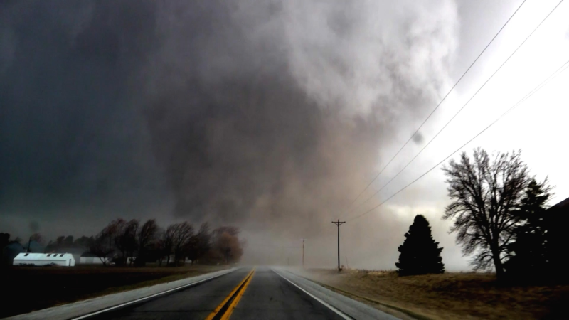
Storm clouds form over a public park as thunderstorms approach the region, Saturday, April 25, 2026, in Plano, Texas. (AP Photo/Tony Gutierrez)
"Tuesday and Wednesday appear to be the most volatile days in terms of severe weather, including the risk for a few tornadoes from eastern Oklahoma and Texas into Mississippi," warned AccuWeather Senior Meteorologist Adam Douty.
While the widespread nature of the severe weather from last week is not expected to be repeated this week, the risk posed by these thunderstorms to cause damage should not be dismissed.
Severe risk returns on Monday in Midwest
After a widespread frost and freeze event just days prior, the Midwest will be the first to be under the risk of severe storms come the start of the workweek, say AccuWeather meteorologists.

A cold front sweeping south from northern portions of the Plains, bringing the next round of cooler air from Canada, will clash with warmer air in place from central portions of the Plains into the Midwest on Monday afternoon. The result will be thunderstorms that could pack at least downpours, lightning and perhaps even localized damaging winds and hail.
Millions will be at risk into the evening, including those in the metropolitan areas of Chicago, Cincinnati, Indianapolis, St. Louis and Kansas City, Missouri.
GET THE FREE ACCUWEATHER APP
•Have the app? Unlock AccuWeather Alerts™ with Premium+
O'Hare International Airport, the busiest airport in the world, could be impacted, which would have a ripple effect at other major hubs. Travelers into and out of Des Moines International and Eppley Airfield in Omaha, Nebraska, among many other airports, could also face delays and cancellations.
While some severe thunderstorms could produce tornadoes, that risk appears to be low on Monday, since winds in the atmosphere will not be changing much with height. That will likely change beginning the next day, though.
Tornado risk farther south Tuesday and Wednesday
Since late April, dozens of tornadoes have been confirmed across the United States, from Nebraska to West Virginia, with recent rounds of severe weather. The risk for a few twisters will return from Tuesday afternoon through Wednesday, warn AccuWeather meteorologists.

"The tornado risk may persist into the night each day, as well," warned Douty. "This can make for an especially dangerous situation with people sometimes not seeing warnings as they sleep."
Having a reliable source to receive warnings, especially at night, is critical in the severe weather threat area. The AccuWeather app offers this service.
The same high-altitude storm bringing chilly rain and mountain snow showers to the West and Rockies will be the impetus for severe thunderstorm development come Tuesday from Texas north and east through southeastern Oklahoma, western Arkansas and far southern Missouri.

The Dallas-Fort Worth Metroplex, which was hit multiple times by storms containing large hail and tornadoes just days ago, is near the center of the "some" risk area issued by AccuWeather meteorologists for Tuesday afternoon and night. It extends all the way from near the border with Mexico to the Ozarks.
In addition to the chance for a tornado or two, storms could also pack hail and damaging wind gusts.

By Wednesday and Wednesday night, a portion of the lower Mississippi Valley and Southeast will get in on the action as the storm works east. While Houston and New Orleans will be near the edge of the severe weather threat area, cities such as Baton Rouge, Louisiana; Jackson, Mississippi; and Birmingham, Alabama, will be in the middle of it.
As more people start to head outdoors with summer just around the corner, those vulnerable to the dangers of thunderstorms should be prepared to seek shelter at a moment's notice.
Gusty storms could reach I-95 later in the week
The chance for severe thunderstorms will reach into a fourth and likely final day on Thursday as the front from earlier in the week, combined with the storm from the Plains and South, arrives along the Eastern Seaboard.

Tens of millions of people along the Interstate 95 corridor from Georgia north to central Virginia are currently in AccuWeather's "some" risk for severe storms that day. It appears flooding downpours and damaging wind gusts over 50 mph are the biggest threats.
Outdoor baseball games in Washington during the afternoon and Philadelphia during the evening could be delayed or postponed due to the threat of rain.

Farther inland across the Northeast, an area of chilly rain is expected to fall with even the prospect of a few snowflakes mixing in across the higher elevations of the Adirondacks and northern New England by night.
The same cool air bringing rain and the threat of very late-season snow to parts of the Northeast will effectively end the severe weather threat on Friday as cool breezes return up and down the East Coast after a warm week.
Want next-level safety, ad-free? Unlock advanced, hyperlocal severe weather alerts when you subscribe to Premium+ on the AccuWeather app. AccuWeather Alerts™ are prompted by our expert meteorologists who monitor and analyze dangerous weather risks 24/7 to keep you and your family safer.
Report a Typo