Pattern change to bring brief relief to Northeast
By
Mary Gilbert, AccuWeather meteorologist
Published Jul 18, 2021 11:21 AM EDT
|
Updated Jul 20, 2021 1:34 PM EDT
Following a week of above-average temperatures, high humidity and drenching storms, AccuWeather forecasters say those residents hoping for a break in the heat, humidity and storminess will have their wish granted, although only to a limited extent.
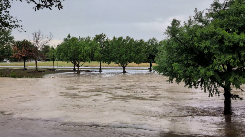
A drenching week across much of the northeastern United States was bookended as feisty thunderstorms tore across the East on Saturday. These storms unleashed damaging wind gusts and flooding rainfall from North Carolina to southern New England.
Tree branches were snapped and debris from damaged trees overspread roadways. In addition, some power lines were brought down and buildings were damaged.
An impressive wind gust of 78 mph was recorded a few miles northwest of Cape May Point, New Jersey.
AccuWeather forecasters say brief relief is on the way for waterlogged portions of the Northeast, courtesy of a slight change in the atmospheric pattern.
For the past week or two, a pronounced dip in the jet stream worked to drive deep, moist air from the Gulf of Mexico up into the Northeastern states. Now, the jet stream has lifted northward and cut off the deepest supply of moisture to the region.
This led to fairly dry weather to begin the week with only isolated thunderstorms across the interior. The sky was not completely clear, however, as smoke from wildfires in western North America caused a hazy sky.
On this image captured around noon on Monday, July 19, 2021, clouds were visible as bright white, while smoke from wildfires in western North America were evident as a wispy white or gray color. (CIRA at Colorado State/GOES-East)
Along with a reduction in overall moisture, temperatures have begun to level off, creeping back to near-normal levels.
"The area is catching a break from the recent stretch of warm weather thanks to slightly cooler air from the west-northwest," AccuWeather Meteorologist Adam Sadvary explained.
CLICK HERE FOR THE FREE ACCUWEATHER APP
This cooler air arrived for many as early as Sunday. Cities like Harrisburg and Allentown, Pennsylvania, where temperatures topped out in the lower 90s on Saturday, were in the upper 70s on Sunday.
"Temperatures should overall hold steady around the seasonal normal for the majority of the week," Sadvary said.
AccuWeather forecasters say there is also the slightest bit of good news for residents tired of the sticky, high humidity levels of the last week.
"Dew points will lower somewhat, but moderate humidity is still expected to remain in place," Sadvary said.
Humidity levels may still remain uncomfortable for some residents, but for many, the outside world will feel much more pleasant at least into midweek.
AccuWeather forecasters caution that this trend to drier weather is not expected to hold out for very long.
"Another system will pass through the Northeast [late Tuesday through Wednesday] and bring a quick round of shower and thunderstorm activity in the process," Sadvary explained. Forecasters caution that these storms could turn locally heavy and gusty.
Many locations across the northeastern U.S. have received well above-average rainfall so far this month, leaving the ground saturated and streams swollen.
Along the I-95 corridor, Philadelphia has received more than 250 percent of its normal rainfall, month to date while New York City has gotten over 350 percent of its normal rainfall.
Meanwhile, month to date, Boston has received a staggering excess of more than 470 percent of its normal rainfall. During the course of a normal July, Boston averages 3.43 inches of rain. As of early Tuesday morning, the city had recorded more than 9 inches of rainfall.
Any additional wet weather later this week will help boost those already impressive rainfall totals and could renew flooding concerns for parts of the Northeast.
In the wake of the wet weather around midweek, a much more substantial push of less humid air is forecast to reach the area for Thursday.
Correction: A previous version of this article stated that Boston averages about 1.75 inches of rain in July. That is the average rainfall amount in the city from July 1 to July 19. The average rainfall for the entire month is 3.43 inches.
Keep checking back on AccuWeather.com and stay tuned to the AccuWeather Network on DirecTV, Frontier, Spectrum, FuboTV, Philo, and Verizon Fios.
Report a Typo


News / Weather Forecasts
Pattern change to bring brief relief to Northeast
By Mary Gilbert, AccuWeather meteorologist
Published Jul 18, 2021 11:21 AM EDT | Updated Jul 20, 2021 1:34 PM EDT
Following a week of above-average temperatures, high humidity and drenching storms, AccuWeather forecasters say those residents hoping for a break in the heat, humidity and storminess will have their wish granted, although only to a limited extent.
A drenching week across much of the northeastern United States was bookended as feisty thunderstorms tore across the East on Saturday. These storms unleashed damaging wind gusts and flooding rainfall from North Carolina to southern New England.
Tree branches were snapped and debris from damaged trees overspread roadways. In addition, some power lines were brought down and buildings were damaged.
An impressive wind gust of 78 mph was recorded a few miles northwest of Cape May Point, New Jersey.
AccuWeather forecasters say brief relief is on the way for waterlogged portions of the Northeast, courtesy of a slight change in the atmospheric pattern.
For the past week or two, a pronounced dip in the jet stream worked to drive deep, moist air from the Gulf of Mexico up into the Northeastern states. Now, the jet stream has lifted northward and cut off the deepest supply of moisture to the region.
This led to fairly dry weather to begin the week with only isolated thunderstorms across the interior. The sky was not completely clear, however, as smoke from wildfires in western North America caused a hazy sky.
On this image captured around noon on Monday, July 19, 2021, clouds were visible as bright white, while smoke from wildfires in western North America were evident as a wispy white or gray color. (CIRA at Colorado State/GOES-East)
Along with a reduction in overall moisture, temperatures have begun to level off, creeping back to near-normal levels.
"The area is catching a break from the recent stretch of warm weather thanks to slightly cooler air from the west-northwest," AccuWeather Meteorologist Adam Sadvary explained.
CLICK HERE FOR THE FREE ACCUWEATHER APP
This cooler air arrived for many as early as Sunday. Cities like Harrisburg and Allentown, Pennsylvania, where temperatures topped out in the lower 90s on Saturday, were in the upper 70s on Sunday.
"Temperatures should overall hold steady around the seasonal normal for the majority of the week," Sadvary said.
AccuWeather forecasters say there is also the slightest bit of good news for residents tired of the sticky, high humidity levels of the last week.
"Dew points will lower somewhat, but moderate humidity is still expected to remain in place," Sadvary said.
Humidity levels may still remain uncomfortable for some residents, but for many, the outside world will feel much more pleasant at least into midweek.
AccuWeather forecasters caution that this trend to drier weather is not expected to hold out for very long.
"Another system will pass through the Northeast [late Tuesday through Wednesday] and bring a quick round of shower and thunderstorm activity in the process," Sadvary explained. Forecasters caution that these storms could turn locally heavy and gusty.
Many locations across the northeastern U.S. have received well above-average rainfall so far this month, leaving the ground saturated and streams swollen.
Along the I-95 corridor, Philadelphia has received more than 250 percent of its normal rainfall, month to date while New York City has gotten over 350 percent of its normal rainfall.
Meanwhile, month to date, Boston has received a staggering excess of more than 470 percent of its normal rainfall. During the course of a normal July, Boston averages 3.43 inches of rain. As of early Tuesday morning, the city had recorded more than 9 inches of rainfall.
Any additional wet weather later this week will help boost those already impressive rainfall totals and could renew flooding concerns for parts of the Northeast.
In the wake of the wet weather around midweek, a much more substantial push of less humid air is forecast to reach the area for Thursday.
Correction: A previous version of this article stated that Boston averages about 1.75 inches of rain in July. That is the average rainfall amount in the city from July 1 to July 19. The average rainfall for the entire month is 3.43 inches.
Related:
Keep checking back on AccuWeather.com and stay tuned to the AccuWeather Network on DirecTV, Frontier, Spectrum, FuboTV, Philo, and Verizon Fios.
Report a Typo