Over 20 million in Midwest at risk for severe thunderstorms
By
Ryan Adamson, AccuWeather meteorologist
Updated Jul 15, 2021 12:02 AM EDT
Thunderstorms that can pack high winds and flash flooding are forecast to strike areas from the central and northern Plains to the Upper Midwest into Wednesday night, AccuWeather meteorologists say.
After some storms jolted part of the region Wednesday morning, Midwesterners may be lulled into a false sense of security, thinking that storms are over for the day. However, that won't be the case.
As energy in the atmosphere arrives from the Dakotas, more thunderstorms are expected to fire up into the evening hours.
"A ripple in the jet stream will cause strong to severe thunderstorms to erupt across the Upper Midwest through Wednesday evening," said AccuWeather Meteorologist Rob Richards.
One factor that may lessen the strength of the storms will be a lack of sunshine. When the sun comes out, the ground is heated more efficiently and can contribute to rising air. That said, the energy in the upper levels of the atmosphere is likely to compensate for the lack of sunshine, and the new storms are expected to be feisty.
"The main risks will be torrential downpours, damaging wind gusts and hail," stated Richards, but tornadoes cannot be ruled out.
Multiple tornadoes were spotted in north-central Iowa on Wednesday afternoon when storms first developed, but it is unclear how much damage the twisters caused.
CLICK HERE FOR THE FREE ACCUWEATHER APP
Thunderstorms will redevelop in southern Minnesota and northern Iowa by the evening. As individual storms first develop, all hazards, including an isolated tornado, will be possible. This second round of storms should congeal into a line with damaging winds from northern Iowa into Wisconsin and northwestern Illinois during the evening and nighttime hours.
Around 5 p.m., local time, a storm-related injury in Sauk County, Wisconsin, was reported to the National Weather Service, alongside strong winds, roof damage to a garage and downed trees.
According to the National Weather Service's Storm Prediction Center, there is an enhanced risk for severe weather for parts of Iowa, Minnesota, Wisconsin and Illinois. The enhanced threat level is the third-highest level on the SPC's five-tier scale. More than 4 million reside in this area, which includes cities such as Madison, Wisconsin, and Cedar Rapids, Iowa.
This map from the Storm Prediction Center indicates the threat level for severe thunderstorms for Wednesday, July 14, 2021.
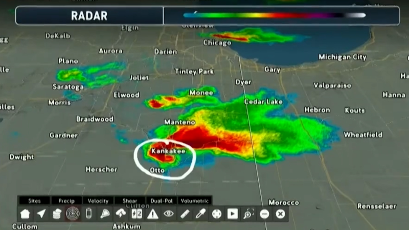
The population in the slight risk area is much larger, with over 15 million facing some type of severe weather threat. Chicago, Milwaukee, and Minneapolis are currently included in this area. However, AccuWeather meteorologists believe the risk for severe thunderstorms in much of the Chicago area will not really start until after dark Wednesday and may not occur until very late Wednesday night from the heart of the city on south. The risk of storms may last through the morning and into the afternoon Thursday.
Chicago and Milwaukee have been on the northwestern edge of showers and thunderstorms that have riddled much of the Great Lakes and Ohio Valley since late last week.
In locations where storms occur multiple times, flooding will become a concern. Although portions of the Midwest are in a drought according to the United States Drought Monitor, rain may fall too quickly for the ground to handle. Therefore, those who live in flood-prone areas will need to be aware of flooding in addition to the severe weather risk.
Soil conditions vary tremendously over the north-central United States. Some areas over the Ohio and Mississippi valleys are considered to be sufficiently moist, while areas over the northern Plains and Upper Midwest are dealing with severe to exceptional drought, according to data from the drought monitor.
Severe storms will continue to rumble Thursday, but the threat may not be as high. A cold front moving through Great Lakes, Ohio Valley and central Plains will likely have thunderstorms along and ahead of it. Heavy rain will be the primary concern, but the stronger storms could contain gusty winds.
Showers and thunderstorms will move farther to the east Friday, and the severe threat is expected to continue to diminish. The areas expected to have severe thunderstorms Wednesday are likely to have a dry end to the week as high pressure builds into the region.
Keep checking back on AccuWeather.com and stay tuned to the AccuWeather Network on DirecTV, Frontier, Spectrum, FuboTV, Philo, and Verizon Fios.
Report a Typo


News / Severe Weather
Over 20 million in Midwest at risk for severe thunderstorms
By Ryan Adamson, AccuWeather meteorologist
Updated Jul 15, 2021 12:02 AM EDT
Thunderstorms that can pack high winds and flash flooding are forecast to strike areas from the central and northern Plains to the Upper Midwest into Wednesday night, AccuWeather meteorologists say.
After some storms jolted part of the region Wednesday morning, Midwesterners may be lulled into a false sense of security, thinking that storms are over for the day. However, that won't be the case.
As energy in the atmosphere arrives from the Dakotas, more thunderstorms are expected to fire up into the evening hours.
"A ripple in the jet stream will cause strong to severe thunderstorms to erupt across the Upper Midwest through Wednesday evening," said AccuWeather Meteorologist Rob Richards.
One factor that may lessen the strength of the storms will be a lack of sunshine. When the sun comes out, the ground is heated more efficiently and can contribute to rising air. That said, the energy in the upper levels of the atmosphere is likely to compensate for the lack of sunshine, and the new storms are expected to be feisty.
"The main risks will be torrential downpours, damaging wind gusts and hail," stated Richards, but tornadoes cannot be ruled out.
Multiple tornadoes were spotted in north-central Iowa on Wednesday afternoon when storms first developed, but it is unclear how much damage the twisters caused.
CLICK HERE FOR THE FREE ACCUWEATHER APP
Thunderstorms will redevelop in southern Minnesota and northern Iowa by the evening. As individual storms first develop, all hazards, including an isolated tornado, will be possible. This second round of storms should congeal into a line with damaging winds from northern Iowa into Wisconsin and northwestern Illinois during the evening and nighttime hours.
Around 5 p.m., local time, a storm-related injury in Sauk County, Wisconsin, was reported to the National Weather Service, alongside strong winds, roof damage to a garage and downed trees.
According to the National Weather Service's Storm Prediction Center, there is an enhanced risk for severe weather for parts of Iowa, Minnesota, Wisconsin and Illinois. The enhanced threat level is the third-highest level on the SPC's five-tier scale. More than 4 million reside in this area, which includes cities such as Madison, Wisconsin, and Cedar Rapids, Iowa.
This map from the Storm Prediction Center indicates the threat level for severe thunderstorms for Wednesday, July 14, 2021.
The population in the slight risk area is much larger, with over 15 million facing some type of severe weather threat. Chicago, Milwaukee, and Minneapolis are currently included in this area. However, AccuWeather meteorologists believe the risk for severe thunderstorms in much of the Chicago area will not really start until after dark Wednesday and may not occur until very late Wednesday night from the heart of the city on south. The risk of storms may last through the morning and into the afternoon Thursday.
Chicago and Milwaukee have been on the northwestern edge of showers and thunderstorms that have riddled much of the Great Lakes and Ohio Valley since late last week.
In locations where storms occur multiple times, flooding will become a concern. Although portions of the Midwest are in a drought according to the United States Drought Monitor, rain may fall too quickly for the ground to handle. Therefore, those who live in flood-prone areas will need to be aware of flooding in addition to the severe weather risk.
Soil conditions vary tremendously over the north-central United States. Some areas over the Ohio and Mississippi valleys are considered to be sufficiently moist, while areas over the northern Plains and Upper Midwest are dealing with severe to exceptional drought, according to data from the drought monitor.
Severe storms will continue to rumble Thursday, but the threat may not be as high. A cold front moving through Great Lakes, Ohio Valley and central Plains will likely have thunderstorms along and ahead of it. Heavy rain will be the primary concern, but the stronger storms could contain gusty winds.
Showers and thunderstorms will move farther to the east Friday, and the severe threat is expected to continue to diminish. The areas expected to have severe thunderstorms Wednesday are likely to have a dry end to the week as high pressure builds into the region.
SEE ALSO:
Keep checking back on AccuWeather.com and stay tuned to the AccuWeather Network on DirecTV, Frontier, Spectrum, FuboTV, Philo, and Verizon Fios.
Report a Typo