Temperatures to spike in Pacific Northwest as summer kicks off
By
Andrew Johnson-Levine, AccuWeather meteorologist
Published Jun 21, 2022 8:26 AM EDT
|
Updated Jun 23, 2022 5:09 AM EDT
Unlike much of the country, the Pacific Northwest has had a long stretch of cooler-than-normal weather this month. There is some good news for residents across the region waiting for summer weather as AccuWeather forecasters say that a big shift in the weather pattern is about to unfold over the region.
Warmer weather is slated to arrive across the region late this week, just in time for the first weekend of summer. The new season officially kicked off on Tuesday at 2:13 a.m. PDT.
Conditions in the Northwest have been quite different for much of this month compared to the balance of the country. In Seattle, Tuesday was the first day with an above-average high temperature since June 7, with the month being more than 2 degrees Fahrenheit below normal so far. Tuesday was also the first time that Seattle reached 75 degrees this year with a high temperature of 76 degrees. The record for the latest first 75-degree reading is June 23, set in 2010.
Farther south, the cool air has also been in place this spring. Portland, Oregon, and Reno, Nevada, have both been below average for the month of June thus far. In many of these areas, a stormy and wet pattern is to blame for the cool conditions. Seattle and Portland have averaged 181 and 190 percent of the typical June rainfall, respectively.
The Pacific Northwest should be spared from most of the developing heat through Thursday with temperatures near or a few degrees above normal.
By Friday, however, changes will be on the rise. A large bulge in the jet stream situated over the central United States has acted as a roadblock in the atmosphere, but it will finally begin to weaken and slide to the east.
"With the roadblock in the atmosphere soon to be gone, the source of the Northwest's cool air will depart with it," AccuWeather Meteorologist Andrew Kienzle said.
GET THE FREE ACCUWEATHER APP
In Portland, highs in the 70s from Wednesday and Thursday will quickly be replaced by 80s Friday. This weekend, the heat will be dialed up even higher, with highs of 89 F and 97 F forecast for Saturday and Sunday. These temperatures are approximately 15 degrees above normal for late June but far from the daily records which stand in the triple digits.
Farther north, the warmer weather may take a day longer to settle in. While Seattle is only forecast to peak at 72 F Friday, highs in the upper 70s to lower 80s are expected over the weekend. Average highs for this time of year in Seattle are in the low 70s.
Hotter weather will also build east of the Cascades with highs near 90 F in Boise, Idaho, which is around 5 degrees above normal for late June.
While this round of heat is not likely to break daily records, it will still be impactful in the region. Those spending time outdoors will want to take steps to prevent heat-related illnesses, as well as know the signs of heat exhaustion and heatstroke. Those looking to cool off in area lakes and rivers will also want to exercise caution; water temperatures will be much colder than the air temperature, introducing a risk of cold water shock, forecasters say.
The cold water will partially be related to high-elevation snowmelt.
"The snowpack in the Pacific Northwest and higher mountains of British Columbia is running over 200% of normal for this time of year," said Senior Storm Warning Meteorologist William Clark.
Despite the well above-normal amount of snow remaining in the mountains, that will be greatly reduced during the upcoming warmth.
"This weekend into early next week, higher temperatures at both lower elevations and farther up in the atmosphere at the same level as the snowpack will lead to rapid snowmelt," explained Clark.
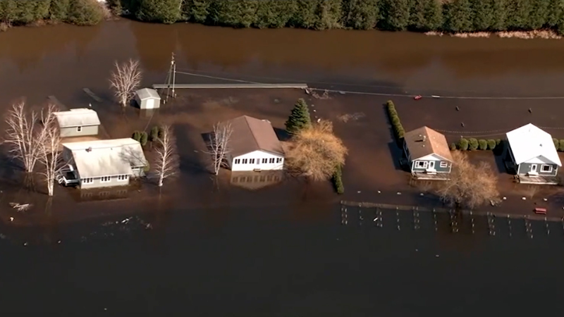
In contrast to the drought farther south, locations in the Pacific Northwest and up into British Columbia have had a surplus of precipitation. Even though this weekend is expected to be dry, the melting snow will add water to the current flooding.
"Rapid snowmelt will exacerbate the ongoing river flooding in British Columbia, with some rivers exceeding 50-year flooding, which means a 2% chance of occurring in any given year," said Clark.
The upcoming warm spell will pale in comparison to the extreme temperatures seen in the Northwest last June. All-time record highs were shattered as temperatures reached 20 to 30 degrees above normal in spots, including an especially notable high temperature of 116 F on June 28 in Portland. While this year will have some hot days in the near future, such extreme heat is not anticipated.
The upcoming warmth is predicted to carry over into early next week, but temperatures could be trimmed back down to typical late-June levels before the end of the month.
Want next-level safety, ad-free? Unlock advanced, hyperlocal severe weather alerts when you subscribe to Premium+ on the AccuWeather app. AccuWeather Alerts™ are prompted by our expert meteorologists who monitor and analyze dangerous weather risks 24/7 to keep you and your family safer.
Report a Typo


News / Weather Forecasts
Temperatures to spike in Pacific Northwest as summer kicks off
By Andrew Johnson-Levine, AccuWeather meteorologist
Published Jun 21, 2022 8:26 AM EDT | Updated Jun 23, 2022 5:09 AM EDT
Unlike much of the country, the Pacific Northwest has had a long stretch of cooler-than-normal weather this month. There is some good news for residents across the region waiting for summer weather as AccuWeather forecasters say that a big shift in the weather pattern is about to unfold over the region.
Warmer weather is slated to arrive across the region late this week, just in time for the first weekend of summer. The new season officially kicked off on Tuesday at 2:13 a.m. PDT.
Conditions in the Northwest have been quite different for much of this month compared to the balance of the country. In Seattle, Tuesday was the first day with an above-average high temperature since June 7, with the month being more than 2 degrees Fahrenheit below normal so far. Tuesday was also the first time that Seattle reached 75 degrees this year with a high temperature of 76 degrees. The record for the latest first 75-degree reading is June 23, set in 2010.
Farther south, the cool air has also been in place this spring. Portland, Oregon, and Reno, Nevada, have both been below average for the month of June thus far. In many of these areas, a stormy and wet pattern is to blame for the cool conditions. Seattle and Portland have averaged 181 and 190 percent of the typical June rainfall, respectively.
The Pacific Northwest should be spared from most of the developing heat through Thursday with temperatures near or a few degrees above normal.
By Friday, however, changes will be on the rise. A large bulge in the jet stream situated over the central United States has acted as a roadblock in the atmosphere, but it will finally begin to weaken and slide to the east.
"With the roadblock in the atmosphere soon to be gone, the source of the Northwest's cool air will depart with it," AccuWeather Meteorologist Andrew Kienzle said.
GET THE FREE ACCUWEATHER APP
Have the app? Unlock AccuWeather Alerts™ with Premium+
In Portland, highs in the 70s from Wednesday and Thursday will quickly be replaced by 80s Friday. This weekend, the heat will be dialed up even higher, with highs of 89 F and 97 F forecast for Saturday and Sunday. These temperatures are approximately 15 degrees above normal for late June but far from the daily records which stand in the triple digits.
Farther north, the warmer weather may take a day longer to settle in. While Seattle is only forecast to peak at 72 F Friday, highs in the upper 70s to lower 80s are expected over the weekend. Average highs for this time of year in Seattle are in the low 70s.
Hotter weather will also build east of the Cascades with highs near 90 F in Boise, Idaho, which is around 5 degrees above normal for late June.
While this round of heat is not likely to break daily records, it will still be impactful in the region. Those spending time outdoors will want to take steps to prevent heat-related illnesses, as well as know the signs of heat exhaustion and heatstroke. Those looking to cool off in area lakes and rivers will also want to exercise caution; water temperatures will be much colder than the air temperature, introducing a risk of cold water shock, forecasters say.
The cold water will partially be related to high-elevation snowmelt.
"The snowpack in the Pacific Northwest and higher mountains of British Columbia is running over 200% of normal for this time of year," said Senior Storm Warning Meteorologist William Clark.
Despite the well above-normal amount of snow remaining in the mountains, that will be greatly reduced during the upcoming warmth.
"This weekend into early next week, higher temperatures at both lower elevations and farther up in the atmosphere at the same level as the snowpack will lead to rapid snowmelt," explained Clark.
In contrast to the drought farther south, locations in the Pacific Northwest and up into British Columbia have had a surplus of precipitation. Even though this weekend is expected to be dry, the melting snow will add water to the current flooding.
"Rapid snowmelt will exacerbate the ongoing river flooding in British Columbia, with some rivers exceeding 50-year flooding, which means a 2% chance of occurring in any given year," said Clark.
The upcoming warm spell will pale in comparison to the extreme temperatures seen in the Northwest last June. All-time record highs were shattered as temperatures reached 20 to 30 degrees above normal in spots, including an especially notable high temperature of 116 F on June 28 in Portland. While this year will have some hot days in the near future, such extreme heat is not anticipated.
The upcoming warmth is predicted to carry over into early next week, but temperatures could be trimmed back down to typical late-June levels before the end of the month.
Continue reading:
Want next-level safety, ad-free? Unlock advanced, hyperlocal severe weather alerts when you subscribe to Premium+ on the AccuWeather app. AccuWeather Alerts™ are prompted by our expert meteorologists who monitor and analyze dangerous weather risks 24/7 to keep you and your family safer.
Report a Typo