Heavy, gusty thunderstorms aim for southern Australia
By
Courtney Travis, AccuWeather senior meteorologist
Published Apr 1, 2020 3:42 PM EDT
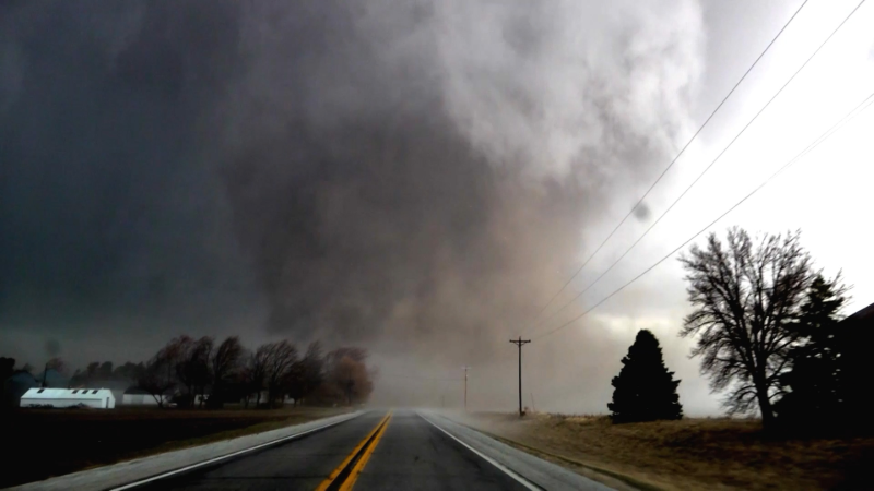
Molly and Annabel O’Dea recorded this as a massive dust storm swept through the countryside in Yongala, South Australia, on April 3.
Rounds of wet weather will target major cities in Australia as April gets underway.
In the Southern Hemisphere, March 19 marked the official end of summer and start of autumn. During its summer, Australia went through tumultuous weather including persistent dry weather that contributed to catastrophic wildfires to a cross-country tropical cyclone.
With autumn fully underway, more stormy weather is on the way for parts of the country.
"A multi-day rain event will bring waves of wet weather across Victoria, New South Wales and Queensland into the weekend," AccuWeather Senior Meteorologist Dave Houk said.
CLICK HERE FOR THE FREE ACCUWEATHER APP
The first round of stormy weather swept from eastern South Australia through New South Wales and Victoria on Thursday.
A more potent round of rain and thunderstorms is set to arrive by the weekend.
"A cold front will trigger a line of strong, gusty storms late Friday and into Saturday," said AccuWeather Senior Meteorologist Jason Nicholls.
While severe weather is not expected everywhere across stormy southeastern Australia during this time, an area of stronger thunderstorms is likely on the eastern coast of the country.
Extreme southern Queensland and the eastern half of New South Wales, including Sydney, will be the most likely areas for the stronger thunderstorms to develop, added Nicholls.
Although not widespread, these thunderstorms will be capable of some gusty winds, up to 80 km/h (50 mph) in some spots, as well as small hail and downpours. Frequent lightning and flash flooding will be the most widespread dangers.
In addition to the stormy weather on the southeastern part of Australia, AccuWeather meteorologists continue to monitor a tropical low on the northern side of the Coral Sea.
As of Thursday, local time, the low developed into a Category 1 tropical cyclone and was given the name Harold by the Australian Bureau of Meteorology. This is equivalent to a tropical storm in the Atlantic and East Pacific basins.
There is the potential for this tropical cyclone to strengthen into the weekend.
At this time, meteorologists expect the cyclone to move away from Australia, but it could impact islands in the Pacific Ocean, such as the Solomon Islands, Vanuatu and New Caledonia with heavy rain, regardless of further development.
Keep checking back on AccuWeather.com and stay tuned to the AccuWeather Network on DirecTV, Frontier and Verizon Fios.
Report a Typo


News / Severe Weather
Heavy, gusty thunderstorms aim for southern Australia
By Courtney Travis, AccuWeather senior meteorologist
Published Apr 1, 2020 3:42 PM EDT
Molly and Annabel O’Dea recorded this as a massive dust storm swept through the countryside in Yongala, South Australia, on April 3.
Rounds of wet weather will target major cities in Australia as April gets underway.
In the Southern Hemisphere, March 19 marked the official end of summer and start of autumn. During its summer, Australia went through tumultuous weather including persistent dry weather that contributed to catastrophic wildfires to a cross-country tropical cyclone.
With autumn fully underway, more stormy weather is on the way for parts of the country.
"A multi-day rain event will bring waves of wet weather across Victoria, New South Wales and Queensland into the weekend," AccuWeather Senior Meteorologist Dave Houk said.
CLICK HERE FOR THE FREE ACCUWEATHER APP
The first round of stormy weather swept from eastern South Australia through New South Wales and Victoria on Thursday.
A more potent round of rain and thunderstorms is set to arrive by the weekend.
"A cold front will trigger a line of strong, gusty storms late Friday and into Saturday," said AccuWeather Senior Meteorologist Jason Nicholls.
While severe weather is not expected everywhere across stormy southeastern Australia during this time, an area of stronger thunderstorms is likely on the eastern coast of the country.
Extreme southern Queensland and the eastern half of New South Wales, including Sydney, will be the most likely areas for the stronger thunderstorms to develop, added Nicholls.
Although not widespread, these thunderstorms will be capable of some gusty winds, up to 80 km/h (50 mph) in some spots, as well as small hail and downpours. Frequent lightning and flash flooding will be the most widespread dangers.
Related:
In addition to the stormy weather on the southeastern part of Australia, AccuWeather meteorologists continue to monitor a tropical low on the northern side of the Coral Sea.
As of Thursday, local time, the low developed into a Category 1 tropical cyclone and was given the name Harold by the Australian Bureau of Meteorology. This is equivalent to a tropical storm in the Atlantic and East Pacific basins.
There is the potential for this tropical cyclone to strengthen into the weekend.
At this time, meteorologists expect the cyclone to move away from Australia, but it could impact islands in the Pacific Ocean, such as the Solomon Islands, Vanuatu and New Caledonia with heavy rain, regardless of further development.
Keep checking back on AccuWeather.com and stay tuned to the AccuWeather Network on DirecTV, Frontier and Verizon Fios.
Report a Typo