Sandbags in San Diego? Yeah...thanks to Tropical Storm Kay
Kay, which is projected to come closer to L.A. than any tropical storm has in the last 50 years, will take an unusual path. AccuWeather takes a look at the state’s closest encounters in history.
Kay brought heavy rains and high winds along the west coast of Mexico and made landfall as a hurricane on Thursday on the west-central coast of the Baja California Peninsula. Now, a tropical storm, Kay is forecast to head northwest toward California.
While the brunt of the storm's impact will be felt in Mexico, areas of California could see some tropical rainfall regardless of where Kay goes or how well it stays organized.

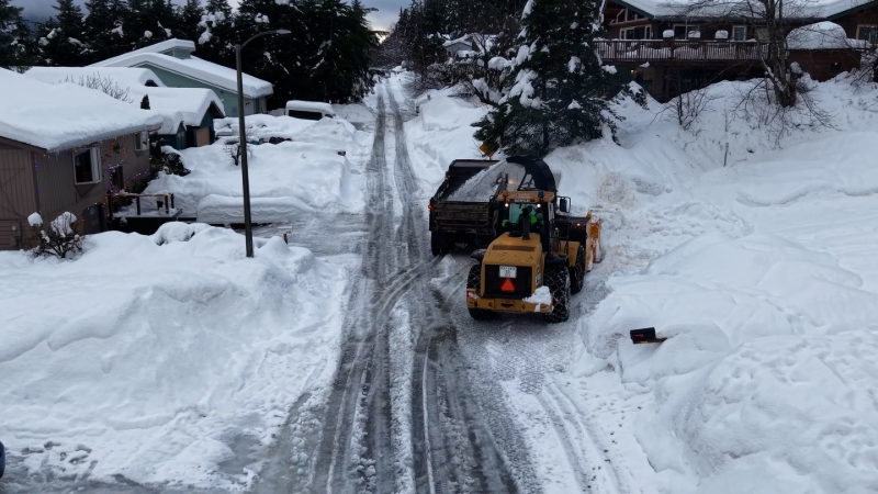
Sandbags were deployed around parts of San Diego this week to prepare for flooding from Kay. (Photo/City of San Diego)
"The tropical system will be fighting off cooler waters and land interaction as it travels north toward the end of the week. Additionally, tropical systems have a tendency to curve away from the U.S. coastline over time. However, if the storm takes a very specific track, the door is open for impacts in California," AccuWeather Meteorologist Andrew Kienzle said.
This would put many parts of the southwest U.S. at risk of flash flooding at the same time as the region is experiencing major drought and wildfires.
Although Kay won't be a hurricane by the time it nears California, but there will still be plenty of wind to cause problems, especially if not accompanied by rain.

Clouds associated with Hurricane Kay are seen over the skyline in downtown Los Angeles, Thursday, Sept. 8, 2022. (AP Photo/John Antczak)
"The main concern regarding the wind is that areas that see gusty winds but not much rainfall may end up with a high fire threat, especially given the recent scorched vegetation with the recent heat wave," said AccuWeather Senior Meteorologist Brian Thompson.
• Have the app? Unlock AccuWeather Alerts™ with Premium+
In response to the flood risk, the National Weather Service put a flood watch into effect Friday afternoon through Saturday evening for San Diego County mountains and deserts. In addition, San Diego County and Cal Fire provided free sandbags to residents in unincorporated areas to prevent flooding and erosion, according to local station NBC7. There was also an online tool for residents across the county to find locations to pick up sandbags, something residents of sunny San Diego aren't necessarily accustomed to.
Kay is the latest in a long line of storms that have come incredibly close to unleashing hurricane-force winds and rain on California. To date, no tropical storm has ever officially made landfall in California since record-keeping began in 1949. Weather impacts from storms that were once tropical in nature have blasted the state in the past, but it's been a very long time.

Hurricane Kathleen made landfall as a tropical storm in Baja California in September 1976, then the rainstorm moved into southern California, bringing record rainfall.
The record rainfall associated with a tropical cyclone in California is 14.76 inches, recorded on San Gorgonio Mountain (80 miles east of Los Angeles) during Tropical Rainstorm Kathleen in 1976. Like Kay, Kathleen was a bona fide hurricane that made landfall in the Baja California peninsula in Mexico, but Kathleen headed straight into Southern California, while Kay is expected to just skirt the edge of the coastline, before heading west into the open ocean.
The worst tropical storm in California, colloquially referred to as "El Cordonazo" or "The Lash of St. Francis," made landfall in Los Angeles in late September 1939, 11 years before official tropical storm tracking began for the East Pacific basin. It wasn't a hurricane when it hit the coast but was still strong enough to set rainfall records at the time -- almost 12 inches in some areas. Residents were so unprepared for tropical storms that the U.S. Weather Bureau, the precursor to the National Weather Service, created a new office for Southern California, which began operations the next year.

Also known as "El Cordonazo," the Long Beach Tropical Storm in 1939 made landfall at Long Beach, California, unleashing deadly flooding.
AccuWeather forecasters are predicting that Kay will come closer to Los Angeles than any other tropical system has in about 50 years.
"No storms have been within 200 miles of Los Angeles since the year 2000," said AccuWeather Senior Weather Editor Jesse Ferrell. That even includes lower-level storms like tropical depressions.
Before the turn of the century, Tropical Storm Jennifer-Katherine in 1963 was a tropical depression when it tracked from Mexico over San Diego, Ferrell said. It caused heavy rain across Southern California. Similarly, Hurricane Hyacinth in 1972 moved inland as a depression near San Diego and quickly dissipated after that, Ferrell said. Hyacinth moved closer to Los Angeles than Kay is expected to approach.
Later in 1978, Hurricane Norman made landfall on San Clementine Island, also as a tropical depression, before tracking over Long Beach, California, as an extratropical cyclone, according to Ferrell. Norman caused heavy rains across central California. In 1997, Tropical Storm Ignacio was tracked as an extratropical storm west of Santa Maria, California.
Several tropical storms have come within 400 miles of San Diego since 2010, including Hurricanes Norbert (2014), Simon (2014), Odile (2014), Dolores (2015) and Rosa (2018), so Kay will not break new ground in that area, either.
Hurricane Rosa not only soaked Baja California, but its reach extended all the way to Phoenix, where heavy rains not only put it in the history books for one of the wettest days on record for the city, but left cars stranded in the streets due to flooding.

A U.S. Navy graphic shows the forecast of Hurricane Linda on Sept. 12, 1997. At that time, the storm was projected to move towards southern California as a tropical storm.
About 25 years ago, the strongest tropical cyclone ever observed in the Eastern Pacific basin, Hurricane Linda, was, at one time, projected to hit Southern California.
"Although no official watches or warnings were issued, the NWS office in Los Angeles discussed the possible impacts in the area in their 'state forecast discussion,' and asked the media not to overdramatize the storm," said Ferrell, who reported on the event at the time.
And then there's the "San Diego Hurricane" from more than 150 years ago. Originally unknown to the broader meteorological community, a hurricane did make landfall in San Diego in 1858, over a century before such storms were tracked in any official way. At the time of the hurricane, San Diego County was tiny, with a population just shy of 4,500. Now, the county has an estimated population of 3.2 million. The damage would have been mostly confined to coastal areas, but heavy wind, rain and flooding were still felt by those living inland.


Want next-level safety, ad-free? Unlock advanced, hyperlocal severe weather alerts when you subscribe to Premium+ on the AccuWeather app. AccuWeather Alerts™ are prompted by our expert meteorologists who monitor and analyze dangerous weather risks 24/7 to keep you and your family safer.
Report a Typo