Rain returns to southern US bringing drought and wildfire relief
Multiple rounds of rain and thunderstorms this week will fall across drought-stricken areas of the South, offering short-term relief and reducing wildfire risk in locations that receive soaking rainfall.
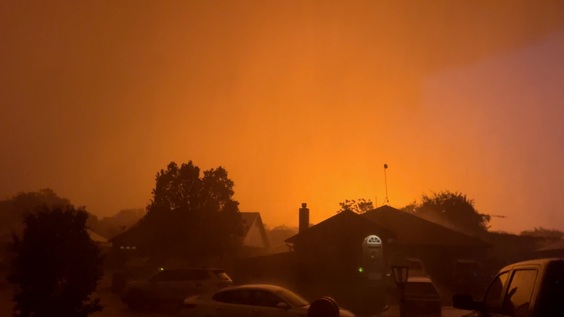
The Highway 82 Fire in Brantley County, Georgia, continues to burn and has destroyed at least 87 homes. The fire is 6% contained and has burned 22,615 acres as of April 27.
Much-needed rain will fall across parts of the south-central and southeastern United States from Tuesday to Sunday. While it may not fully end the drought, the rain will provide short-term relief — especially by easing the wildfire threat — where soaking downpours occur.
A front capable of producing severe thunderstorms in some locations will push toward the Interstate 10 and 20 corridors midweek before stalling over the region later in the week.

Downpours will focus on the southern Plains and the mid-Mississippi and Tennessee valleys on Tuesday before spreading to the central Gulf Coast and southern Atlantic Seaboard on Wednesday.
Where downpours repeat, several inches of rain are possible with the risk of localized flash flooding.

Not all of the rain will fall at once. It will come in several rounds of thunderstorms over multiple days. A general 1–4 inches of rain is forecast through the weekend from central and northern Texas to northern Alabama and western Tennessee. Farther east, from northern Florida to North Carolina, 0.50–1.00 inch of rain is likely.
Some areas may receive locally higher totals, while others could be missed entirely during this wetter pattern.

Rain has been sporadic from parts of Texas and Oklahoma to Florida, Georgia, the Carolinas and Virginia since the start of 2026. The pattern has evolved from well beyond abnormally dry conditions to extreme and exceptional drought in some locations, the two worst drought categories.
Multiple locations in the Southeast have received less than 10% of their historical average rainfall for April. This rain is more important than during the winter due to increased water demand, along with longer days and stronger sunshine that boost evaporation rates.

A lack of rain since winter, combined with dry brush and parched grassy areas in recent weeks, has pushed wildfire danger to elevated levels.
Numerous wildfires have occurred in the Southeast and southern High Plains so far this year, contributing to the more than 22,000 fires that have burned over 1.8 million acres nationwide, according to the National Interagency Fire Center.

Last week, a State of Emergency was declared in Georgia. Wildfires have led to evacuations in Georgia and Florida, destroying multiple homes.
Where rain thoroughly soaks the landscape, wildfire risk should be greatly reduced for a few days to several weeks.


Want next-level safety, ad-free? Unlock advanced, hyperlocal severe weather alerts when you subscribe to Premium+ on the AccuWeather app. AccuWeather Alerts™ are prompted by our expert meteorologists who monitor and analyze dangerous weather risks 24/7 to keep you and your family safer.
Report a Typo