Pattern change may bring some hope for wildfire-weary western US
By
Alex Sosnowski, AccuWeather senior meteorologist
Published Oct 2, 2020 4:36 PM EDT
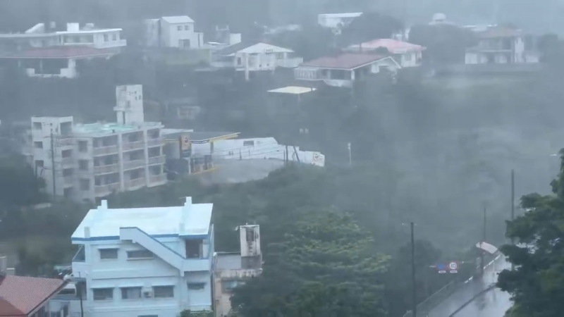
Smoke from the Glass Fire billowed into the skies over Calistoga, California, on Oct. 1, as the fire burned out of control. It’s scorched more than 58,000 acres since it started on Sept. 27.
Amid one of the worst wildfire seasons on record for the western United States, forecasters say a big weather pattern change will unfold later this week that will deliver vital rain and cooler conditions. The pattern shift will also serve as a respite from the persistent dryness and record-challenging warmth in much of the region.
Although the rain is not expected to arrive until the second half of the week, it is still welcome news for beleaguered firefighters on the front lines fighting a number of large blazes that have scorched millions of acres across the West as well as those who are suffering from poor air quality.
The number and rapid spread of fires this season have been brought on by drought, dry fuels, locally gusty winds and dry, hot air.
CLICK HERE FOR THE FREE ACCUWEATHER APP
Hot and dry conditions of late have been brought about by a large northward bulge in the jet stream over the western U.S.
"In this configuration, moisture from the Pacific is locked out of the region as storms are deflected well to the north over Alaska and then into central Canada, rather than moving directly eastward and inland from the ocean," AccuWeather Senior Meteorologist Brett Anderson said.
The same pattern with its warm air aloft promotes heat near the surface due to periodic offshore winds.
However, there continues to be indication that the jet stream will experience a major shift later this week.
"It appears the northward bulge will move toward the Central states and a corresponding southward dip will advance eastward from the central Pacific to along the West Coast of the U.S.," Anderson explained.
This setup will help not only to drive moisture inland from the Pacific but also to lower temperatures substantially over the western quarter to third of the nation.
In one scenario, a series of storms with rain would move onshore beginning late this week and perhaps continuing into the middle of October.
While things could still change, the pattern should at least bring some cloud cover, higher humidity levels and lower temperatures throughout the Pacific Coast states and perhaps to areas east of the Sierra Nevada. At this time, the best chance of showers appears to be from Northern California to Washington.
Prior to the change in the weather pattern, some cooling from sea breezes will be felt along much of the Pacific coast into early week. Areas inland are forecast to remain very warm to hot into the middle of the week.
AccuWeather's long-range team of meteorologists lead by Paul Pastelok are expecting winter to get rolling early on this year.
While the pattern starting late this week might not be the true beginnings of the setup for the winter, it may be giving a hint of what is to come and that the clock may be ticking on the fire season for many areas in general.
Even with the upcoming forecast pattern change, there will likely to continue to be large fires burning, and some areas could be missed by significant rainfall.
Keep checking back on AccuWeather.com and stay tuned to the AccuWeather Network on DirecTV, Frontier and Verizon Fios.
Report a Typo


News / Weather Forecasts
Pattern change may bring some hope for wildfire-weary western US
By Alex Sosnowski, AccuWeather senior meteorologist
Published Oct 2, 2020 4:36 PM EDT
Smoke from the Glass Fire billowed into the skies over Calistoga, California, on Oct. 1, as the fire burned out of control. It’s scorched more than 58,000 acres since it started on Sept. 27.
Amid one of the worst wildfire seasons on record for the western United States, forecasters say a big weather pattern change will unfold later this week that will deliver vital rain and cooler conditions. The pattern shift will also serve as a respite from the persistent dryness and record-challenging warmth in much of the region.
Although the rain is not expected to arrive until the second half of the week, it is still welcome news for beleaguered firefighters on the front lines fighting a number of large blazes that have scorched millions of acres across the West as well as those who are suffering from poor air quality.
The number and rapid spread of fires this season have been brought on by drought, dry fuels, locally gusty winds and dry, hot air.
CLICK HERE FOR THE FREE ACCUWEATHER APP
Hot and dry conditions of late have been brought about by a large northward bulge in the jet stream over the western U.S.
"In this configuration, moisture from the Pacific is locked out of the region as storms are deflected well to the north over Alaska and then into central Canada, rather than moving directly eastward and inland from the ocean," AccuWeather Senior Meteorologist Brett Anderson said.
The same pattern with its warm air aloft promotes heat near the surface due to periodic offshore winds.
However, there continues to be indication that the jet stream will experience a major shift later this week.
"It appears the northward bulge will move toward the Central states and a corresponding southward dip will advance eastward from the central Pacific to along the West Coast of the U.S.," Anderson explained.
This setup will help not only to drive moisture inland from the Pacific but also to lower temperatures substantially over the western quarter to third of the nation.
In one scenario, a series of storms with rain would move onshore beginning late this week and perhaps continuing into the middle of October.
While things could still change, the pattern should at least bring some cloud cover, higher humidity levels and lower temperatures throughout the Pacific Coast states and perhaps to areas east of the Sierra Nevada. At this time, the best chance of showers appears to be from Northern California to Washington.
Related:
Prior to the change in the weather pattern, some cooling from sea breezes will be felt along much of the Pacific coast into early week. Areas inland are forecast to remain very warm to hot into the middle of the week.
AccuWeather's long-range team of meteorologists lead by Paul Pastelok are expecting winter to get rolling early on this year.
While the pattern starting late this week might not be the true beginnings of the setup for the winter, it may be giving a hint of what is to come and that the clock may be ticking on the fire season for many areas in general.
Even with the upcoming forecast pattern change, there will likely to continue to be large fires burning, and some areas could be missed by significant rainfall.
Keep checking back on AccuWeather.com and stay tuned to the AccuWeather Network on DirecTV, Frontier and Verizon Fios.
Report a Typo