2021 to begin with thundery downpours for portions of the Southeast
By
Ryan Adamson, AccuWeather meteorologist
Updated Jan 2, 2021 1:02 AM EST
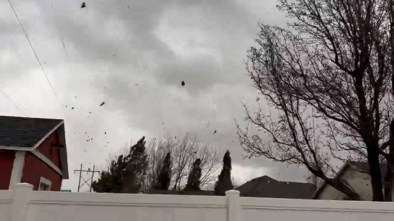
An EF1 tornado damaged 13 mobiles homes as it tore through Corsicana, Texas, on Dec. 30.
A weekend of severe weather will make for a rude welcome to 2021 for many in the southeastern United States in the coming days.
As an area of low pressure spreads snow and ice to areas of the Plains, Great Lakes and Northeast into Friday night, a cold front trailing from the low will bring liquid precipitation and thunderstorms to the Southeast.
On New Year's Eve, lightning lit up the sky in much of southern and eastern Texas. The storm then began moving eastward on Friday, bringing thunderstorms and even a few tornadoes with it.
By early Friday night, there were already three tornado reports in Georgia, according to the National Weather Service. In Monroe County, a woman was injured after a tornado flipped a mobile home she was inside near the intersection of GA-18 and GA-87. Trees in the area were also reportedly uprooted and some branches had snapped.
There were also two reports in Crawford County of damage caused after a tornado ripped through the area. Along with damage reported to many trees in the area, Emergency Medical Associates (EMA) reported that a home in Salem lost its roof, and another home in Musella sustained damage to its roof.
A disturbance in the upper levels of the atmosphere will be trekking through Missouri and Illinois into Friday night. These disturbances often help to add energy to thunderstorms that develop. Since the energy will be far removed from where the thunderstorms are expected to move through, the storms should not become overly strong. That said, residents should not let their guard down.
"Locally gusty thunderstorms will rumble to life as a cold front slowly drifts eastward across portions of the Southeast into Friday night," stated AccuWeather Meteorologist Mary Gilbert. "While a majority of the storms that fire up will remain below severe criteria, a few can become feisty and may lead to local wind damage," she continued.
Regardless of severe weather potential, any thunderstorm is always capable of producing very heavy rain in short period of time, which could lead to instances of flooding. This will be especially true in any locations that receive multiple thunderstorms.
Fayetteville, North Carolina; Columbia, South Carolina; Augusta and Macon, Georgia; Atlanta; and Tallahassee, Florida, are examples of cities that will be at risk of thunderstorms into Friday night. Travelers on portions of interstates 20 and 95 could experience delays in any heavier thunderstorms.
CLICK HERE FOR THE FREE ACCUWEATHER APP
The front and thunderstorms will continue to move eastward on Saturday.
"A secondary push of warm, moist air late Saturday can lead to additional heavy thunderstorms for the first weekend of 2021 in the Southeast," said Gilbert. "Any storm that develops late in the day Saturday through the overnight hours can produce heavy downpours that may lead to flash flooding issues for some."
A few thunderstorms may rumble in the Outer Banks on Sunday, especially in the morning, before the low pressure moves offshore.
With the cold front moving into the central Florida Peninsula, a few showers may dampen Orlando and Tampa on Sunday.
Those showers will continue southward into Miami and the Keys on Monday morning before the front moves to the south of the Sunshine State.
Keep checking back on AccuWeather.com and stay tuned to the AccuWeather Network on DirecTV, Frontier and Verizon Fios.
Report a Typo


News / Severe Weather
2021 to begin with thundery downpours for portions of the Southeast
By Ryan Adamson, AccuWeather meteorologist
Updated Jan 2, 2021 1:02 AM EST
An EF1 tornado damaged 13 mobiles homes as it tore through Corsicana, Texas, on Dec. 30.
A weekend of severe weather will make for a rude welcome to 2021 for many in the southeastern United States in the coming days.
As an area of low pressure spreads snow and ice to areas of the Plains, Great Lakes and Northeast into Friday night, a cold front trailing from the low will bring liquid precipitation and thunderstorms to the Southeast.
On New Year's Eve, lightning lit up the sky in much of southern and eastern Texas. The storm then began moving eastward on Friday, bringing thunderstorms and even a few tornadoes with it.
By early Friday night, there were already three tornado reports in Georgia, according to the National Weather Service. In Monroe County, a woman was injured after a tornado flipped a mobile home she was inside near the intersection of GA-18 and GA-87. Trees in the area were also reportedly uprooted and some branches had snapped.
There were also two reports in Crawford County of damage caused after a tornado ripped through the area. Along with damage reported to many trees in the area, Emergency Medical Associates (EMA) reported that a home in Salem lost its roof, and another home in Musella sustained damage to its roof.
A disturbance in the upper levels of the atmosphere will be trekking through Missouri and Illinois into Friday night. These disturbances often help to add energy to thunderstorms that develop. Since the energy will be far removed from where the thunderstorms are expected to move through, the storms should not become overly strong. That said, residents should not let their guard down.
"Locally gusty thunderstorms will rumble to life as a cold front slowly drifts eastward across portions of the Southeast into Friday night," stated AccuWeather Meteorologist Mary Gilbert. "While a majority of the storms that fire up will remain below severe criteria, a few can become feisty and may lead to local wind damage," she continued.
Regardless of severe weather potential, any thunderstorm is always capable of producing very heavy rain in short period of time, which could lead to instances of flooding. This will be especially true in any locations that receive multiple thunderstorms.
Fayetteville, North Carolina; Columbia, South Carolina; Augusta and Macon, Georgia; Atlanta; and Tallahassee, Florida, are examples of cities that will be at risk of thunderstorms into Friday night. Travelers on portions of interstates 20 and 95 could experience delays in any heavier thunderstorms.
CLICK HERE FOR THE FREE ACCUWEATHER APP
The front and thunderstorms will continue to move eastward on Saturday.
"A secondary push of warm, moist air late Saturday can lead to additional heavy thunderstorms for the first weekend of 2021 in the Southeast," said Gilbert. "Any storm that develops late in the day Saturday through the overnight hours can produce heavy downpours that may lead to flash flooding issues for some."
A few thunderstorms may rumble in the Outer Banks on Sunday, especially in the morning, before the low pressure moves offshore.
With the cold front moving into the central Florida Peninsula, a few showers may dampen Orlando and Tampa on Sunday.
Those showers will continue southward into Miami and the Keys on Monday morning before the front moves to the south of the Sunshine State.
Related:
Keep checking back on AccuWeather.com and stay tuned to the AccuWeather Network on DirecTV, Frontier and Verizon Fios.
Report a Typo