Neighborhoods in Jamaica Beach, Texas, were flooded on Sept. 20 during high tide, as Tropical Storm Beta churned in the Gulf of Mexico.
Beta has now weakened and is expected to track slowly northeastward along the Texas coast into Wednesday before picking up forward speed and moving through Louisiana on Thursday. AccuWeather meteorologists caution heavy, tropical rainfall will continue across parts of Oklahoma and eastern Texas through Tuesday night, and across Arkansas and Louisiana through Wednesday as the storm begins to track across the Deep South. Although Beta’s wrath is winding down, Hurricane Teddy is now barreling toward Atlantic Canada, on course to blast through Nova Scotia and Newfoundland through Wednesday night. This is the end of AccuWeather’s live coverage of Beta and the final update for this live blog. For more recap coverage of Beta, click here and stay tuned to AccuWeather.com and the AccuWeather TV Network.
Business owners told AccuWeather National Reporter Bill Wadell that Tropical Storm Beta is yet another setback after a summer stunted by the coronavirus pandemic. “Before even the hurricane season even started, we had 3 or 4 months of just really bad economics,” Galveston, Texas, resident Zachary Mayeux said. Some people in the area told Wadell this was the worst flooding event they’ve seen in their neighborhood since Hurricane Harvey.
Accuweather National Reporter Bill Wadell said that rescues started late Monday night and lasted more than 12 hours. Volunteers helped people and families trapped in the water. Downpours from Beta caused Keegans Bayou to jump out of its banks and onto roadways. “I actually picked my mother up from the airport, and I dropped her off. I thought it would be better to head back to my place before it got too bad, it started raining hard again. However, as soon as I got on the road I ran into the flood waters,” Houston resident Lashuntrice Bradley told Wadell. Bradley was stuck in the flood but volunteers and neighbors with lifted pickup trucks came to her rescue. “I really think that it's excellent that they’re helping out. I don’t know what I would have done without them,” Bradley said. According to Wadell, tow truck drivers had a hard time keeping up with all of the calls for help. Some tow truck drivers said they’ve already towed dozens of cars that are totaled.
The centers of Tropical Depression Beta and Hurricane Teddy are separated by 2,000 miles, but the two storms appear to have a connection when looking at them on satellite. NOAA’s GOES-East weather satellite captured this image on Tuesday afternoon, showing a band of clouds stretching southward from Teddy across the Atlantic Ocean, extending all the way down over Cuba and meeting up with the eastern edge of Beta. Some people on social media pointed out that the cloud formation almost looks like a smile. AccuWeather Meteorologist and Senior Weather Editor Jesse Ferrell also pointed out that a connection can even be made to a storm just off the coast of the United Kingdom.

Hurricane Teddy and Tropical Depression Beta seen spinning on Tuesday afternoon from NOAA's GOES-East weather satellite. (NOAA)
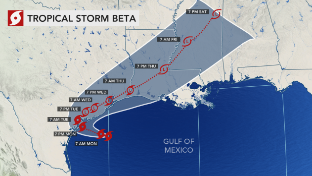
The forward motion of Tropical Depression Beta is picking up as it tracks toward Louisiana. At 10 a.m. CDT Tuesday, the center of Beta was moving at just 2 mph, but by 4 p.m. CDT, it was moving at a brisk pace of 5 mph, the National Hurricane Center said. As the storm’s motion increased, maximum sustained winds dropped from 35 mph to 30 mph. Beta is forecast to remain weak as it tracks toward the southeastern U.S.
Drivers planning to travel on Interstate 610 in the Houston area may need to look for an alternate route to their destination as part of the highway was submerged in both lanes on Tuesday afternoon. AccuWeather National News Reporter Bill Wadell was on the scene, showing the highway covered in what appeared to be feet of water. This is just one of many roads across the city that is closed due to flooding from Beta.
Samuel Peña, the fire chief for the Houston Fire Department, said on Twitter Tuesday that there have been nearly 100 water rescues from roadways over a 16-hour span. "Given the sheer number of emergencies, not a good bet to think you’ll be rescued before your vehicle is overcome with water or suffer a near drowning incident," he wrote. Houston Mayor Sylvester Turner said there are about 70 high water locations in the city, but there hasn't been any reports of water inside homes or businesses, according to Sally MacDonald, a reporter for Fox 26 in Houston.

Heavy rains from Tropical Storm Beta turned roads into rivers across the Houston area, leaving many vehicles stranded in deep floodwaters on Tuesday, Sept. 22, 2020. (Brandon Clement / LSM)
Beta's flooding will remain a concern across the lower Mississippi Valley into late this week with the worst conditions predicted from southeastern Texas to parts of southern and western Louisiana, AccuWeather meteorologists say.

“Prolonged road closures may result. Some communities could be cut off from emergency or medical services for hours or even perhaps multiple days," AccuWeather's top hurricane expert Dan Kottlowski warned. "Floodwaters in some locations along the Gulf Coast may take a week or more to recede."

A car is submerged in Houston, Texas, on Sept. 22, 2020. (Photo/Jonathan Petramala)
When Beta made landfall near the southern end of the Matagorda Peninsula late Monday night, it allowed the 2020 Atlantic hurricane season to tie a record. Beta is the ninth storm to make landfall in the continental U.S. so far this season, and according to Colorado State University Meteorologist Philip Klotzbach, that ties 2020 with the 1916 Atlantic hurricane season for most named storms to make landfall on record. The storms that have made landfall in the U.S. so far are:
Bertha
Cristobal
Fay
Hanna
Isaias
Marco
Laura
Sally
Beta
Watch a video below to see how turbulent seas became near Galveston, Texas, on Sept. 21 as Beta neared landfall.
Beta has weakened to a tropical depression over Texas, according to the National Hurricane Center's latest advisory. The storm's maximum sustained winds have dipped to 35 mph, below the tropical storm threshold of 39 mph. The tropical system is located about 15 miles east-northeast of Victoria, Texas, and continues to produce a severe flood threat across southeastern Texas. All remaining tropical storm watches and warnings have been discontinued.

Videos posted to social media show high water levels at multiple creek and bayous around southeastern Texas. Sergio Chapa, a reporter in the Houston area, posted a video to Twitter of flooding along Brays Bayou in southwestern Houston. Chapa reported that the Bayou jumped its banks Tuesday morning and also flooded out a pedestrian tunnel at a nearby park. Meanwhile, in League City, Texas, about 26 miles south of Houston, city officials shared a video of high water levels at nearby Clear Creek and warned that the flooding could worsen.
Rainfall totals have reached up to 12 inches over the past two days in the Houston, Texas, area and more rain is on the way as Tropical Storm Beta continues its slow journey. Houston officials are urging people to avoid traveling today as many roads are already inundated in the southern and southwestern parts of the city. On Monday night, one motorist on the way to pick up his son had to be rescued after he drove into deep water on a submerged roadway in Houston. One bystander happened to capture the incident on video and was able to help the motorist out of the waist-deep water and get him to safety. Click here to watch the dramatic scene unfold.

A mam escaped from his flooded car amid Beta while on his way to pick up his son. (Twitter/@PastorJaimeG)
As of 7 a.m. CDT, Beta was about 10 miles east-southeast of Victoria, Texas, a city about 120 miles southwest of Houston. Beta is barely hanging on as a tropical storm, with maximum sustained winds of 40 mph. The tropical system is crawling to the northwest at a meager 3 mph, but its impacts are still going to be significant.
Houston Mayor Sylvester Turner said city officials are monitoring bayous around the city "very closely," particularly around the south and southwest parts of Houston. "If you don’t have to get on the road right now, stay home for now and that includes city employees," Turnery said on Twitter. "Stay home for now and pay attention to weather reports." In the Houston metro area, widespread flooding has shut down travel on roadways such as SH-288, leaving multiple vehicles stuck in the high waters. Below is a look at some of the highest rainfall totals produced by Beta so far.

As Beta continues to crawl along the Texas coastline at 3 mph, flash flooding dangers continue to mount. Flash flood warnings are in effect for several counties, including areas just southwest of Houston, where 6-8 inches of rain has fallen. Video footage on Twitter showed extensive flooding along U.S. Route 59 in Houston earlier Monday night.
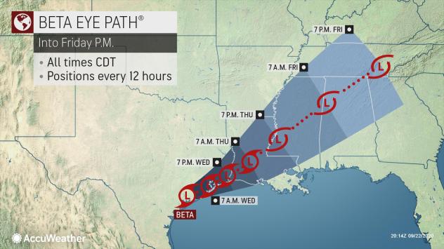
The National Hurricane Center released an update stating that Tropical Storm Beta made landfall along the Texas coast near the southern end of the Matagorda Peninsula around 10 p.m. CDT Monday. The peninsula is located near Port O'Connor, Texas. This marks the ninth named storm to make landfall in the United States this season.
Forecasters say it's possible that Beta wanders offshore again on Tuesday or Wednesday, perhaps making a second landfall in Louisiana later in the week, likely in an even weaker state.

The center of Tropical Storm Beta is just 5 miles east of Port O'Connor, Texas, according to the latest update from the National Hurricane Center. The storm's maximum sustained winds are at 45 mph as it continues its northwest crawl at 3 mph.

Heavy rainfall from Beta is seen dousing the Texas coastline as the tropical storm nears landfall on Monday night. (AccuWeather)
A Flash Flood Warning, which encompasses southwest Houston, Texas, has been extended until 11:30 p.m. CDT. The Flash Flood Warning includes Pearland, League City and Sugar Land, Texas. A rain gauge south of Houston in Pearland, Texas reported 5.44 inches of rain fell in the last 6 hours and 7.72 inches in the past 2 days. Radar estimates that 6 to 9 inches could have fallen nearby.

According to the National Hurricane Center (NHC) 7 p.m. CDT update, Beta is maintaining a pace of 5 mph with maximum sustained winds gusts near 45 mph. Flooding already began in the Port O'Connor area early Monday morning. Officials are pleading with residents to not attempt to drive on flooded roads. Over half of all flood-related drownings occur when a vehicle is driven into dangerous floodwaters, the Centers for Disease Control and Prevention (CDC) reported.
Tropical Storm Beta’s storm surge and high tide flooded the Scholes Airport in Galveston, Texas. The airport reported the roadways at the airport were flooded at 11:30 a.m. on Monday as Beta approached the coast. Storm surge will come back with the high tide this evening.

Storm surge flooded the Scholes Airport in Galveston, Texas on Monday. (Image via Scholes Airport)

Storm surge flooded the Scholes Airport in Galveston, Texas on Monday. (Image via Scholes Airport)
Watches and warnings are in effect across Texas as Tropical Storm Beta spins closer to shore. A Storm Surge Warning, meaning there is a danger of life-threatening inundation from rising water moving inland from the coastline, is in effect for Port Aransas, Texas to Sabine Pass, Texas. A Tropical Storm Warning is in effect for Port Aransas, Texas to Morgan City, Louisiana. The AccuWeather RealImpact™ Scale was lowered to a 1 for Beta with less widespread flooding anticipated along with wind gusts mainly below 70 mph. The heaviest rainfall forecast from Beta is forecast to be less than Sally, although 8 to 16 inches can still cause flooding. Fortunately, the heaviest rain from Beta is expected to occur farther west compared to Sally.
Beta is moving toward the northwest at a slow pace of 5 mph with maximum sustained winds gusts near 45 mph with higher gusts, according to the National Hurricane Center (NHC) 4 p.m. update. On the forecast track, the center of Beta will continue to move toward the central coast of Texas on Monday and will likely move inland by Monday night. Beta is forecast to remain near or just offshore the coast of southeastern Texas on Tuesday and Wednesday, the NHC reports. Little change in strength is forecast before the storm makes landfall on the Texas coast. While rainfall totals will be less than what fell from Sally, AccuWeather meteorologists say a track farther west will keep the risk for flash flooding and coastal flooding farther west than areas that are still recovering from Sally.
Radar images show the precipitation from Tropical Storm Beta is very scattered, with the outermost rain bands as far west as western and northwest Texas, as far north as southern Oklahoma and southern Arkansas and as far east as the Florida panhandle. Rain from Beta was falling on Monday in the Big Lake Texas area and, to the east, in Panama City, Florida – a distance of about 950 miles. AccuWeather meteorologist and senior weather editor Jesse Ferrell said, “The lack of precipitation in the middle speaks to the weakness of the storm.” Ferrell said this phenomenon is not unusual, but can be “weird looking” on radar with a good center. “Normally you'd see a mass of precipitation in the center and the outer bands you see here,” he added.

AccuWeather radar on Monday afternoon showed scattered precipitation from Tropical Storm Beta spreading across parts of seven states and spanning nearly 1,000 miles west to east. (AccuWeather)
Texas Gov. Greg Abbott issued a Disaster Declaration for 29 Texas counties on Monday as Beta churned toward the Gulf Coast. “As Tropical Storm Beta approaches the coast, I urge Texans in the path of the storm to remain vigilant and take necessary precautions to keep themselves and their loved ones safe from flooding, storm surge, and other impacts from this severe weather,” Abbott announced. “The State of Texas is working closely with local officials on the ground to provide the resources our communities need to respond to Tropical Storm Beta and keep residents safe.” The declaration authorizes the use of all available resources of state government and of political subdivisions that are reasonably necessary to cope with this disaster, according to the news release.
Air Force Reserve reconnaissance aircraft data indicated that Tropical Storm Beta's maximum sustained winds have decreased to 45 mph, according to the National Hurricane Center (NHC) 2 p.m. update. As the storm crawls closer to the central Texas coast, now 65 miles south-southwest of Freeport, Texas, outer rain bands are stretching onshore along the central and upper Texas coast. Areas just south of Galveston are being soaked by tropical downpours. Tropical-storm-force wind gusts are reaching 175 miles out from Beta's center. An observation site in Port O'Connor, Texas, measured a wind gust of 43 mph, and a buoy site just offshore of Galveston, Texas, also recorded a wind gust of 43 mph, the NHC said.

Louisiana Gov. John Bel Edwards declared a state of emergency for Tropical Storm Beta on Monday, the third time within a month that he's declared a state of emergency for an approaching tropical system. "Tropical Storm warnings are in effect for much of Louisiana’s coastline and the slow movement of Tropical Storm Beta puts southwest Louisiana at risk for flash flooding and river flooding today through Wednesday or Thursday," Edwards said on Twitter. The governor warned of a storm surge that could reach up to 4 feet in some areas, and said Beta could be especially problematic for areas devastated by Hurricane Laura which made landfall in southwestern Louisiana on Aug. 27 as a ferocious Category 4 storm. Today, there are still more than 20,000 customers without power in the state as a result of Laura.
High Island, Texas, located about 34 miles north of Galveston and 80 miles northeast of Houston, was dealing with storm surge flooding from Beta as early as this past Saturday as big waves lashed the coast, sending water on roads in some areas. One resident said the constant tropical threats in the area were becoming "monotonous," while another said he would wait until the last minute to evacuate. Click here to watch a brief video from Saturday the storm's impacts in the area.

Residents stand near the water's edge in High Island, Texas, where Tropical Storm Beta was bringing impacts as early as Saturday, Sept. 19, 2020. (ABC News)
Forecasters caution that Beta should not be overlooked just because it is not expected to become a hurricane. The storm's flooding is considered serious enough to warrant Beta being rated a 1 on the AccuWeather RealImpact™ Scale for Hurricanes. The RealImpact™ Scale for Hurricanes is a 6-point scale with ratings of less than 1 and 1 to 5 that was introduced by AccuWeather in 2019 to rate tropical systems based on multiple impacts, rather than just wind, like the Saffir-Simpson Hurricane Wind Scale does.

Beta had increased its forward speed according to the latest advisory from the National Hurricane Center at 10 a.m. CDT. The storm was moving to the west-northwest at 7 mph, up from 6 mph at the 7 a.m. CDT update. Beta was about 55 miles southeast of Port O'Connor, Texas, and had maximum sustained winds of 50 mph.
Forecasters caution that Beta should not be overlooked just because it is not expected to become a hurricane. The storm's flooding is considered serious enough to warrant Beta being rated a 1 on the AccuWeather RealImpact™ Scale for Hurricanes. The RealImpact™ Scale for Hurricanes is a 6-point scale with ratings of less than 1 and 1 to 5 that was introduced by AccuWeather in 2019 to rate tropical systems based on multiple impacts, rather than just wind, like the Saffir-Simpson Hurricane Wind Scale does.
The city of Galveston, Texas, is in the crosshairs of Tropical Storm Beta and it is projected to be in the swath of Texas coast where the storm could make landfall later tonight. Beta was about 120 miles south-southwest of Galveston of 7 a.m. local time, but the storm has already made its presence felt. According to KHOU 11 in Houston, the storm's rough waves washed away a part of Galveston's 61st street fishing pier. The website Saltwater-Recon.com had a livestream of the pier as it was washed away. The video showed workers trying to save good sections of the pier by separating it from the section most at risk for washing away, according to Saltwater-Recon's Facebook post. The section that fell off was found several miles away Monday morning, KHOU 11 reported.
Even though Beta is forecast to make landfall along the southern Texas coast later Monday, likely between Corpus Christi and Galveston, the storm's impacts were felt across much of the Gulf Coast this weekend. In New Orleans, Lakeshore Drive had to be closed on Sunday as water levels rose on Lake Pontchartrain. A flash flood watch remains in effect for New Orleans as the city could receive up to 8 inches of rain from the storm. The National Weather Service in New Orleans said coastal flooding continued at many locations Monday morning and some roads were impassible.

Tropical Storm Beta was stirring up rough waters in Lake Pontchartrain on Sunday, and coastal flooding in and around New Orleans as the storm lurched closer to the coastline. (Twitter/ NOLA Ready)
Even though Beta will fall short of hurricane strength, the storm still poses a serious risk across southeastern Texas and into Louisiana as the storm's slow movement will result in serious flooding that could last for days. AccuWeather meteorologists say widespread rainfall totals of 4-8 inches are expected across southeastern Texas and into southern Louisiana. Higher rainfall totals on the order of 8-16 inches with an AccuWeather Local StormMax™ of 24 inches are expected to occur along the Texas and Louisiana coasts.
As was the case with Hurricane Sally just last week, Beta's slow movement is the biggest cause for concern. As of 7 a.m. CDT Monday, Beta was moving around 6 mph. The 2 feet of rain forecasters are calling for is a serious threat to lives and properties, but it's also well short of some of the astounding rainfall totals the southeastern Texas region has seen over the past several years from tropical cyclones.
In 2017, the historic Hurricane Harvey dropped 60.58 inches of rain in Nederland, Texas. Harvey is the most significant rainfall event in U.S. history in scope and peak rainfall amounts, according to the National Hurricane Center. In September 2019, Tropical Storm Imelda's deluge resulted in 44.29 inches south-southwest of Fannett, Texas, making it the seventh-wettest tropical cyclone to impact the U.S.


According to the latest information from the National Hurricane Center on Tropical Storm Beta, the storm is located 95 miles southeast of Port O'Connor, Texas. With maximum sustained wind speeds of 50 miles per hour, Beta is moving westward at 6 mph and is expected to continue doing so until it takes a sharp, northeastern turn on Tuesday.
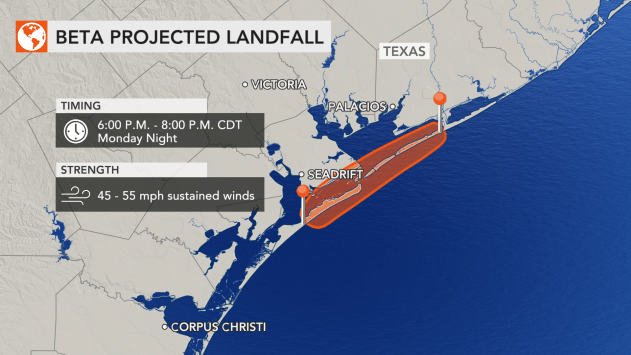
AccuWeather meteorologists expect Beta to have the best opportunity to make landfall along the coast of Texas between Corpus Christi and Galveston, perhaps near Matagorda Bay, late Monday or early Tuesday. This would be the ninth system to make landfall in the United States this season.
The record-shattering 2020 Atlantic hurricane season continues marching along, with Beta certainly doing its part. The tropical storm became the earliest 23rd-named storm system of a season, breaking the mark set in 2005 by 34 days. Along with that 2005 season, 2020 is only the second year ever to exhaust the pre-determined list of 21 names and require the use of names from the Greek alphabet.
The 2005 hurricane season saw a total of 28 named storms, which included an unnamed storm identified in a post-season analysis. The last storm to be named that year was Zeta, the sixth letter of the Greek alphabet, on Dec. 30.

Ahead of Beta making landfall on the Gulf Coast, New Orleans Mayor LaToya Cantrell announced on Sunday that a Flash Flood Watch is in effect for the city that will extend through Wednesday. Neutral ground parking went into effect at 6 p.m. CDT on Sunday night in anticipation for the flooding and will continue until further notice. "Please do not block intersections, streetcar tracks, or bike paths," Cantrell said.
Texas Gov. Greg Abbott urged residents to remain vigilant on Sunday as Tropical Storm Beta looms over the coast. "I call on all Texans in the Gulf Coast region to heed the advice of local officials and take the necessary precautions to keep themselves and their loved ones out of harm's way," Abbott said in a news release. "The State of Texas is prepared to support communities in the path of the storm, where substantial amounts of rainfall and flash flooding are a significant threat. We will continue to closely monitor the storm and work collaboratively with officials to ensure our fellow Texans are safe." The news release encouraged residents to take special precautions, like keeping important documents in a water-safe container and preparing an emergency supply kit, which should include face masks and hand sanitizer amid the COVID-19 pandemic.


