Coldest air of season so far bringing snow to Northeast
Cold air that was pent up over the Upper Midwest has broken out of its atmospheric cage and is forecast to deliver some cold and snowy conditions to the Northeast this week that will make it feel like December for a brief time, AccuWeather meteorologists say.
Late last week, portions of Minnesota, northern Wisconsin and the Upper Peninsula of Michigan got their first light snowfall of the season, mainly on non-paved surfaces. Since then a reinforcing dose and stronger blast of cold air arrived and spread into areas hundreds of miles farther to the Southeast.

Snowfall totals from Sunday night to Tuesday evening.
Over the past 36 hours, snow has quickly piled up in Michigan's Upper Peninsula as well as northern Wisconsin. While snow began to wind down in that area Tuesday morning, some of the highest totals have been observed near Ironwood, Michigan, a town along the border of the two states. Over a foot of snow has been common to see in that region, with locally up to 18 inch amounts.
Additional snow occurred farther to the south, in northern portions of Indiana and Ohio on Monday night. In the spots where snow has fallen most heavily, up to 6 inches have been reported. Elsewhere, snow was light enough to not pile up. However, many spots, including the Chicagoland area, saw their first flakes of the season.
Through midweek, this surge of cold air will continue a southward plunge, making it feel more like January than October for many.
"A pronounced dip in the jet stream will pivot slowly eastward into midweek, and that will allow the cold air to penetrate much farther to the east and south, when compared to this weekend," AccuWeather Senior Meteorologist Brian Wimer said.
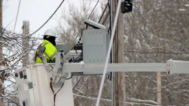
Late Monday, a band of heavy, wet snow developed in northern Indiana. The nature of the snow allowed it to cling to trees and power lines. In Syracuse, Indiana, a mix of snow and rain downed both trees and power lines Monday evening, leaving over 6,000 customers in Kosciusko County without power according to PowerOutage.US. As of early Wednesday morning, more than 14,000 utility customers were without power in Michigan. In Indiana, most power had been restored with just over 100 customers still in the dark.
Farther east, some snowflakes were spotted as early as Monday night in the eastern Great Lakes region and the central Appalachians. On Tuesday, snowfall expanded to parts of Kentucky.

On this radar image, captured on Wednesday morning, Oct. 19, 2022, snow (blue) was advancing eastward across portions of western and central Pennsylvania. (AccuWeather)
On Wednesday morning, snow showers were pivoting eastward across western and central Pennsylvania and western New York. Not only will many people in these areas see their first snowflakes of the season, but the first coating of snow on grassy areas can occur in some locations as well.
"Most people should not expect a lot of snow from the shores of lakes Erie and Ontario to the mountains in West Virginia, western Maryland, western Pennsylvania and western, central and northern New York state," Wimer said.
Through 2 p.m. Wednesday, AccuWeather forecasters say 1 to 2 inches will fall in Jamestown, New York, in the southwestern corner of the state.

"Outside of the higher elevations, temperatures may not even dip below freezing. But, over the higher terrain in these areas, a general coating to a few inches of snow with locally higher amounts is likely, from Tuesday night to Wednesday morning," Wimer added, noting that most accumulation would be on non-paved surfaces.
An accumulation of 1-3 inches can occur in a few locations, but they will be in highly localized areas of northwestern Pennsylvania and western New York to the southeast of Interstate 90.
Most roads will remain wet in the region, but some slushy and slippery conditions can develop on bridges, overpasses and elevated surfaces. This will mainly be the case in northwestern Pennsylvania and western New York. Similar to what occurred in parts of Michigan and northern Indiana from Monday night, the weight of wet snow on trees where leaves remain can lead to broken branches and downed power lines.
"The upcoming accumulating snow and snowflakes over the interior Northeast is a little sooner than average and more typical for the region during the tail end of October, rather than the middle part of the month," Wimer said.
A more far-reaching impact will be the cold air and winds, which reach the Atlantic coast in the Northeast.
Winds may not be nearly as strong as those occasionally experienced during a major storm or after the passage of powerful cold fronts that are common in November. However, the winds will be significantly harsher than a balmy summer breeze.
The blustery conditions will have leaves flying off the trees, racing through neighborhoods and marking an end to the peak foliage season in many locations.
This week, New York City and many other locations are likely to experience their lowest temperatures since late April or earlier in the spring. As the cold air shifts eastward, yet another step down in temperature is in store by Wednesday morning.
While it will look like an early December morning in parts of the Appalachian Mountains with a little snow in the air, it will at least feel the part in the valleys and along the Interstate 95 corridor Wednesday. AccuWeather RealFeel® Temperatures may be within a few degrees of freezing from Washington, D.C., to Boston and are likely to be no higher than the 20s over the interior Northeast thanks to an active breeze.

From Wednesday afternoon to Friday, the southward dip in the jet stream will ease and retreat northward into Canada. However, while overall temperatures will trend upward, there can still be some nights of freezing temperatures over the interior, and a breeze may add some chill during the day.
Some of the lowest temperatures of the cold outbreak are expected to occur in many areas on Wednesday and Thursday night. A clear sky and a decrease in winds after sunset will allow temperatures to plummet outside of the major East Coast cities. Widespread lows in the 20s to lower 30s are in store for the interior Valleys with near-freezing temperatures over the ridges. Even some of the major metro areas along I-95 could experience frosty conditions.

But, keep some warm weather clothes handy, forecasters warn. A major flip in the weather pattern is likely from this weekend to next week following the outbreak of cold air this week.
"Much of the southeastern half of the nation will trend warmer, while colder air dips southward in the West during the fourth week of October," AccuWeather Lead Long-Range Meteorologist Paul Pastelok said.
The pattern is likely to cause episodes of snow to spread southeastward over the Rockies and may contribute to an uptick in tropical activity over the western and central Atlantic, Pastelok explained.
Want next-level safety, ad-free? Unlock advanced, hyperlocal severe weather alerts when you subscribe to Premium+ on the AccuWeather app. AccuWeather Alerts™ are prompted by our expert meteorologists who monitor and analyze dangerous weather risks 24/7 to keep you and your family safer.
Report a Typo


