Real-time storm reports of Hurricane Dorian from Sept. 1-2
This satellite loop shows Hurricane Dorian slowly moving along a devastating path over the northern Bahama islands on Sept. 1, and into Sept. 2. At the end of the loop, Dorian all but stalls over Grand Bahama Island, grinding to a near halt with westward movement at just 1 mph. The storm weakened slightly but still featured Category 5 sustained wind speeds of 165 mph by the morning of Monday, Sept. 2.
Hurricane Dorian made three landfalls in the Bahamas on Sunday, Sept. 1, and left a trail of devastation in its wake.
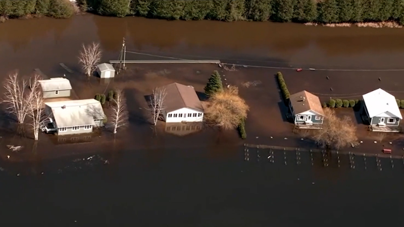
When Hurricane Dorian stalled over the Bahamas, it led to “unprecedented devastation” according to one official, the destruction of more than 13,000 homes, according to the Red Cross, and at least one confirmed death.
States of emergency have been declared along the Atlantic coast of the southeastern United States with Dorian forecast to track slowly up the coast throughout the week. It may even graze part of the northeastern United States over the weekend.
Before making landfall as a monstrous Category 5 hurricane, Dorian tracked over the Lesser Antilles as a tropical depression, shifted northward, became a tropical storm and then evolved into a well-defined hurricane just north of Puerto Rico.
For the latest live updates on Dorian, click here.
8:02 a.m. EDT Monday
Hurricane Dorian has continued to stall over Grand Bahama Island, dumping heavy rainfall on the area and staying steady in its slow progress. At the latest report, the maximum sustained winds are at 165 mph with hurricane-force winds extending 45 miles outward from the center. A storm surge warning remains in place for the next 36 hours.
According to authorities and Red Cross officials, Dorian has damaged as many as 13,000 houses. The extensive flooding on the island is believed to have contaminated wells with saltwater.
4 a.m. EDT Monday
The latest National Hurricane Center's update to Dorian states that the hurricane has nearly stalled out over Grand Bahama Island. Currently, it's tracking to the west at just 1 mph. The storm currently resides about 40 miles to the east of Freeport and 125 miles east of West Palm Beach, Florida. Due to some frictional effects of the Bahamian Islands, the hurricane now has top sustained winds of 165 mph, keeping category 5 status.
3 a.m. EDT Monday
As Dorian continues to inundate Grand Bahama Island, the Bahamas Press has reported that the Grand Bahama International Airport is now under 5 feet of water. At this time, the airport is in the midst of the outer eye wall, with the worst of the weather still yet to come.
2 a.m. EDT Monday
The National Hurricane Center's 2 a.m. advisory still keeps Dorian a powerful Category 5 hurricane with top sustained winds of 175 mph. Dorian continues to crawl to the west at a mere 5 mph.
1 a.m. EDT Monday
The eye of Dorian continues to track right over Grand Bahama Island, bringing the worst conditions in the eye wall to the entire area. Citizens have been urged to not leave their shelter when the eye passes overhead. Although the eye is tracking over land, Dorian remains a Category 5 hurricane.
12 a.m. EDT Monday
Late Sunday night, the first recorded death in Abaco following Hurricane Dorian was confirmed. Seven-year-old Lachino Mcintosh drowned, and his sister remains missing, according to the Bahamas Press. His death occurred after his family attempted to relocate their home.
11 p.m. EDT Sunday:
Hurricane Dorian made a third landfall on the eastern end of Grand Bahama Island, its maximum sustained winds dropping to 180 mph, though remaining a Category 5 storm. The hurricane continues to chug along at 6 mph as Florida continues to feel the outer bands of the storm.
"Time is running out across Florida for any last minute preparations as Hurricane Dorian continues to creep westward across the Bahamas Sunday night," AccuWeather Meteorologist Brandon Buckingham warned. "The first of the outer bands of the hurricane have already tracked into Florida's Atlantic coast, bringing along tropical downpours and some gusty winds. This is just a precursor of what is to come for the area."
As of late Sunday night, over 1,000 flights scheduled for Monday involving airports in Florida have been canceled, according to FlightAware.
10 p.m. EDT Sunday:
Georgia Gov. Brian Kemp ordered a mandatory evacuation for six counties east of I-95 due to Hurricane Dorian.
Dorian began to cross eastern Grand Bahama with maximum sustained winds of 185 mph, only 60 miles east of Freeport in Grand Bahama.
9:30 p.m. EDT Sunday:
Over 700 flights scheduled for Monday involving airports in Florida have been canceled, according to FlightAware. As of Sunday evening, the number sits around 736 flights.
The airports involved include Fort Lauderdale, Orlando, Palm Beach, Orlando Sanford, Miami and Hartsfield-Jackson. Fort Lauderdale has canceled about 263 flights, and Orland has canceled about 232 flights.
The Fort Lauderdale-Hollywood International Airport will join the list of airports closing on Monday in preparation for Dorian.
7 p.m. EDT Sunday:
South Carolina Gov. Henry McMaster ordered mandatory evacuations for coastal counties starting Monday, Sept. 2, at noon. On Tuesday, all schools and government offices across at least eight counties in the state will be closed.
6 p.m. EDT Sunday:
Ahead of Dorian reaching the U.S. southeastern coast, airlines are canceling flights and West Palm Airport in Florida plans to close on Monday at 2 a.m., EDT, and reopen Tuesday at 11 a.m., EDT.
5 p.m. EDT Sunday:
Brevard County, Florida, is now under a hurricane warning, meaning hurricane conditions are expected within the next 36 hours.
The full extent of the damage in the Bahamas is currently unknown, though there have been videos surfacing on social media of the insides of homes gutted, boats overturned in a sea of storm surge and houses with collapsed roofs after enduring one of the strongest storms of the Atlantic basin.
"I have seen utter devastation here in Marsh Harbour. We are surrounded by water with no way out," ABC News correspondent Marcus Moore told the news station. "Absolution devastation, there really are no words it is pure hell here on Marsh Harbour on Avoca Island in the northern part of the Bahamas."
The National Hurricane Center estimated storm surge to be 18 to 23 feet above normal tide levels.
The damage looks akin to the wreckage left behind from a powerful tornado. Construction trucks are shown being employed in rescue operations. Photos from before the storm showed people hunkered down in churches, waiting for the worst to hit.
4 p.m. EDT Sunday:
Dorian continues to barrel across the northern Bahamas with maximum sustained winds holding at 185 mph. Storm surge is greater than 20 feet above normal tide levels in the hardest-hit areas, according the the National Hurricane Center.
Lightning has also continued in the eye of the hurricane, a signal that the storm may still be strengthening.
While the Bahamas are being battered by Dorian, people across eastern Florida are making their final preparations before the arrival of gusty winds and heavy rain from the storm. This includes placing sandbags and locking bridges and flood gates near the coast.
2 p.m. EDT Sunday:
The eye of Dorian made a second landfall on Great Abaco Island near Marsh Harbour in the Bahamas. Maximum sustained winds were 185-mph during landfall.
According to the National Hurricane Center, this is tied for the strongest Atlantic hurricane landfall on record with the 1935 Labor Day hurricane.
1:30 p.m. EDT Sunday:
Florida Gov. Ron DeSantis is suspending tolls ahead of Dorian.
St. Johns County in St. Augustine, Florida has issued mandatory evacuation orders effective on 8 a.m. EDT Monday.
12:30 p.m. EDT Sunday:
Hurricane Dorian has made landfall with sustained surface winds of 185-mph at Elbow Cay, Abacos in the Bahamas.
Only one in the history of the Atlantic has achieved stronger top wind speeds than 185-mph, which was Hurricane Allen in 1980 packing 190-mph winds.


11 a.m. EDT Sunday:
Dorian is located about 205 miles east of West Palm Beach, Florida, and 20 miles east of Great Abaco island in the Bahamas. The hurricane has intensified and now has sustained winds of 180-mph, a dangerous Category 5.
Now at 180-mph, only four storms in the Atlantic have ever exceeded this wind speed, and only one since 2000, which was Wilma.
The outer rain bands of Dorian are moving over Great Abaco Island, and conditions will only get worse through the day Sunday and Monday.
Dorian is expected to slow its forward speed and turn north near or just offshore of Florida, Monday and Tuesday as a very damaging major Category 4 hurricane, with maximum sustained winds of at least 130 mph, if not higher.
10 a.m. EDT Sunday:
Dorian is closing in on Great Abaco Island, including Marsh Harbour and Hope Town. The Category 5 hurricane is still producing wind gusts well over 200-mph, similar to an EF4 tornado.
9 a.m. EDT Sunday:
Dorian has sustained winds of 175-mph with wind gusts over 200-mph. According to the NHC, these extreme winds will continue for the next several hours. This puts Dorian in the top three Atlantic sustained winds storms. Since 2000 in the Atlantic, only Rita, Wilma, and Irma had higher sustained winds.
8 a.m. EDT Sunday:
Dorian is now a Category 5 hurricane, located about 225 miles east of West Palm Beach, Florida; 35 miles east of Great Abaco island in the Bahamas; was packing winds of 160 mph with higher gusts and was moving west at 8 mph.

(Image via the Bahamas Department of Meteorology)
AccuWeather meteorologists pointed out satellite images of Dorian still portray the hurricane as a relatively small feature. Hurricane-force winds only extend outward from the hurricane by about 30 miles, while tropical storm-force winds extend outward from the center of the hurricane by about 105 miles. This is roughly half of what is average for a hurricane.
7 a.m. EDT Sunday:
Tropical storm warnings have now been issued for portions of Florida's east coast. A tropical storm warning is now in effect for north of Deerfield Beach to Sebastian Inlet, Florida, as well as north of Golden Beach to Deerfield Beach.
Dorian maintained Category 4 intensity overnight with maximum sustained winds of 150 mph.
6 a.m. EDT Sunday:
Dorian is located about 70 miles east of Great Abaco Island in the Bahamas.
Conditions will be deteriorating over the Abaco Islands during the next several hours, and then Grand Bahama Island later today, the National Hurricane Center said in a twitter post.
The storm's path has triggered Florida, Georgia, South Carolina and North Carolina to declare a state of emergency ahead of landfall.
5 a.m. EDT Sunday:
Dorian is about 255 miles east of West Palm Beach, Florida, and crawling closer at the sluggish pace of 8 mph. The storm maintains its Category 4 status with maximum sustained winds of 150 mph.
Additional reporting by Chaffin Mitchell, Adriana Navarro and AccuWeather Staff Members
Report a Typo


