All My Hurricane Rita Blogs
This blog entry contains 26 blog entries that I wrote about Hurricane Rita in 2005, all on one page. Each entry was originally a blog entry found at "Community.AccuWeather.com" where I had just started as the first weather blogger on AccuWeather.com. A screenshot of my blog on September 19, 2005 is shown below.

Like Katrina, AccuWeather also covered this storm live from Texas. You may also be interested in AccuWeather's live video coverage of the storm and b-roll comp from Hurricane Rita. I also have 2 hours of Hurricane Rita live TV coverage below.
BLOG NOTES: Times are in the UTC/GMT time zone, so subtract 5 hours for the local time on the East Coast where I was writing from. Most links no longer work and some images are missing.
=====================================================
Tropical Depression #17 Forms
September 17, 2005 2:41 pm
8:25 a.m... The government's National Hurricane Center says in a super-secret Tropical Disturbance statement that Tropical Depression # 17 is a done deal, but they aren't issuing advisories until 11 a.m.:
"...SEVENTEENTH TROPICAL DEPRESSION OF THE SEASON FORMING EAST OF THE WINDWARD ISLANDS... SATELLITE IMAGERY THIS MORNING INDICATES THAT THE VIGOROUS TROPICAL WAVE ABOUT 370 MILES EAST OF BARBADOS HAS BECOME BETTER ORGANIZED AND THAT A TROPICAL DEPRESSION IS FORMING..."
https://cms.accuweather.com/wp-content/uploads/2005/09/17-1.gif
That's the one just to the east of the Windward Islands on our satellite.
DEFINITION: Windward vs. Leeward Islands vs. Greater vs. Lesser Antilles
=====================================================
Powerful Rita Bound for Gulf
September 19, 2005 8:08 pm
Powerful Rita, nearly a hurricane early this afternoon, seems destined for the Gulf. On the way she'll hit Key West and may give our old friend the Dry Tortugas (who just reopened) a visit. After that, hard to say, but current predictions bring her into Texas.

Right now you can see Tropical Storm Rita on the Bahamas Radar or the South Florida radar. The storm is depicted well on our South Florida satellite. Don't rely on me to tell you the latest -- just check the AccuWeather.com home page or Hurricane Center.
She's a ways off yet but as Carl points out, it's time to start thinking about which webcams in Key West we'll observe.
I should also point out what Carl already did, which is that our own Hurricane Expert Joe Bastardi predicted this:
Interestingly, J.B. had predicted 7 named storms between Aug. 20 and Sep. 20. Should Rita get named in the next two days, he will have hit 7.
A small portion of J.B.'s column is available for free for the rest of season. To get the full column, you'll need to sign up for a 30-day trial of AccuWeather.com Professional.
=====================================================
Rita Recon She's A Hurricane
September 20, 2005 3:18 pm
UPDATE: 1:15 PM Eastern:
More recon data is in, indicating that Rita has 100 mph winds at the surface (so she's a Cat 2).
I spent some time yesterday writing a decoding program for the reconnaissance data from government planes flying into Rita.
When they fly the planes in, they transmit a set of data every few minutes, which contains data measured every 30 seconds. This data is now available on AccuWeather.com, Premium, and Professional, as well as WeatherMatrix.

The automated output from the recon decoding currently shows:
10:00 AM: During reconnaissance of tropical system RITA a maximum sustained wind speed of 90 mph at 9978 feet, and a maximum wind gust of 92 mph at 9978 feet, were found by the government plane.
A little earlier, they had found hurricane-force winds lower, which translated to hurricane-force winds at the surface, causing the government's National Hurricane Center to upgrade Rita to a hurricane. For this translation, they estimate based on a number of factors including storm size and pressure gradient.
Because I'm so busy I'm brainless, I didn't start archiving the data until just now.
=====================================================
Hurricane Rita Bops Buoys
September 20, 2005 8:58 pm
Hurricane Rita, currently just south of the western extent of Key West, is now packing winds of over 100 mph. A couple of buoys have had close calls. SMKF1 (CURRENT | ARCHIVED) reported a wind gust to 78 mph; both SANF1 (CURRENT | ARCHIVED) and FWFY1 (CURRENT | ARCHIVED) reported around 65 mph gusts.

Something else Rita might bop is a few oil and gas fields. Even without a direct hit, more oil rigs could sustain damage, as they did during Katrina, and this has already had some negative effects on the market.

=====================================================
Rita Update + Oil Rig Cam
September 21, 2005 2:06 am
RITA UPDATE: 00Z Wednesday (8 p.m. Tuesday): Buoy SANF1 (CURRENT | ARCHIVED) recently reported a gust of 79 mph as it passed through the eyewall. Also the government's National Hurricane Center reports: "AN UNOFFICIAL REPORT FROM A HAM RADIO OPERATOR INDICATED SUSTAINED WINDS OF 75 MPH WITH GUSTS TO 102 MPH WERE MEASURED BY WIND EQUIPMENT IN THE KEY WEST AREA."
The NHC also says: "RITA WILL PASS CLOSE ENOUGH FOR THE NORTHERN PORTION OF THE EYEWALL TO MOVE OVER OR JUST SOUTH OF THE DRY TORTUGAS." That means that we'll be seeing some action soon on DRYF1 (CURRENT | ARCHIVED), the buoy near the Dry Tortugas (see previous blog postings on them). In fact at 8 p.m. it's already gusting to 64 mph with pressure plummeting.
I have to give credit to Carl for stumbling onto this one: One of the oil rigs in the Gulf (that just happens to be in the path of Hurricane Rita) has a webcam running on it. Can you believe that? Below is a sample image, click on it to see the real thing.

Interestingly enough, it isn't the only one. There's an oil rig cam off the shore of the U.K.. There used to be one here off the coast of Maine but it doesn't appear to be working anymore.
Equally as hard and expensive to operate, but much less likely to be found in the path of a hurricane, are the more popular Cruise Ship Bridge Cams.
I'm a huge weather cam / webcam fan, always have been. It probably comes from running one of the first personal cams on the net back in '95 and having run weather cams at my house for 8 years.
I think there should be a weather camera on every corner.
This year I even ran an experimental wireless (PDA) cam in the car on vacation and a wireless laptop cam while I was on vacation. I've even envisioned a Cat Cam and a Hat Cam (as of yet, I haven't had time to work on them).
=====================================================
Morning Update - Rita Cat 4
September 21, 2005 12:58 pm
8 a.m. here on the East Coast and Rita is a Cat 4 this morning. Dry tortugas is gusting to 75 mph in the back eyewall.
https://cms.accuweather.com/wp-content/uploads/2005/09/isese-1.jpg
For those of you who caught my early morning typo, no I haven't transported us all back one month ago, this is in fact, NOT Katrina but rather Rita :) no I haven't transported us all back one month ago, this is in fact, NOT Katrina but rather Rita :)
=====================================================
Rita - A Strong and Beautiful Storm
September 21, 2005 7:12 pm
Hurricane Rita has that classic strong hurricane look on today's satellite images. She is now a Category 5 (165 mph sustained winds) with little to slow her down or weaken her in the Gulf, with one possible exception - there is a spot where there is a lack of tropical cyclone heat potential in her path. She knocked out the Dry Tortugas Buoy, which hasn't reported since early this morning (when it had 75 mph wind gusts). The central Gulf doesn't have much for weather observations... probably 42001 (in the central Gulf) is the next one to look at... it was reporting waves rising from 3 feet yesterday to over 10 feet already today.

The FGBL1 Oil Rig Cam (off the coast of Galveston) is still up and going, even though the news says that the rigs were evacuated this morning. Oil prices rose on this news, even though Rita is days away from the nearest oil field.
Just for fun I had the boys downstairs draw up a map showing all tropical storms that have passed through Rita's current position. That map is shown below. As the tracks cross, the colors increase. In theory, it would be almost impossible for a storm in that position to move southwest at this point. Equally unlikely would be a Brownsville, TX or Mexico hit. But does this graphic really tell us the whole story? We only have Tropical Storm records back about 150 years. If we had a thousand years, that would be much more useful, but for now we've got to work with what data we have. Right now the forecast model predictions and upper-level atmospheric patterns are more important, and they are still foretelling of a hit somewhere on the central Texas coast.

=====================================================
Rita LBAR, A98E, BAMM, GFDL?
September 21, 2005 8:10 pm
A reader had some questions today about the weather forecast models from which we show forecast hurricane tracks on our Professional site. Below is an example of the storm tracks from this afternoon:

HURRICANE RITA MODEL TRACKS 9/21 Afternoon
All of these tracks are from government-run weather prediction models which are geared specifically to tracking tropical systems. With the exception of the GFDL, all models are two-dimensional, predicting a storm's track only.
Here's what the abbreviations mean:
A98E - National Hurricane Center Atlantic 1998 Early Model
BAMM - Beta and Advection Model (Medium Layer)
BAMD - Beta and Advection Model (Deep Layer)
LBAR - Limited Area Barotropic Model
GFDL - Geophysical Fluid Dynamics Laboratory Model
Which model does the best? It depends on who you ask :) Like other meteorological models, each seems to forecast better in certain situations. Notice that today's tracks are converged on the central Texas coastline which makes meteorologists feel confident about the forecast that we are issuing today. Should these tracks begin to diverge with different landfalls, the forecast will be more risky.
I don't want to get too geeky here, but some (admittedly dated) verification statistics and advanced descriptions of the models are available here, if you are interested. Although the ones above are the most popular models, there are actually over 30 models that forecast tropical tracks, and we are working to get all of them on our website.
Here's a brief description of the ones on our Pro site:
A98E - A statistical track model which looks at past storms which formed in the same place, and mixes this forecast with upper-level forecast model data from the GFS. Storms are classified based on location and movement, then specific meteorological equations are applied.
BAMM/BAMD - A track model which uses an altered version of forecast model data from the GFS with special meteorological equations that predict the evolution of tropical storms, including taking into account the "beta effect" of the earth's rotation. The BAMD uses an average of winds over the entire atmosphere from top to bottom (good for big storms), while the BAMM uses a medium vertical average (good for medium storms). There is also a BAMS (shallow) for small storms.
LBAR - A an altered version of forecast model data from the GFS with special meteorological equations and techniques (different from the BAM), including an average of winds over the entire atmosphere from top to bottom, that predict the evolution of tropical storms.
GFDL - An advanced 3-dimensional weather forecast model developed specifically for predicting hurricane movement. It includes 18 levels of the atmosphere and 3 nested grids (resolutions). It includes special meteorological equations and techniques for forming storms but obtains its initial conditions from the GFS.
=====================================================
Rita 3rd Strongest Ever
September 21, 2005 11:59 pm
UPDATE: 8:15 p.m.
Tonight, Rita takes her place tonight as the 3rd most intense hurricane on record in the Atlantic. Here's the new listing:
898 mb : Rita '05
892 mb : Unnamed '35*
888 mb : Gilbert '88
Buoy 42001, hundreds of miles in front of the storm, reported waves over 21 feet before falling silent this evening. Other buoys closer to the Gulf Coast are already seeing 10 foot waves.

*The 892 mb reading, incredibly, is at landfall. That's incredible because hurricanes rarely maintain their strength near landfall. It's not incredible that it was only measured at landfall, cause they didn't have planes flying into storms back then :)
=====================================================
Two Cat Fives So Close Together?
September 22, 2005 3:27 pm
A reader and old buddy of mine from elementary school wrote last night:
It goes without saying that Hurricane Rita is yet another powerful storm. Is this the first time 2 Category 5 storms have culminated in such a short time frame (3 weeks)?
I had to do a little research, but it looks like it only happened once before, in 1960. That year, Hurricane Donna hit Cat 5 status on September 4th, then Ethel closely followed on September 15th. The magenta color on the maps below shows where they obtained Cat 5 status.


You can see a complete list of Atlantic Category 5 storms below.
This is also only the third year on record with two Category 5 storms at any time in the same year (1961 had one in September and October).
=====================================================
42001, We Hardly Knew Ye
September 22, 2005 10:02 pm
A quick afternoon update on Hurricane Rita.
First, its important to note that tracks are trending to the northeast. (Keep an eye on the AccuWeather track in the lower left-hand corner of this blog).
Next, Buoy 42001 in the central Gulf is now nearing the eye of the hurricane. It's showing winds over 110 mph and pressure plummeting to 28.40 inches (at a rate of 0.70 per hour; a "rapid fall" is considered more than 0.03 per hour!) Waves are reading 35 feet. This may be the most impressive buoy readings that I have seen this year. I can't imagine the buoy will hang in there much longer. Even more incredible (since the storm is in the middle of the Gulf), wave heights are between 10 and 20 feet just off the coast of the Deep South.

Next, two million people are running out of gas in traffic jams trying to get out of Houston, clogging roads 100 miles outside of the city. Check out this news article, our own Penstone's blog & videos, and also Carl's blog, on the traffic situation in Houston. You can see weather and traffic cams from Texas on the WeatherMatrix site.

And finally, watch some of my cohorts tonight on the news for more of an updated, expert view than I can provide you here:
8:00 pm EDT- Bernie Rayno on Fox with O'Reilly
8:00 pm EDT- Jim Kosek on CNN Headline News with Nancy Grace
9:00 pm EDT- Joe Bastardi on Fox with Hannity and Colmes
9:00 pm EDT- Ken Reeves on CNN with Larry King Live
=====================================================
Central Gulf Buoy - 38 Feet, 121 MPH
September 23, 2005 1:45 am
UPDATE TO BUOY 41002, We Hardly Knew Ye":
Buoy 42001 in the central Gulf is has passed through the eyewall and is now coming out the other side. The National Buoy Data Center says that 42001 has broken from its moorings and is now adrift (but still reporting weather data). It showed winds over 120 mph and pressure plummeting to an incredible 27.34 inches of mercury (at a rate of 1.40 inches per hour; a "rapid fall" is considered more than 0.03 per hour!) Waves are reading 38 feet. These readings sound similar to buoy readings during Katrina but I'll have to do some research this weekend to find out which one wins out.
=====================================================
Grim News Friday Morning
September 23, 2005 3:14 pm
The news this morning is grim and I hesitate to even report it, but reporting weather-related news is what I do.
For one, water is cascading over a levee in New Orleans (again) due to storm surge and rainfall from Rita. The hurricane is simply so large that a storm surge of several feet has already reached Lake Ponchartrain. Rainfall was less than an inch over much of the city, but a heavy thunderstorm associated with one of Rita's bands dropped 2 to 4 inches of rain over a narrow area of the city (see Doppler-estimated precip map below from AccuWeather.com RadarPlus).


Traffic continued to be backed up for over 100 miles overnight and KPRC reported that people were still stranded on highways this morning, out of gas or waiting in line for gas. KPRC reports that one elderly woman was killed in a slip and fall accident at a gas station while waiting for gas overnight.
Worse, a bus carrying elderly evacuees from Hurricane Rita exploded this morning south of Dallas this morning, killing 24 people.
The Houston mayor warned this morning on KPRC that it was too late to evacuate now and people should instead seek shelter today.
Click here to hear and see local scanner, television, and radio feeds.

Now for the grim weather news. We could bet setting up for a massive flooding situation in Texas. Looking at the color water vapor image above, the ridge of high pressure (orange = dry air / high pressure) north of the storm is what will determine Rita's future. There is a fear that, rather than getting caught in the gears and moving quickly to the northeast after landfall, Rita could get stuck under the ridge and meander around in Texas for days, dumping massive amounts of rain. When Tropical Storm Allison did this in 2001, over 3 feet of rain was recorded in Houston.
More on this, including maps, will be posted later today.
=====================================================
Massive Flooding Threat With Rita
September 23, 2005 7:57 pm
Hurricane Rita has been downgraded to a Category 3 storm, but is still very dangerous. I talked a little bit earlier about how a big threat from Hurricane Rita could be massive flooding in easternmost Texas and Louisiana. I wanted to explain a little more why AccuWeather's meteorologists are worried about this.

The latest forecast tracks from 35 computer forecast models are shown above (see my Hurricane Forecast Model tutorial). Notice that several models are taking Rita in a loop pattern. This would keep the area under heavy rain for several days. Below is our latest rainfall forecast map for the area, which is conservative... some of our meteorologists are calling for a maximum of 30 inches of rain in the hardest hit areas. The government is also on task calling for up to 25 inches.

I also had mentioned in the last post Tropical Storm Allison in 2001. I was writing the weather headlines for AccuWeather.com that week and I remember seeing the amazing 36" rainfall amounts show up on our maps (one of which is below). You can also see Allison's track map here. A repeat of Allison is what we are fearing at this time.

=====================================================
Winds Gust to 94 MPH With Rita
September 24, 2005 4:14 am
BREAKING NEWS 11:30 PM: Large fire in downtown Galveston being fanned by 70 mph winds. Incredible on-air footage on CNN, online story here.
AS OF 11 PM EASTERN TIME:
MRSL1 - Marsh Island, LA: 94 mph
CAPL1 - Calcasieu Pass, LA: 90 mph
CLCL1 - Cameron, LA: 87 mph
SPLL1 - South Timbalier Block 52, LA: 79 mph
Salt Point, LA: 74 mph
Sabine Pass, TX: 73 mph
ILDL1 - Isle Dernieres, LA: 73 mph
Lake Charles, LA: 71 mph
LACL1 - Lacassine, LA: 71 mph
SRST2 - Sabine, TX: 70 mph
We won't know for sure how bad things are until the morning's light. You can see streaming video from Houston TV and streaming audio from local radio and scanners at this site.

=====================================================
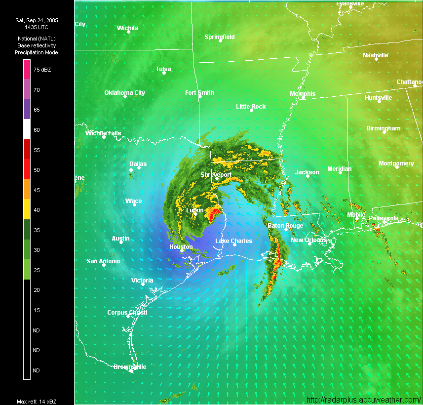
Rita Damage & Wind Gust Reports
September 24, 2005 3:24 pm
UPDATE 4 PM EASTERN: Added a few new News Reports links to the bottom of the list.
Here's what we know about Hurricane Rita's landfall as of noon Saturday.
Rita made landfall at 3:40 a.m. EST with the storm's eye hitting just east of Sabine Pass, Tex., about 32 miles southeast of Beaumont. It is now located east of Lufkin, Texas, as shown by AccuWeather.com RadarPlus below.

Both government radars in the area, at Polk Airforce Base & Lake Charles, were knocked out overnight.
LATEST WIND GUST REPORTS:
Lake Livingston, TX: 117 mph (Dam Operator)
CAPL1 - Calcasieu Pass, LA: 112 mph
Port Arthur, TX: 116 mph (CNN)
CLCL1 - Cameron, LA: 108 mph
Beaumont, TX: 105 mph
CAPL1 - Calcasieu Pass, LA: 101 mph
Sea Rim State Park, TX: 101 mph (AccuWeather)
SRST2 - Sabine, TX: 99 mph
MRSL1 - Marsh Island, LA: 93 mph
Lake Charles, LA: 86 mph (NWS)
Jasper, LA: 85 mph (Ham Radio Operator)
Lake Charles, LA: 74 mph
SPLL1 - South Timbalier Block 52, LA: 79 mph
Sabine Pass, TX: 79 mph
Salt Point, LA: 74 mph
42035 - Galveston Buoy, TX: 76 mph
ILDL1 - Isle Dernieres, LA: 73 mph
LACL1 - Lacassine, LA: 71 mph
NEWS REPORTS:
Lake Charles levee breach (ABC13)
Building collapse in downtown Beaumont (KPRC)
Port Arthur cargo ship knocked off moorings (FOXNEWS)
Over 1,000,000 customers without power in Texas (Various)
Jasper: Various fires, house floating down street, people inside (KHOU)
Possible looting in Beaumont, TX (KHOU)
Major structural damage to a hotel in Beaumont (KHOU)
Part of terminal building at Lake Charles destroyed (KHOU)
Galveston County Daily News lost part of its roof (KTRK)
The Police department in Woodville lost its roof (KTRK)
Fires in Spring and Pasadena (KHOU)
Junior high school in Warren lost roof (KPRC)
Houston refineries undamaged (AccuWeather.com)
I-10 Overpass collapsed (KHOU)
Port Arthur refinery damaged (CNN)
Jefferson County apartment building collapse (CNN)
Nearly 1,500,000 customers without power [including Katrina victims] (CNN)
City-by-city damage report (Nearly 1,500,000 customers without power [including Katrina victims]) (CNN)
KHOU, a large television station in Houston, went off the air around 1 p.m.
More news and amateur photo galleries are available from local websites such as KTRK and KHOU, and KPRC. You can watch live streaming video from these stations and listen to other live audio feeds on this website.
EARLY MORNING RAINFALL REPORTS:*
Beaumont-Port Arthur, Texas : 8.04 inches
Baton Rouge, Louisiana : 7.29 inches
*These rainfall reports have been superceded by a final report.
Doppler radar indicates that 12 to 16 inches of rain fell in easternmost Texas and western Louisiana. New Orleans dodged the bullet receiving little rain at all, though the 8 inch line was just west of town (see first image below, New Orleans is at the X). Below are screen captures from AccuWeather.com RadarPlus showing the heavy rainfall estimates from Doppler radar, zoomed in on New Orleans then on Lake Charles, LA.
Now, we have to worry about how much more rain will fall. As we talked about yesterday, the AccuWeather.com track now shows Rita meandering in the Louisiana area for a week -- the state may be mostly under water by then.


=====================================================
Tornadoes In MS; Lake Charles Floods
September 24, 2005 10:11 pm
The government has issued a Tornado Watch for Mississippi today as severe thunderstorms and tornadoes break out east of Tropical Storm Rita.
A tornado was reported on the ground near Greenville, Mississippi at 4 p.m. Eastern.
Below is a radar image from 4:45 pm eastern, courtesy NOAA.

Shown below are lightning strikes (yellow and white), tornado warnings (red), severe thunderstorm warnings (yellow), and tagged severe storms (red triangles = tornadic signatures, green boxes = rotation, blue circles = hail). Radar image (zoomed in near Yazoo, Mississippi) courtesy AccuWeather.com RadarPlus.

You can see current watches and warnings in Mississippi on AccuWeather.com's Severe Weather Center.
It is unclear from media reports how much flooding is occurring in the city of Lake Charles, Louisiana today, but the government's flood information paints a grim picture. Their report for the Calcasieu River at Saltwater Barrier indicated that the forecast stage on the river was 12.5 feet today. According to NOAA, this would cause "major flooding of residential areas, marshlands, recreational camps, access roads, and river front areas." This would be near the record stage, which is 13 feet, at which point "over half of the city of Lake Charles would be flooded."
As far as official news reports, FoxNews says on-air at 5:30 p.m. Eastern) that they are trying to get a camera crew into the town of Lake Charles to provide footage, but are having trouble getting around all the downed trees. The Statesman reported that "extensive flooding" was occurring and water was "waist deep" in some parts of town. The Courier Post has a photo of the park near the shore completely underwater with waves lapping against trees.
=====================================================
Rita To Turn Around, Go Back to Gulf?
September 25, 2005 4:08 am
NOTE: This report has been superseded with additional clarification in my new blog entry below "Clarification of Rita Movement".
This is probably the most bizarre hurricane forecast I have ever seen AccuWeather put out, so I had to document it here. Not that there's anything wrong with this forecast, but only in a year that threatens to break the record of overall tropical storms and category five storms, would you ever see this:

That's right, Rita is projected to turn around, move over the area hit hardest by Hurricane Katrina, nearing New Orleans, and go back into the Gulf of Mexico, my friends. Sound unbelievable? Nobody believed AccuWeather.com Professional's Joe Bastardi either last year when he called for Hurricane Ivan to exit the east coast, turn around and go back into the Gulf.

Could we be wrong? Absolutely, that's the nature of forecasting. But right now looking at all the data, this is our best guess. Show me a forecaster who's always right, I'll sell you some oceanfront property in Wyoming.
=====================================================
21 Tornado Reports, 1 Fatality In MS
September 25, 2005 4:13 am
UPDATED AT 9 PM EDT SATURDAY (02Z SUNDAY)

21 tornado reports were received by the government's National Weather Service this Saturday afternoon in Mississippi and Arkansas, as a result of storms moving outwards from Tropical Storm Rita in east Texas. Many of the tornadoes or funnel clouds were spotted or photographed by locals. One fatality occurred in Humphreys County, in Belzoni, MS this afternoon during a tornado. Major damage was also reported at the Jockey Manufacturing plant in Belzoni.
The image below from AccuWeather.com RadarPlus shows tornadic signatures on radar just before the storm produced the tornado in Belzoni.

Radar movies from today are available here.
=====================================================
Hurricane Rita Rainfall Totals
September 25, 2005 2:47 pm
This was amended from an earlier report.

The following are official rainfall totals (over 7 inches) as reported by the government's Hydrological Prediction Center:
LAPLACE,LA: 12.4"
BUNKIE,LA: 10.0"
BATON ROUGE, LA: 9.4"
JENNINGS,LA: 9.4"
BEAUMONT/PORT ARTHUR, TX: 8.6"
CENTER, TX: 8.5"
PORT VINCENT, LA: 8.1"
MILLERVILLE, LA: 8.1"
INNISWOLD, LA: 7.3"
Doppler radar estimates showed over 12" of rain falling in some areas. The AccuWeather.com Doppler Precipitation Estimate Composite (for 24 hours of rain) is shown above. Below is shown the total radar estimate from the Lake Charles radar (which was not in service during the entire storm). This image is courtesy AccuWeather.com RadarPlus.

=====================================================
Tornadoes Sunday in Deep South
September 25, 2005 8:37 pm
More tornadoes and severe thunderstorms are breaking out this Sunday from the remnants of Hurricane Rita, as happened yesterday. As of 3:30 EDT, only one tornado has been reported but nearly 70 Tornado Warnings have been issued today and two Tornado Watches are in effect. Below is a maps showing the radar and advisories as of 3:15 EDT, courtesy NOAA. NOAA said at 2:30 EDT: "POTENTIALLY TORNADIC SUPERCELLS MAY AFFECT BIRMINGHAM AND HUNTSVILLE VICINITIES WITHIN NEXT THE 2-3 HOURS."

Keep up with today's severe weather by accessing the AccuWeather.com Severe Weather Center. Radars to watch are Birmingham and Huntsville.
=====================================================
Oppressive Heat/Humidity in LA, TX
September 25, 2005 10:15 pm
One thing that people in Texas and Louisiana don't need today, as they cleanup from Hurricane Rita, is heat and humidity. Unfortunately, it is oppressive there today.
Low temperatures overnight in most of the area were in the 80s. Temperatures today have been over 100 degrees in Texas, except the recovery area which has been mostly in the 90s. However, Heat Index readings have been as high as 115 in the areas hardest hit by Hurricane Rita.

=====================================================
Tornado Update - MSU Hit
September 25, 2005 11:53 pm
23 tornadoes have been reported today in the Deep South as the remnants of Hurricane Rita move northeastward. The radar image below (from AccuWeather.com RadarPlus) shows five tornadic signatures on the radar at the same time. Movies of the severe storms on radar are available at this location.

A radar from 7:39 PM EDT showing the Tornado Watch areas is shown below, courtesy NOAA.

A tornado hit Mississippi State University shortly before 4 p.m. EDT this afternoon, injuring four people, according to Dr. Mike Brown, an Associate Professor of Meteorology at MSU, who reported this to the National Weather Service.
=====================================================
Dreary or Welcome? Rita Visits PA
September 26, 2005 8:19 pm
The dreary photo below is brought to you by the remnants of Hurricane Rita, which have hooked up with a cold front and brough Central Pennsylvania and AccuWeather HQ the first significant rainfall since the remnants of Hurricane Katrina spread over the area on August 30th.

For some, though, the rain is a welcome relief. We have been suffering under a short-term drought all summer and I haven't mowed my lawn for weeks (see depressing photos of my lawn).


=====================================================
Aerial Photos of Rita Released
September 26, 2005 9:36 pm
The government has released their aerial (satellite) photos from after Hurricane Rita (as they did with other storms this year).
The images of the worst hit areas are shocking. The towns of Cameron and Holly Beach, LA were decimated by the storm (CNN reports 90% of the houses destroyed) -- sample images are shown below.


=====================================================
Sweltering Heat in Recovery Area
September 26, 2005 10:34 pm
Yesterday's weather story is happening again today -- people in the area recovering from Hurricane Rita are being exposed to intense heat and humidity. Overnight low temperatures last night were the the 70s and 80s.

Heat Advisories

Heat Index At 4 PM CDT
The National Weather Service has issued Heat Advisories across southeastern Texas and southwestern Louisiana. Heat Index readings over 100 degrees cover the area this afternoon, with readings as high as 112 near Galveston, Texas. 1.3 million customers are still without power in the storm ravaged area, which means no chance for relief from air conditioning or fans.
Surface weather maps above courtesy AccuWeather.com Professional.
=====================================================
Mississippi State Tornado Photos
September 27, 2005 2:27 am

Mississippi State University has released photos on their website of the damage done there by the tornado that hit Sunday (see original report on this blog). Their report tells of an overturned RV, roofs torn off, and many large trees downed. At least a dozen mobile homes were heavily damaged or destroyed in a nearby trailer park. Fortunately, injuries were only minor. Ironically, Mississippi State is known for its broadcast meteorology and distance learning meteorology programs. Classes were cancelled on Monday.
The National Weather Service reports that this was an F1 tornado on the Fujita scale:
THIS TORNADO TOUCHED DOWN ON THE EASTERN EDGE OF THE SHERWOOD FOREST SUBDIVISION AND TRACKED NE FOR 3.5 MILES. THE TORNADO MOVED THROUGH THE MSU CAMPUS, UPROOTING SEVERAL TREES AND CAUSING SPORADIC DAMAGE TO UNIVERSITY BUILDINGS. MUCH OF THE DAMAGE WAS AT THE UNIVERSITY HILLS MOBILE HOME PARK, JUST PRIOR TO THE TORNADOS DISSIPATION NEAR US-82. ELEVEN MOBILE HOMES WERE DESTROYED, WITH NUMEROUS OTHER HOMES DAMAGED.
=====================================================
Report a Typo


