Southeast could pick up double the normal June rainfall in less than a week
By
Alex Sosnowski, AccuWeather senior meteorologist
Published Jun 12, 2020 3:02 PM EST
The forward progression of weather systems is forecast to grind to a halt, causing a swath of moisture to stall out along the southern Atlantic coast. The slug of moist air will fuel numerous showers and thunderstorms -- and the deluge could deliver over a foot of precipitation to some locations through the middle of next week.
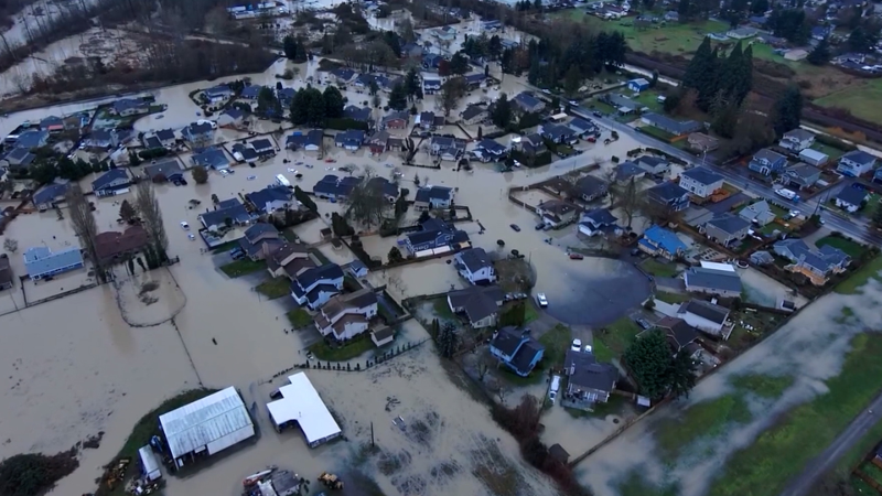
As rainfall ratchets up and downpours repeat over increasingly wet and then saturated ground, the risk of flooding may expand beyond urban and poor-drainage areas to small streams and perhaps along some of the major rivers in the region.
A band of clouds and moisture hovered along the southern Atlantic coast on Friday, June 12, 2020, as a large swath of dry air pushed over the Central and Northeastern states. (NOAA / GOES-East)
A trio of weather systems -- a cold front along the coast, a southward dip in the jet stream and an area of high pressure over the Atlantic -- will be the key players in the pattern. The front will provide a focal point for the downpours to erupt along as the high pressure system positioned well offshore will push moisture near the coast and the jet stream will draw the moisture inland.
Through the first part of the weekend, the bulk of the rain will tend to hover within 100 miles of the Carolina coast. But later in the weekend to the middle of next week, the downpour zone is likely to expand northwestward to the mountains of North Carolina, southern Virginia and southeastern West Virginia.
Even though it is common during the summer months for most showers and thunderstorms to occur inland of the beaches, thanks to a sea breeze, that probably will not be the case with this pattern. Beachgoers from North Carolina to Georgia and part of the Florida coast may be dodging frequent downpours and locally gusty winds through the weekend and into next week, thanks to a great deal of moisture being pumped in from the ocean.
A general 4-8 inches of rain is likely to fall near the coast with an AccuWeather Local StormMax™ of 12 inches. Some areas may pick up double the normal rainfall for the entire month of June, which generally ranges from 3.5 to 5.5 inches for the region.
From the Piedmont areas of the Carolinas and Virginia to the southern Appalachians, much less rain is forecast. A significant amount of rain may fall from Sunday to Monday over this interior zone from more spotty showers and thunderstorms.
Another pocket where multiple downpours and localized can occur this weekend to early next week is over South Florida. The downpours could pester NASCAR activities at Homestead, Florida, this weekend. Downpours in the vicinity could trigger delays for the Xfinity series race Saturday afternoon, the Gander RV and Outdoors truck series race Saturday evening and the Cup series race on Sunday.
Downpours visited Martinsville Speedway, Virginia, this past Wednesday, but managed to avoid the area during the evening race, which was completed as scheduled.
Stark contrast in weather for the northeastern US
There is some good news and some bad news for the Northeast due in part to a stark contrast in the weather pattern from north to south in the eastern part of the nation.
"North of the rain zone, the weather is likely to be spectacular this weekend," according to AccuWeather Meteorologist Courtney Travis.
"The rain will tend to consolidate over the Southeast states rather than spread northward through New England," she explained.
That will mean a dry weekend for most places from Pennsylvania and New Jersey to Maine with a couple of exceptions and an isolated shower or thunderstorm risk. But, the dry weather may not be welcomed by every part of the region.
"New England has been missing out on soaking rain in recent weeks and that now has the region abnormally dry," Travis said.
During the middle of June, the intense sunshine, with dry air and long days, can evaporate 0.25 to 0.50 of an inch of water from the soil.
The short-term dryness also extends across much of New York state and northern Pennsylvania.
"There is no sign of any big rain in the upper part of the mid-Atlantic states and New England through next week," she said.
Rainfall since May 1 has ranged from 40 to 60 percent of average in much of New England. Dryness has gotten more intense since the middle of May.
The dry weather has allowed construction projects to throttle up with few interruptions following COVID-19 restrictions from earlier this spring.
Those hoping to keep gardens growing and lawns green will need to water frequently in the dry pattern in the Northeast as lawns and gardens in the Southeast pick up plenty of water.
Bathers should exercise caution in Maryland, Delaware, southeastern Virginia and New Jersey this weekend. A quickening breeze from the northeast is likely to generate building waves and increasing rip currents. The onshore flow can also lead to minor coastal flooding in the Virginia Tidewater area.
Keep checking back on AccuWeather.com and stay tuned to the AccuWeather Network on DirecTV, Frontier and Verizon Fios.
Report a Typo


News / Severe Weather
Southeast could pick up double the normal June rainfall in less than a week
By Alex Sosnowski, AccuWeather senior meteorologist
Published Jun 12, 2020 3:02 PM EST
The forward progression of weather systems is forecast to grind to a halt, causing a swath of moisture to stall out along the southern Atlantic coast. The slug of moist air will fuel numerous showers and thunderstorms -- and the deluge could deliver over a foot of precipitation to some locations through the middle of next week.
As rainfall ratchets up and downpours repeat over increasingly wet and then saturated ground, the risk of flooding may expand beyond urban and poor-drainage areas to small streams and perhaps along some of the major rivers in the region.
A band of clouds and moisture hovered along the southern Atlantic coast on Friday, June 12, 2020, as a large swath of dry air pushed over the Central and Northeastern states. (NOAA / GOES-East)
A trio of weather systems -- a cold front along the coast, a southward dip in the jet stream and an area of high pressure over the Atlantic -- will be the key players in the pattern. The front will provide a focal point for the downpours to erupt along as the high pressure system positioned well offshore will push moisture near the coast and the jet stream will draw the moisture inland.
Through the first part of the weekend, the bulk of the rain will tend to hover within 100 miles of the Carolina coast. But later in the weekend to the middle of next week, the downpour zone is likely to expand northwestward to the mountains of North Carolina, southern Virginia and southeastern West Virginia.
Related:
Even though it is common during the summer months for most showers and thunderstorms to occur inland of the beaches, thanks to a sea breeze, that probably will not be the case with this pattern. Beachgoers from North Carolina to Georgia and part of the Florida coast may be dodging frequent downpours and locally gusty winds through the weekend and into next week, thanks to a great deal of moisture being pumped in from the ocean.
A general 4-8 inches of rain is likely to fall near the coast with an AccuWeather Local StormMax™ of 12 inches. Some areas may pick up double the normal rainfall for the entire month of June, which generally ranges from 3.5 to 5.5 inches for the region.
From the Piedmont areas of the Carolinas and Virginia to the southern Appalachians, much less rain is forecast. A significant amount of rain may fall from Sunday to Monday over this interior zone from more spotty showers and thunderstorms.
Another pocket where multiple downpours and localized can occur this weekend to early next week is over South Florida. The downpours could pester NASCAR activities at Homestead, Florida, this weekend. Downpours in the vicinity could trigger delays for the Xfinity series race Saturday afternoon, the Gander RV and Outdoors truck series race Saturday evening and the Cup series race on Sunday.
Downpours visited Martinsville Speedway, Virginia, this past Wednesday, but managed to avoid the area during the evening race, which was completed as scheduled.
Stark contrast in weather for the northeastern US
There is some good news and some bad news for the Northeast due in part to a stark contrast in the weather pattern from north to south in the eastern part of the nation.
"North of the rain zone, the weather is likely to be spectacular this weekend," according to AccuWeather Meteorologist Courtney Travis.
"The rain will tend to consolidate over the Southeast states rather than spread northward through New England," she explained.
That will mean a dry weekend for most places from Pennsylvania and New Jersey to Maine with a couple of exceptions and an isolated shower or thunderstorm risk. But, the dry weather may not be welcomed by every part of the region.
"New England has been missing out on soaking rain in recent weeks and that now has the region abnormally dry," Travis said.
During the middle of June, the intense sunshine, with dry air and long days, can evaporate 0.25 to 0.50 of an inch of water from the soil.
The short-term dryness also extends across much of New York state and northern Pennsylvania.
"There is no sign of any big rain in the upper part of the mid-Atlantic states and New England through next week," she said.
Rainfall since May 1 has ranged from 40 to 60 percent of average in much of New England. Dryness has gotten more intense since the middle of May.
The dry weather has allowed construction projects to throttle up with few interruptions following COVID-19 restrictions from earlier this spring.
Those hoping to keep gardens growing and lawns green will need to water frequently in the dry pattern in the Northeast as lawns and gardens in the Southeast pick up plenty of water.
Bathers should exercise caution in Maryland, Delaware, southeastern Virginia and New Jersey this weekend. A quickening breeze from the northeast is likely to generate building waves and increasing rip currents. The onshore flow can also lead to minor coastal flooding in the Virginia Tidewater area.
Keep checking back on AccuWeather.com and stay tuned to the AccuWeather Network on DirecTV, Frontier and Verizon Fios.
Report a Typo