Severe weather threat to rebound in central US
After a brief lull, portions of the Mississippi Valley and southern Plains will experience a new surge of severe weather on Thursday. Some strong storms are likely to press on to the Southeast states.
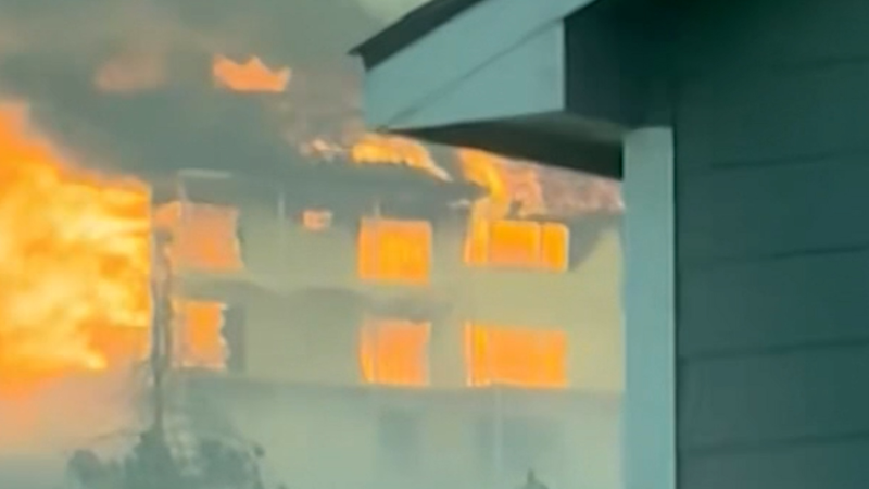
A line of severe thunderstorms cut through Ohio on April 17, striking communities throughout the state with intense weather.
Following thunderstorms with hail over parts of the central Plains late Wednesday night, the likelihood of severe thunderstorms will continue to shift eastward and southward into Thursday night over the middle part of the United States, AccuWeather meteorologists warn.
A storm system will push away from the central Plains and across the middle Mississippi Valley Thursday night. Thunderstorms will continue to erupt along the storm's warm front over the Midwest and the storm's cold front farther south to the southern Plains.

"While all modes of severe weather are likely with the setup into Thursday night, the main threats will be from high winds, large hail and torrential downpours," AccuWeather Chief On-Air Meteorologist Bernie Rayno said.
"Because the jet stream will be far to the north, over the northern Plains and Upper Midwest, as opposed to farther south where the center of the storm was located, the risk of tornadoes should be lower compared to Tuesday's setup," Rayno explained. "On Tuesday, the jet stream and storm system were aligned or close together."
Some major cities at risk into Thursday night include St. Louis; Dallas; Little Rock, Arkansas; and Evansville, Indiana.

Although the threat of tornadoes may be low with the situation into Thursday night, even a single tornado striking a populated area can still threaten lives and cause considerable property damage.
"Some of the segments of the storms will 'bow out,' which is often associated with strong straight-line wind gusts," Rayno said. Downburst winds of this nature can knock down many trees, trigger widespread power outages and damage roofs and other property.
Downbursts, or microbursts, are much different than tornadoes as they are caused by strong currents of air that rush downward from within a thunderstorm then spread out across the landscape. A telltale sign of a downburst is that trees are pushed down uniformly rather than randomly in different directions, like during a tornado.

The storms will tend to lose peak intensity and potentially destructive nature later Thursday night as they push across the Tennessee Valley. As the front associated with the storms encounters a new round of daytime heating over the Southeast states, severe weather may again ramp up.
At the very least, thunderstorms will rumble from central Alabama to northern Georgia and parts of the Carolinas on Friday afternoon and evening. Some storms can become heavy and gusty, while any severe weather activity in the form of damaging wind gusts and hail is likely to be highly localized.

As the front slows and stalls from Texas to the Southeast states, it will remain a focusing point for additional rounds of showers and thunderstorms through the weekend. The risk of flooding may return to areas along the Interstate 20 corridor of the South Central states.


Want next-level safety, ad-free? Unlock advanced, hyperlocal severe weather alerts when you subscribe to Premium+ on the AccuWeather app. AccuWeather Alerts™ are prompted by our expert meteorologists who monitor and analyze dangerous weather risks 24/7 to keep you and your family safer.
Report a Typo