Severe thunderstorms, flooding rain to hammer southern US this weekend
Another and more significant round of severe thunderstorms with heavy rain will target the Southern region this weekend. Multiple tornadoes and flooding are top concerns.
Storm chaser Ashton Champion captured this video of a swirling tornado on Highway 98 in Columbia, Mississippi, on the evening of Feb. 12.
As a potent winter storm train moves through the eastern half of the United States, the warm portion of the next storm this weekend will fuel severe thunderstorms, including tornadoes with downpours persistent and heavy enough to lead to flooding problems in the southern region, AccuWeather meteorologists warn. The greatest risk of tornadoes may be Saturday evening.
The next storm on deck in the long February train will bring some of the most significant severe weather and flood risks since last autumn for the upcoming weekend.
A couple of handfuls of severe weather incidents occurred on Wednesday with at least two reports of tornadoes--one each in Mississippi and Alabama.

On Thursday, as the winter storm moves along across the north, some thunderstorms in parts of the Florida Panhandle, southeastern Alabama and Georgia can be robust with torrential downpours and gusty winds.
More storms to ignite this weekend
The severe weather potential will again ramp up farther to the west in the South Central states on Saturday.
The likelihood of severe thunderstorms in part of the area will extend from the upper Texas coast to central and eastern Kentucky on Saturday, including Houston, New Orleans, Atlanta, Nashville, Pensacola, Florida, and Birmingham, Alabama.
More numerous severe thunderstorms are forecast for northeastern and central Louisiana, through central and northern Mississippi and Alabama.

AccuWeather meteorologists have added a high-risk zone for severe weather on Saturday. This means that widespread severe weather is anticipated in portions of northwestern Louisiana, southeastern Arkansas, central and northern Mississippi and even the southwestern corner of Tennessee.
Some of the most potent severe thunderstorms from Saturday to Saturday night will produce tornadoes, and some of the twisters could be strong and on the ground for more than a few minutes and travel for miles. The greatest potential for tornadoes will begin toward sunset on Saturday and continue well after dark Saturday night, which will add significantly to the danger.
The potential for thunderstorms packing damaging wind gusts and flooding downpours is likely to extend from northern Florida to the Carolinas and Virginia on Sunday.

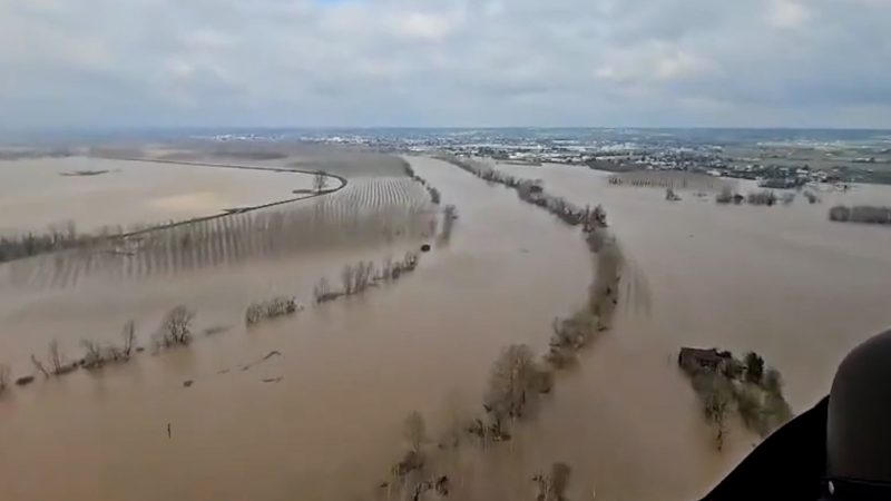
Life-threatening flash flooding may develop
While thunderstorms often produce brief downpours, the likelihood of heavy rain with storms into next week exists over a broad area. Rainfall from each storm can easily be enough to trigger urban and small stream flash flooding.
The storm from Wednesday morning to Thursday morning produced a general 1-3 inches of rain from the central Gulf coast to southern Virginia. However, a pocket where 3-4 inches of rain was more common occurred from southwestern Alabama to northern Georgia.
More heavy rainfall will be unleashed as the next storm rolls across the South Central and Southeast states this weekend.

The rain from the weekend storm, by itself and especially where it overlaps with the prior storm in portions of the lower Mississippi and Tennessee valleys and the southern Appalachians, may lead to flash flooding in urban areas and along small streams and escalate to some of the secondary rivers where there is no flood mitigation from levees or dams.
The storm this weekend is forecast to unload a broad area of 1-2 inches of rain in the East. However, a sizable zone from the mid-Mississippi Valley to the Ohio Valley may end up with 4-8 inches of rain with an AccuWeather Local StormMax™ of 13 inches.
Even though the bull's-eye of the rain from the weekend storm may be in a different zone when compared to the storm from Wednesday to Thursday, the combined rainfall from the storms since the start of the week could reach between 15 and 20 in some areas, so the ground will become saturated, and runoff can be excessive.

Some rivers may take a few extra days to respond to the runoff, and subsequent river flooding may extend well into next week.
People living in unprotected areas along small streams and rivers prone to flooding should be prepared to move to higher ground. Rising water may block some roads, and officials may need to take preventative flood control measures in some communities.
"The risk of flooding may also extend into portions of the Ohio Valley, central Appalachians and the mid-Atlantic, where rain combines with melting snow and ice jams on area streams and rivers," AccuWeather Meteorologist Brandon Buckingham said.
One more round of rain, severe weather next week?
The track and intensity of a storm for the middle part of next week are still being assessed at this time. Should the storm track inland over the Southeast states, another round of severe weather may unfold. However, a zone of drenching rain and localized flooding is possible just north of the storm track.
Want next-level safety, ad-free? Unlock advanced, hyperlocal severe weather alerts when you subscribe to Premium+ on the AccuWeather app. AccuWeather Alerts™ are prompted by our expert meteorologists who monitor and analyze dangerous weather risks 24/7 to keep you and your family safer.
Report a Typo


