Cooler air, severe storms highlight this week’s weather forecast in Northeast
A southward dip in the jet stream will bring cooler weather and the risk of severe storms to parts of the Northeast this week.
Another wave of cooler air is already spreading across the Northeast, but unlike the bone-dry and smoky conditions that were observed in many areas last week, the pattern this week has some rain and severe thunderstorms in the offing, AccuWeather meteorologists say.
Last week, a large southward dip in the jet stream associated with a storm at the same high level of the atmosphere was positioned near the Maine coast. The circulation around the storm not only funneled in dry, cool air across the Northeast but also vast amounts of smoke from ongoing wildfires in the Canadian provinces of Quebec and Ontario. That smoke made its way down to the ground and resulted in some of the worst air quality in decades in the Northeast.
Severe storms to eye part of I-95 corridor in Northeast
This week is bringing a new southward dip in the jet stream and another storm at the same level of the atmosphere. However, the position of that storm is key, and there is some moisture available as well. The center of the storm was located over the Great Lakes region Tuesday. As this storm drifts along, it will take a much more southern track compared to last week's storm.

"Winds from this week's storm will push smoke across the Great Lakes region and not across much of the Northeast most days," AccuWeather Senior Meteorologist Brett Anderson said. "That will mean much better air quality overall. But, sometimes, when the sun is out, high-flying smoke may cause the sky overhead to appear hazy."
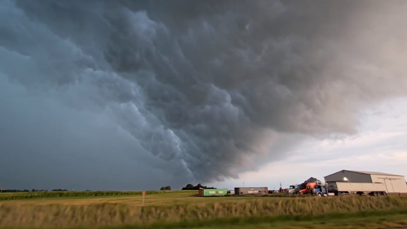
The same storm system will produce a round of severe thunderstorms as the leading edge of the chilliest air aloft advances eastward.
Areas from eastern Pennsylvania and much of New Jersey, eastern New York and southwestern and central New England will be at risk of the strongest storms.
"Under the strong June sun during the late morning on Wednesday, rising warm air will race upward and cause clouds to rapidly build through the afternoon, growing into heavy showers and severe thunderstorms," Anderson said.

Flash flooding in urban areas could occur thanks to slow-moving downpours, while some of the strongest storms will produce damaging wind gusts, hail that could cover the ground and frequent lightning strikes, according to Anderson.
Forecasters say people in the Interstate 95 corridor from near Philadelphia to New York City, as well as the Hudson Valley and Long Island regions of New York, the Berkshires and Connecticut Valley of New England and the western suburbs of Boston, should be aware of changing weather conditions if outdoors or on the road.
Travelers flying into or out of cities such as Philadelphia, New York City, Boston and Newark, New Jersey, could encounter flight delays due to the threat of storms.

As the storms and downpours roll in, temperatures may drop 10-20 degrees Fahrenheit in a few minutes after being in the 70s when the sun was out, Anderson said.
The same storm unleashed soaking rain in the central and northern Appalachians on Wednesday and will continue in some areas into Wednesday night. The rain was following downpours that soaked areas from the Midwest to the Northeast at the start of this week which helped to ease building drought conditions. The additional rain will bring anywhere from a few tenths of an inch to 2 inches or more in the wettest spots.
Yet another storm looms
As the first storm exits the Northeast Thursday and gives way to some sunshine and a brief warmup along much of the I-95 corridor, another storm and pocket of chilly air from the Great Lakes will eye the region.
"This new storm and chilly air will cause showers and gusty thunderstorms to erupt from lower Michigan through Ohio and western New York Thursday afternoon and evening," Anderson said.

This second storm will likely stall out over the Northeast from Friday to Saturday, leading to additional rounds of showers — and perhaps gusty thunderstorms — along with considerable clouds and unseasonably cool conditions from the Appalachians to near the Atlantic coast.
"Except for a few hours here and there into Saturday, this is certainly not the type of weather for hanging out at the pool or going to the beach, but at least the gardens, lawns and crops in the fields will appreciate the moisture," Anderson said.
Slightly warmer and drier conditions are expected for the second half of the weekend as high pressure builds in from Canada.
There may be some southward transfer of smoke and haze from the fires in Quebec into parts of the Northeast starting late this week and continuing this weekend. There is the possibility of some poor air quality conditions redeveloping, but perhaps not to the historical extent and magnitude of last week.


Want next-level safety, ad-free? Unlock advanced, hyperlocal severe weather alerts when you subscribe to Premium+ on the AccuWeather app. AccuWeather Alerts™ are prompted by our expert meteorologists who monitor and analyze dangerous weather risks 24/7 to keep you and your family safer.
Report a Typo