2nd atmospheric river to flood California with firehose of rain into Christmas
Heavy rain and flooding problems experienced in the Northwest in recent weeks from atmospheric rivers will shift farther south into California through Christmas Day with major travel disruptions and safety concerns.
Water rescue teams worked through rising floodwaters in Bayside and Freshwater, Humboldt County, on Dec. 21, helping both people and pets while urging residents to use extreme caution if traveling.
A second atmospheric river will force copious amounts of Pacific moisture into California this week. Heavy rain with incidents of flooding, washouts and mudslides will expand over much of the state, leading to a significant risk to lives and property, as well as major travel disruptions. The Sierra Nevada will receive many feet of snow as freezing levels lower through the week.
The storm and its problems are hitting at a busy time, with many traveling short and long distances, running errands and planning outdoor activities.
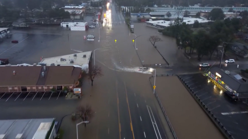
The first atmospheric river focused on Northern California from Sunday to Monday. This first round resulted in one fatality and multiple water rescues in Redding, California, located in the northern part of the state. During the 48-hour period ending Monday morning, some areas had received an excess of 6 inches of rain.

The zone of heavy rain with the first round will lift northward and dissipate Tuesday, leaving behind areas of drenching showers.
However, a second atmospheric river is forecast to develop and concentrate on much of California, including southern and central areas that were missed by the first round. The heaviest rain from this new plume of downpours will ramp up Tuesday night and continue Wednesday before easing Wednesday night and Christmas Day. But even beyond Christmas, lingering moisture will lead to additional rounds of showers and mountain snow, according to AccuWeather.
From Tuesday night to Friday, much of the Sacramento Valley and the San Francisco Bay region will receive 2-4 inches of rain with locally higher amounts. This will be on top of the rain that falls into Tuesday. The anticipated rainfall for San Francisco in the stormy pattern into this weekend will bring from one to two times the historical average for December.

On the west- and southwest-facing mountainsides of the Coast Ranges and the Sierra Nevada, with the new barrage, 4-12 inches of rain will pour down with an AccuWeather Local StormMax™ of 16 inches.
At times, multiple inches of rain can fall in a matter of hours, overwhelming storm drains and causing small streams and short rivers to quickly overflow their banks. As the ground becomes saturated, the risk of debris flows, road washouts and hillside collapses will increase substantially.
From Tuesday night to early Friday, the second atmospheric river will spray rain of varying intensity throughout Southern California.

A general 4-8 inches of rain is forecast to fall on the Los Angeles basin. Downtown L.A. had seven times its historical average monthly rainfall for November with 5.53 inches. While no rain has fallen in L.A. so far this month, a stormy pattern from Tuesday to Saturday may bring two to four times the average rainfall of 2.48 inches for December.
On the southwest-facing hillsides of the Transverse Ranges, 6-12 inches will pour down with an AccuWeather Local StormMax™ of 16 inches. Even in many desert areas of southeastern California, between 0.25 of an inch and 1 inch of rain is expected to fall.

Just as with the first atmospheric river that was largely confined to Northern California, rain will be drenching, leading to rapid urban flooding and flooding of small streams and short-run rivers, along with life-threatening mudslides, washouts and the potential for hillside slides in Southern California.
The combination of both atmospheric rivers and the showers that follow from Friday to Saturday may lead to 2 feet of rain in the wettest areas of the northern parts of the state.
Have the app? Unlock AccuWeather Alerts™ with Premium+
As the rounds of heavy rain and gusty winds affect San Francisco, Los Angeles, San Diego and dozens of secondary airports, expect airline delays and flight cancellations, which can have ripple effects on the airline industry nationwide as crews and aircraft are displaced, forcing rescheduling.

Storm may rapidly strengthen; strong winds are upcoming
"The storm providing the atmospheric rivers has the potential to become a bomb cyclone off the California coast," AccuWeather Meteorologist Brandon Buckingham said. "Regardless of whether the storm rapidly strengthens and experiences the required 24 millibars of pressure drop in 24 hours (0.71 of an inch of mercury), the storm will intensify enough to create strong winds along the coast of Northern and Central California."
Along with wind gusts frequenting 50-70 mph with higher gusts and an AccuWeather StormMax™ of 130 mph over the ridges and gaps in the mountains, heavy wave action will buffet the California coast. Overwash is possible along the Southern California beaches from the storm.

Winds this strong will lead to sporadic to regional power outages. Loose items around the property, such as Christmas decorations, could become dangerous projectiles or become damaged. The potential for high-profile vehicle rollovers increases in the presence of crosswinds.
Feet of snow may close roads in Sierra Nevada
Over the course of the week, the atmosphere will cool down to the point where snow levels will dip enough in the Sierra Nevada and the Siskiyous to allow heavy snow to fall at and below pass levels.
While up to a couple of inches of snow will fall at Donner Pass, California, along Interstate 80 through Tuesday as some warm air brings rounds of rain, rounds of heavy snow from Wednesday to Friday will bring 2-4 feet of snow, which can bring travel to a standstill.

"We're probably looking at at least 10 feet of snow this week over the ridges and peaks of the Sierra Nevada, which is what they need from an upcoming summer water demand standpoint," AccuWeather Chief On-Air Meteorologist Bernie Rayno said.
Ski resorts want plenty of natural snow on their slopes, especially during the industry's busy holiday season. However, so much snow may pile up that it could block roads to access the resorts located in the higher elevations.
Showers of rain, mountain snow to follow atmospheric rivers
Late this week and into the weekend between Christmas and New Year's, the rich supply of moisture will dwindle with the storm. However, enough will remain to produce rounds of showers throughout much of the state.
With colder air in place during that time, snow showers will continue to cause additional accumulations in the Sierra Nevada. Snow will also fall and accumulate over the mountains in Southern California, which could create slippery conditions on the passes along I-5 and I-15.

The same stormy pattern will continue to send periodic rain and mountain snow into Oregon and Washington, which have experienced heavy amounts of both in recent weeks. The ongoing moisture can aggravate small-stream river flooding problems at the local level.
The same pattern will also direct some moisture in the form of valley rain and mountain snow across the Intermountain West this weekend. Both have been lean thus far this season.


Want next-level safety, ad-free? Unlock advanced, hyperlocal severe weather alerts when you subscribe to Premium+ on the AccuWeather app. AccuWeather Alerts™ are prompted by our expert meteorologists who monitor and analyze dangerous weather risks 24/7 to keep you and your family safer.
Report a Typo