New Pacific storm, atmospheric river take aim at northwestern US, Northern California
By
Alex Sosnowski, AccuWeather senior meteorologist
Updated Feb 2, 2021 3:16 PM EDT
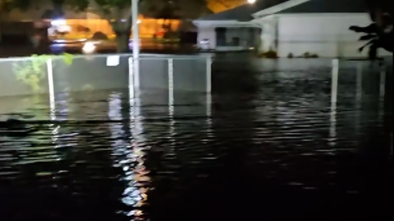
As roads became increasingly covered in water during heavy rain in Southern California on Jan. 29, one driver’s dashcam was recording as he hydroplaned and flipped. Two drivers behind him lost control in the same spot and slammed into him, but all are okay.
A new storm that arrived along the West Coast of the United States over the weekend may pale in comparison to its predecessor, but will still pack a punch. Instead of aiming for southern areas like a major storm last week, this one will focus its energy on the Northwest, including Northern California, through Tuesday.
"California was still reeling from the aftermath of a powerful storm that brought wind gusts of 125 mph, dropped more than 100 inches of snow on the Sierra Nevada and dumped over 15 inches of rain on parts of the state this past week," AccuWeather Meteorologist Ryan Adamson said.
The storm was pulling in some moisture from the Pacific Ocean in a weak atmospheric river and bringing rain and snow to portions of Oregon, Washington and Northern California during Monday night. Within bands of enhanced precipitation, drenching rain will pour down and snow will pile up over the mountains.
The areas of heavy rain and mountain snow are forecast to shift southward to a certain point, but not all the way through the Central Coast of California, unlike the monstrous storm that hammered that portion of the state, triggering mudslides, and burying the Sierra Nevada under feet of snow.
The latest storm is predicted to unleash total snowfall amounts on the order of 1-2 feet, with an AccuWeather Local StormMax™ of 3 feet for the Cascades through Tuesday and the northern part of the Sierra Nevada into Tuesday night. That accumulation will pile on top of the 6-10 feet of snow that fell on the Sierra Nevada during the slow-moving storm from the past week.
Snow levels are forecast to fluctuate with the storm. Near- to slightly above-freezing temperatures are forecast for the major passes of the Cascade and Siskiyou ranges at times. This will create some mixing with rain and wet, slushy road conditions at times.
Temperatures may also surge to or above freezing for a time at Donner Pass, California, but rounds of heavy snow are still forecast for this stretch of Interstate 80, which will slow travel over the pass and could yield a shutdown.
CLICK HERE FOR THE FREE ACCUWEATHER APP
Enough rain is forecast to fall to renew the risk of mudslides, but not only in Northern California as the storm progresses southeastward; drenching rain can be enough to loosen the soil and lead to slides along the steep slopes of coastal Washington and Oregon as well.
On Friday, a section of Highway 1 in California collapsed and was swept away as a result of torrential rain and erosion.
As a general 1-3 inches of rain is forecast from western Washington to Northern California over the lower elevations, 3-5 inches of rain can fall along the west- and southwest-facing slopes of the Coast Ranges, Cascades, Siskiyous and northern Sierra Nevada. An AccuWeather Local StormMax™ rainfall of 8 inches is anticipated.
Gusty winds accompanying the storm will not only raise the risk of sporadic power outages, but can create blizzard-like conditions at times over the high country.
The combination of gusty winds and fluctuating snow levels that create different layers of snow could substantially raise the avalanche risk. Skiers and snowmobilers are urged to avoid avalanche-prone areas as their action could initiate a major slide. On Saturday, an avalanche buried one or more people in Summit County, Utah.
"Although high winds are expected, gusts are not forecast to be nearly as strong with this storm as compared to its predecessor," Adamson said.
"However, the ground is still saturated in many locations and winds will not need to be very strong to topple trees, as the softened wet ground is less stable than dry ground," Adamson added.
By the middle of the week, the storm is forecast to lose intensity as it pivots inland.
The storm can still produce enough moisture to trigger low-elevation rain showers and mountain snow showers for the interior Southwest on Wednesday. At the very least, the showers can cause brief travel delays and hazards.
Two storms during the second half of January helped rainfall for the month trend close to average in Los Angeles. Following no measurable rain through Jan. 22, the storms brought 2.44 inches. The most recent storm unleashed 1.70 inches downtown. Normal rainfall for L.A. is about 3 inches in January, during what is considered the height of wet season for the region.
Farther north along the Pacific coast, San Francisco finished January at 70% of average with about 3 inches of rain compared to a normal of about 4 inches for the month. But, in Seattle, storms in January had delivered 8.72 inches of rain. The normal rainfall for Seattle in January is 5.57 inches. Rain is forecast to fall into the start of February on the Washington coast.
The latest indications suggest that the Pacific coast, especially California, will get a break from storms loaded with moisture beginning later this week. The lull in major storms could last for many days, forecasters say.
Keep checking back on AccuWeather.com and stay tuned to the AccuWeather Network on DirecTV, Frontier and Verizon Fios.
Report a Typo


News / Winter Weather
New Pacific storm, atmospheric river take aim at northwestern US, Northern California
By Alex Sosnowski, AccuWeather senior meteorologist
Updated Feb 2, 2021 3:16 PM EDT
As roads became increasingly covered in water during heavy rain in Southern California on Jan. 29, one driver’s dashcam was recording as he hydroplaned and flipped. Two drivers behind him lost control in the same spot and slammed into him, but all are okay.
A new storm that arrived along the West Coast of the United States over the weekend may pale in comparison to its predecessor, but will still pack a punch. Instead of aiming for southern areas like a major storm last week, this one will focus its energy on the Northwest, including Northern California, through Tuesday.
"California was still reeling from the aftermath of a powerful storm that brought wind gusts of 125 mph, dropped more than 100 inches of snow on the Sierra Nevada and dumped over 15 inches of rain on parts of the state this past week," AccuWeather Meteorologist Ryan Adamson said.
The storm was pulling in some moisture from the Pacific Ocean in a weak atmospheric river and bringing rain and snow to portions of Oregon, Washington and Northern California during Monday night. Within bands of enhanced precipitation, drenching rain will pour down and snow will pile up over the mountains.
The areas of heavy rain and mountain snow are forecast to shift southward to a certain point, but not all the way through the Central Coast of California, unlike the monstrous storm that hammered that portion of the state, triggering mudslides, and burying the Sierra Nevada under feet of snow.
The latest storm is predicted to unleash total snowfall amounts on the order of 1-2 feet, with an AccuWeather Local StormMax™ of 3 feet for the Cascades through Tuesday and the northern part of the Sierra Nevada into Tuesday night. That accumulation will pile on top of the 6-10 feet of snow that fell on the Sierra Nevada during the slow-moving storm from the past week.
Snow levels are forecast to fluctuate with the storm. Near- to slightly above-freezing temperatures are forecast for the major passes of the Cascade and Siskiyou ranges at times. This will create some mixing with rain and wet, slushy road conditions at times.
Temperatures may also surge to or above freezing for a time at Donner Pass, California, but rounds of heavy snow are still forecast for this stretch of Interstate 80, which will slow travel over the pass and could yield a shutdown.
CLICK HERE FOR THE FREE ACCUWEATHER APP
Enough rain is forecast to fall to renew the risk of mudslides, but not only in Northern California as the storm progresses southeastward; drenching rain can be enough to loosen the soil and lead to slides along the steep slopes of coastal Washington and Oregon as well.
On Friday, a section of Highway 1 in California collapsed and was swept away as a result of torrential rain and erosion.
As a general 1-3 inches of rain is forecast from western Washington to Northern California over the lower elevations, 3-5 inches of rain can fall along the west- and southwest-facing slopes of the Coast Ranges, Cascades, Siskiyous and northern Sierra Nevada. An AccuWeather Local StormMax™ rainfall of 8 inches is anticipated.
Gusty winds accompanying the storm will not only raise the risk of sporadic power outages, but can create blizzard-like conditions at times over the high country.
The combination of gusty winds and fluctuating snow levels that create different layers of snow could substantially raise the avalanche risk. Skiers and snowmobilers are urged to avoid avalanche-prone areas as their action could initiate a major slide. On Saturday, an avalanche buried one or more people in Summit County, Utah.
"Although high winds are expected, gusts are not forecast to be nearly as strong with this storm as compared to its predecessor," Adamson said.
"However, the ground is still saturated in many locations and winds will not need to be very strong to topple trees, as the softened wet ground is less stable than dry ground," Adamson added.
By the middle of the week, the storm is forecast to lose intensity as it pivots inland.
The storm can still produce enough moisture to trigger low-elevation rain showers and mountain snow showers for the interior Southwest on Wednesday. At the very least, the showers can cause brief travel delays and hazards.
Two storms during the second half of January helped rainfall for the month trend close to average in Los Angeles. Following no measurable rain through Jan. 22, the storms brought 2.44 inches. The most recent storm unleashed 1.70 inches downtown. Normal rainfall for L.A. is about 3 inches in January, during what is considered the height of wet season for the region.
Farther north along the Pacific coast, San Francisco finished January at 70% of average with about 3 inches of rain compared to a normal of about 4 inches for the month. But, in Seattle, storms in January had delivered 8.72 inches of rain. The normal rainfall for Seattle in January is 5.57 inches. Rain is forecast to fall into the start of February on the Washington coast.
The latest indications suggest that the Pacific coast, especially California, will get a break from storms loaded with moisture beginning later this week. The lull in major storms could last for many days, forecasters say.
Related:
Keep checking back on AccuWeather.com and stay tuned to the AccuWeather Network on DirecTV, Frontier and Verizon Fios.
Report a Typo