Rain and high-elevation snow to combat summer drought in western US this week
A storm system will sweep into the western United States with cool air, rain, high-elevation snow and gusty winds early next week.
By
Renee Duff, AccuWeather senior meteorologist
Published Sep 13, 2019 10:32 AM EDT
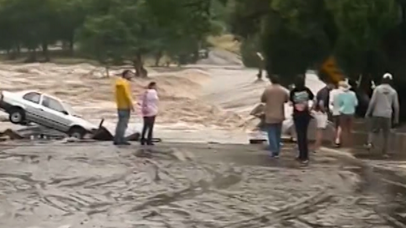
Heavy rain coated the ground in Salt Lake City, Utah, as storms blasted the region on Sept. 10. Nearby, in higher elevations, the storms produced snow.
A storm system will sweep into the western United States with cool air, rain, high-elevation snow and gusty winds early this week.
Within the span of a day or two, some residents will be swapping shorts for jackets and turning on heaters instead of air conditioners.
In what will be a roller-coaster ride, temperatures will tumble across the West early this week as a storm system moves ashore, according to AccuWeather Senior Meteorologist and western U.S. blogger Brian Thompson.
The jet stream will take a deep plunge across the West early this week. This southward plunge will allow cool air to funnel into the region.
"In some areas, the temperatures with this cooldown may even be a tad lower than the most recent round of cooler air," Thompson said.
High temperatures will be held to the 50s and 60s Fahrenheit across a broad area from the Pacific Northwest to the northern Rockies and Great Basin by Tuesday.
After reaching the lower 90s over the weekend, temperatures in Boise, Idaho, will fail to leave the 60s on Wednesday.
Across California's interior, highs in the 90s and 100s through the weekend will be replaced with 70s and 80s by Monday.
Rain and locally potent thunderstorms will sweep in along the leading edge of the cool push with western Washington and Oregon the first locations to be dampened on Sunday.
"Over a half inch of rain will fall in some areas, adding on to what has already been a wet start to September," Thompson said.
Seattle has already received more than double its normal month-to-date rainfall of 0.59 of an inch through the first 14 days of the month. The region could use the rainfall as abnormally dry to severe drought conditions persist from western Oregon through much of Washington, according to the latest outlook released by the U.S. Drought Monitor on Thursday.
Residents in San Francisco and Sacramento, California, will need to be pulling out umbrellas on Monday as the rain spreads farther south. This will likely be the first measurable rainfall (0.01 of an inch or greater) in either city since late May.
Since this region has been dry for months and oil has had a chance to build up on the roadways, sections of interstates 5 and 80 can be extra slick at the onset of rain.
"High-elevation snow will also be something to watch with this next system across the Cascades and northern Rockies," Thompson said.
Late-summer snow fell in parts of Montana, Wyoming and Utah earlier this past week during a plunge of cool air.
During the upcoming cooldown, snowflakes may again fly in these areas as well as over I-80's Donner Pass.
"The odds are against travel disruptions due to snow over the passes this early in the season," AccuWeather Senior Meteorologist Alex Sosnowski said. "However, it is possible that several inches of snow fall on non-paved areas at and above some of the passes."
People heading into the backcountry should make sure they have the proper gear to stay warm as the combination of the cool air and damp conditions will heighten the risk of hypothermia.
The bulk of the precipitation with this latest cool plunge will miss the Desert Southwest; however, Thompson anticipates a brief uptick in the monsoon across Arizona and the rest of the Four Corners region into Monday.
"Even if this materializes, it won't make up for the big rainfall deficits most areas are running this monsoon season," Thompson said.
However, there can be localized flash flooding in any heavier downpours.
Areas that do not get doused with any meaningful rainfall will face a heightened risk of wildfires and blowing dust due to locally gusty winds surging in along the leading edge of the cooldown.
"Crosswinds may be strong enough in open areas and through some of the passes to cause trouble for trucks, buses and motor homes," Sosnowski said.
Download the free AccuWeather app to stay alert to the forecast for your area. Keep checking back for updates on AccuWeather.com and stay tuned to the AccuWeather Network on DirecTV, Frontier and Verizon Fios.
Report a Typo


News / Weather News
Rain and high-elevation snow to combat summer drought in western US this week
A storm system will sweep into the western United States with cool air, rain, high-elevation snow and gusty winds early next week.
By Renee Duff, AccuWeather senior meteorologist
Published Sep 13, 2019 10:32 AM EDT
Heavy rain coated the ground in Salt Lake City, Utah, as storms blasted the region on Sept. 10. Nearby, in higher elevations, the storms produced snow.
A storm system will sweep into the western United States with cool air, rain, high-elevation snow and gusty winds early this week.
Within the span of a day or two, some residents will be swapping shorts for jackets and turning on heaters instead of air conditioners.
In what will be a roller-coaster ride, temperatures will tumble across the West early this week as a storm system moves ashore, according to AccuWeather Senior Meteorologist and western U.S. blogger Brian Thompson.
The jet stream will take a deep plunge across the West early this week. This southward plunge will allow cool air to funnel into the region.
"In some areas, the temperatures with this cooldown may even be a tad lower than the most recent round of cooler air," Thompson said.
High temperatures will be held to the 50s and 60s Fahrenheit across a broad area from the Pacific Northwest to the northern Rockies and Great Basin by Tuesday.
After reaching the lower 90s over the weekend, temperatures in Boise, Idaho, will fail to leave the 60s on Wednesday.
Across California's interior, highs in the 90s and 100s through the weekend will be replaced with 70s and 80s by Monday.
Rain and locally potent thunderstorms will sweep in along the leading edge of the cool push with western Washington and Oregon the first locations to be dampened on Sunday.
"Over a half inch of rain will fall in some areas, adding on to what has already been a wet start to September," Thompson said.
Seattle has already received more than double its normal month-to-date rainfall of 0.59 of an inch through the first 14 days of the month. The region could use the rainfall as abnormally dry to severe drought conditions persist from western Oregon through much of Washington, according to the latest outlook released by the U.S. Drought Monitor on Thursday.
Related:
Residents in San Francisco and Sacramento, California, will need to be pulling out umbrellas on Monday as the rain spreads farther south. This will likely be the first measurable rainfall (0.01 of an inch or greater) in either city since late May.
Since this region has been dry for months and oil has had a chance to build up on the roadways, sections of interstates 5 and 80 can be extra slick at the onset of rain.
"High-elevation snow will also be something to watch with this next system across the Cascades and northern Rockies," Thompson said.
Late-summer snow fell in parts of Montana, Wyoming and Utah earlier this past week during a plunge of cool air.
During the upcoming cooldown, snowflakes may again fly in these areas as well as over I-80's Donner Pass.
"The odds are against travel disruptions due to snow over the passes this early in the season," AccuWeather Senior Meteorologist Alex Sosnowski said. "However, it is possible that several inches of snow fall on non-paved areas at and above some of the passes."
People heading into the backcountry should make sure they have the proper gear to stay warm as the combination of the cool air and damp conditions will heighten the risk of hypothermia.
The bulk of the precipitation with this latest cool plunge will miss the Desert Southwest; however, Thompson anticipates a brief uptick in the monsoon across Arizona and the rest of the Four Corners region into Monday.
"Even if this materializes, it won't make up for the big rainfall deficits most areas are running this monsoon season," Thompson said.
However, there can be localized flash flooding in any heavier downpours.
Areas that do not get doused with any meaningful rainfall will face a heightened risk of wildfires and blowing dust due to locally gusty winds surging in along the leading edge of the cooldown.
"Crosswinds may be strong enough in open areas and through some of the passes to cause trouble for trucks, buses and motor homes," Sosnowski said.
Download the free AccuWeather app to stay alert to the forecast for your area. Keep checking back for updates on AccuWeather.com and stay tuned to the AccuWeather Network on DirecTV, Frontier and Verizon Fios.