Chilly blusters, snow showers to follow Friday potent northeast rainstorm
A powerful storm with high winds and heavy rain will lead to travel problems in the Northeast on Friday, before colder air sweeps in. Snow and lake-effect trail the storm from the Appalachians to Michigan.
A storm that led to near-zero visibility across parts of Minnesota and the Dakotas will have significant impacts for the Northeast and mid-Atlantic as well.
The same storm responsible for recent flooding in the Northwest and high winds in the northern Rockies will swing through the Northeastern states to round out the week. The storm will bring a surge of gusty winds and warmer air that favors rounds of torrential rain, followed by a quick drop in temperatures that will lead to snow and icy travel behind the storm in some areas from the Midwest to the Appalachians.
Temperatures ahead of the storm reached their highest levels in weeks in much of the Ohio Valley and Northeast Thursday. Just ahead of the storm's cold front, temperatures surged well into the 50s to near 60 in the mid-Atlantic and southeastern New England Friday morning.
Due to the storm's strength, combined with a warm air surge, heavy thunderstorms developed in portions of the Mississippi and Ohio valleys Thursday. Some people may notice thunder and lightning once the cold front associated with the storm system reaches the Appalachians and the Atlantic Seaboard Friday.
Rain from the storm will fall in multiple bursts of torrential, gusty downpours as it sweeps across the Northeast and parts of the Southeast.

Heavy rain falling on top of melting snow could lead to urban flooding, especially in areas where snow piles block storm drains. Stiff southerly winds ahead of the cold front will lead to minor to moderate flooding at times of high tide into Friday morning. The water levels are expected to receive a boost from the upcoming new moon and higher astronomical tides.
The corridor of downpours will focus on the Northeast's Interstate 95 zone early Friday, where motorists and airline passengers should expect substantial delays at that time.
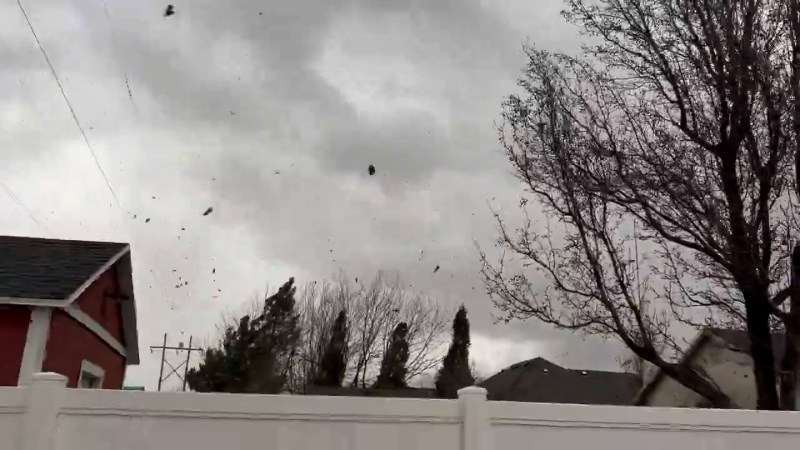
Gusty winds associated with the storm can be strong enough to cause airline delays.
"Along much of the mid-Atlantic I-95 zone, some of the strongest wind gusts will occur into the Friday morning rush hour, right as the storm's cold front approaches and swings through," AccuWeather Senior Meteorologist Dave Dombek said. In New England, the strongest winds from the south will occur from the late morning to the early afternoon on Friday.
Downed trees, branches and power outages could result at this time. Those with trash and recycling collection services Friday may need to secure their items and quickly retrieve their bins once emptied. Items such as trash cans can become dangerous and damaging projectiles during high-wind events.

On the back side of the storm, it will be a race between strong winds drying off roads and sidewalks versus leading to a quick freeze-up.
In Chicago, following a high in the low 50s Thursday, temperatures plummeted into the low teens and single digits Friday morning. Intermittent snow and a flash freeze were making the roads slippery in parts of the area. Some motorists may have trouble getting into their vehicles because the door is frozen shut.
From parts of Ohio and West Virginia to western Pennsylvania, upstate New York and northwestern New England, rain will mix with or change to accumulating snow Friday. A brief period of lake-effect snow will shift from Michigan to the shores of Lake Erie and Lake Ontario, as well as in the same Appalachian zones from West Virginia to upstate New York, from Friday to Friday night. It is in these aforementioned areas where roads will become slippery as temperatures plunge.

Looking ahead, a weak clipper storm will run along the northern tier of the Plains, Midwest and Northeast this weekend with a period of snow that may be locally enhanced by lake effect.
The storm and its snow will bring a new round of slippery travel from North Dakota and northern Minnesota to Michigan, upstate New York and northern New England. People traveling for their holiday ventures may encounter delays.

Temperatures in much of the Northeast will be lowered to near or slightly below historical averages by Saturday, but they are not forecast to be nearly as extreme as some recent episodes of cold air. Highs Saturday will range from near 30 in the northern tier to near 50 in southeastern Virginia.
AccuWeather meteorologists continue to look for ways for snow to fall around Christmas Eve and Christmas Day in the Midwest and Northeast. Yet another clipper storm is forecast to slice from west to east across the northern tier from Dec. 23 to Dec. 24. However, once again, snow may be limited to the northern tier.

Should that storm just prior to Christmas Day dip farther south, there is a chance that some snow or a wintry mix may extend more into portions of Pennsylvania, New Jersey, southeastern New York and southern New England by Christmas Eve. At this time, however, odds favor a period of rain instead of snow.


Want next-level safety, ad-free? Unlock advanced, hyperlocal severe weather alerts when you subscribe to Premium+ on the AccuWeather app. AccuWeather Alerts™ are prompted by our expert meteorologists who monitor and analyze dangerous weather risks 24/7 to keep you and your family safer.
Report a Typo