Go Back
  • For Business
  • |
  • Warnings
  • Data Suite
  • Forensics
  • Advertising
  • Superior Accuracy™
Which state leads the US in tornadoes this year? See the breakdown. Chevron right
Severe storms roll from Plains to Appalachians. Click for timing. Chevron right

Columbus, OH

86°F
Location Chevron down
Location News Videos
Use Current Location
Recent

Columbus

Ohio

86°
No results found.
Try searching for a city, zip code or point of interest.
Get Premium+
Create Your Account Unlock extended daily and hourly forecasts — all with your free account.
Let's Go Chevron right
Have an account already? Log In
settings
Help
Columbus, OH Weather
Today WinterCast Local {stormName} Tracker Hourly 10-Day Radar MinuteCast® Monthly Air Quality Health & Activities

Around the Globe

Hurricane Tracker

Severe Weather

Radar & Maps

News

News & Features

Astronomy

Business

Climate

Health

Recreation

Sports

Travel

For Business

Warnings

Data Suite

Forensics

Advertising

Superior Accuracy™

Video

Winter Center

Top Stories Severe Weather Hurricane Center Astronomy Heat Alert Climate Recreation Trending Today Health In Memoriam Case Studies Blogs & Webinars

News / Hurricane

Budding tropical disturbance to drench part of Caribbean

Tropical downpours will soak regions of the Caribbean during the first week of June, and AccuWeather meteorologists say that there is a slight chance that a tropical depression or storm takes shape.

By Alex Sosnowski, AccuWeather senior meteorologist

Published May 31, 2024 3:19 PM EDT | Updated Jun 4, 2024 3:14 AM EDT

Copied

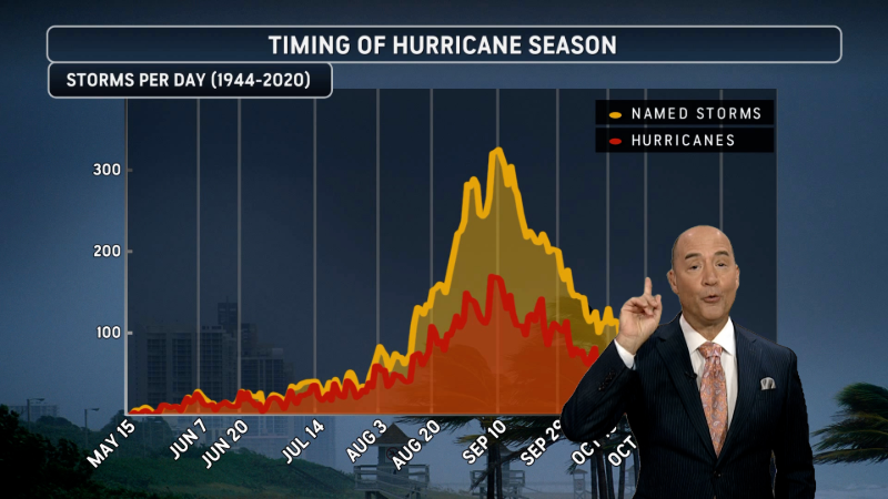
AccuWeather Long-Range Expert Joe Lundberg looks ahead to next week when more severe weather is expected and early tropical development is possible with hurricane season starting on June 1.

While the chance of tropical depression or storm formation is slim over the next week or so in the Atlantic basin, the chance is not zero and the brewing disturbance will produce an area of drenching rain and gusty thunderstorms over a portion of the Caribbean for a time during the first week of June.

AccuWeather meteorologists pointed out last week, and AccuWeather's Long-Range Team even earlier in May, that the area extends from the north-central Caribbean to part of the southwestern Atlantic east of the Bahamas and north of Puerto Rico.

The zone extends across an area with a weak tropical disturbance, combined with approaching energy from the Gulf of Mexico and proximity to an old front that has stalled in the region.

"While waters are warm enough in the region to support tropical development, along with these other positive factors, wind shear may be a deterrent for development," AccuWeather Lead Tropical Meteorologist Alex DaSilva said.

Water temperatures over much of the zone that AccuWeather has outlined are at or above 80 F and, in some cases, are running well above the historical average for early June. The minimum threshold for tropical development is 80 F.

Wind shear is associated with breezes that are often found in the tropics. When these breezes blow strongly in one direction or change directions at different heights above the sea surface, development may not occur, or an established tropical system could weaken.

GET THE FREE ACCUWEATHER APP

  •   Have the app? Unlock AccuWeather Alerts™ with Premium+

Regardless of any tropical development, this area of disturbed weather will result in an uptick in showers and thunderstorms through the end of this week from Jamaica to Haiti and the Dominican Republic, the Turks and Caicos, eastern Cuba and the southeastern Bahamas. It is possible that portions of Puerto Rico are also affected by downpours and locally gusty thunderstorms through Thursday.

Several inches of rain may pour down in a few hours, especially where mountainous terrain enhances rainfall. Where downpours persist, the risk of dangerous flash flooding will increase bringing the potential for mudslides. Seas and surf may get choppy in the vicinity of gusty thunderstorm activity.

"Because the system is likely to get scooped up by brisk steering winds, it should accelerate off to the northeast and away from the islands later this week," DaSilva said. "There will be no impact from this system on the United States mainland."

Largely because of abnormally warm ocean surface water and deep warm water, the zone from the western Caribbean to the Gulf of Mexico to the southwestern Atlantic, including along the southern Atlantic coast of the U.S., will remain an area to watch in the coming weeks. Many of these are considered "home brew" systems because of their proximity to North and Central America.

DaSilva and AccuWeather's staff of dozens of meteorologists are anticipating a super-charged hurricane season for 2024 and have been warning of the risks since late winter.

More to read:

Super-charged Atlantic hurricane season poised for intense activity
2024 Atlantic hurricanes are primed for 'rapid intensification'
2 hurricane names, including deadly Category 5, retired
2024 hurricane season names: Is your name on the list?

Want next-level safety, ad-free? Unlock advanced, hyperlocal severe weather alerts when you subscribe to Premium+ on the AccuWeather app. AccuWeather Alerts™ are prompted by our expert meteorologists who monitor and analyze dangerous weather risks 24/7 to keep you and your family safer.

Report a Typo
Weather News

video

Here's where we could see tropical development in the next two weeks

Jul. 31, 2026
Weather Forecasts

Heavy rain, flash flooding to sweep Midwest, Northeast

Jul. 31, 2026
Weather News

Rome’s multimillion-dollar cooling piazza shows the challenges of brut...

Jul. 31, 2026
Show more Show less Chevron down

Topics

Top Stories

Severe Weather

Hurricane Center

Astronomy

Heat Alert

Climate

Recreation

Trending Today

Health

In Memoriam

Case Studies

Blogs & Webinars

Top Stories

Severe Weather

Severe storms to march from Plains to Appalachians into Sunday

59 minutes ago

Weather Forecasts

Western heat dome fuels growing wildfire, flood threats

4 hours ago

Severe Weather

2026 tornado count: Illinois way up, Texas way down

1 hour ago

Astronomy

August night sky has a rare double feature with eclipse, meteor shower

9 hours ago

Severe Weather

Wisconsin EF3 tornado leaves damage as severe storms cut power

3 days ago

More Stories

Featured Stories

Recreation

Zion warns visitors of deadly flash flood danger during monsoon season

5 hours ago

Weather News

Sleeping giant: How sperm whales stay afloat while resting

5 hours ago

Weather News

Triple-digit heat fuels wildfires in France and Spain

2 days ago

Astronomy

Buck Moon 2026: July's full moon rises around the world

2 days ago

Climate

Mexico to unveil sargassum plan as crisis worsens in Caribbean

1 day ago

AccuWeather Hurricane Budding tropical disturbance to drench part of Caribbean
Company
Proven Superior Accuracy™ About AccuWeather Digital Advertising Careers Press Contact Us
Products & Services
For Business For Partners For Advertising AccuWeather APIs AccuWeather Connect Personal Weather Stations
Apps & Downloads
iPhone App Android App See all Apps & Downloads
Subscription Services
AccuWeather Premium AccuWeather Professional
More
AccuWeather Ready Business Health Hurricane Leisure and Recreation Severe Weather Space and Astronomy Sports Travel Weather News Winter Center
Company
Proven Superior Accuracy™ About AccuWeather Digital Advertising Careers Press Contact Us
Products & Services
For Business For Partners For Advertising AccuWeather APIs AccuWeather Connect Personal Weather Stations
Apps & Downloads
iPhone App Android App See all Apps & Downloads
Subscription Services
AccuWeather Premium AccuWeather Professional
More
AccuWeather Ready Business Health Hurricane Leisure and Recreation Severe Weather Space and Astronomy Sports Travel Weather News Winter Center
© 2026 AccuWeather, Inc. "AccuWeather" and sun design are registered trademarks of AccuWeather, Inc. All Rights Reserved.
Terms of Use | Privacy Policy | Cookie Policy | About Your Privacy Do Not Sell or Share My Personal Information | Data Sources

...

...

...