Go Back
  • For Business
  • |
  • Warnings
  • Data Suite
  • Forensics
  • Advertising
  • Superior Accuracy™
Over 100 million face wintry cold blast early next week. Get the forecast. Chevron right

Columbus, OH

54°F
Location Chevron down
Location News Videos
Use Current Location
Recent

Columbus

Ohio

54°
No results found.
Try searching for a city, zip code or point of interest.
settings
Columbus, OH Weather
Today WinterCast Local {stormName} Tracker Hourly Daily Radar MinuteCast® Monthly Air Quality Health & Activities

Around the Globe

Hurricane Tracker

Severe Weather

Radar & Maps

News

News & Features

Astronomy

Business

Climate

Health

Recreation

Sports

Travel

For Business

Warnings

Data Suite

Forensics

Advertising

Superior Accuracy™

Video

Winter Center

AccuWeather Early Hurricane Center Top Stories Trending Today Astronomy Heat Climate Health Recreation In Memoriam Case Studies Blogs & Webinars

Weather Blogs / WeatherMatrix

Hurricane Katrina at 10: New HD Storm Maps

By Jesse Ferrell, AccuWeather meteorologist and senior weather editor

Published Aug 24, 2015 2:16 PM EST

Copied

As I did for Hurricane Hugo's anniversary last year I'm proud to bring to you a set of freshly-drawn, HD television quality maps from Hurricane Katrina. Ten years ago (and especially during the whopper of a hurricane season in 2005) we didn't always take the time afterwards to look back and plot out the storm's intensity. Data was harder to come by too.

When choosing maps to draw in the "AccuWeather" format, I figured we had to do the overall track map, which we had - just had to update it - but also the big hitters that describe Hurricane Katrina's intensity: Wind, Storm Surge, Rain and Tornadoes. Thanks to Jeremy and Dan here at AccuWeather for making these maps a reality. Here's the track map:

AccuWeather

And some salient quotes:

AccuWeather

For wind, much research has been done over the years into Katrina's wind field. There were few maps that were detailed enough to make an attractive map, and in the end I went with this H*Wind map (NOAA sold their wind modeling software to a private company, H*Wind, after Hurricane Katrina). The crazy thing about this map: These are sustained winds, not including gusts. Specifically, H*Wind tells me they are "max 1 min sustained surface winds at 10 meters - marine exposure over water and open terrain over land."

AccuWeather

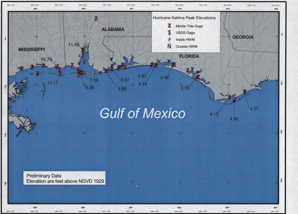
Storm surge was tough, and doesn't tell the story about the flooding in New Orleans because that was technically levee overtopping or breaching. It does, however, show the extent of the extreme damage on the Mississippi coast, which tends to be overlooked by the media who has trouble seeing past the New Orleans tragedy. The problem with storm surge is, other than point observations, you have to look at modeling to recreate what might have happened. I decided to go with this FEMA simulation, which we have redrawn here. This map shows values above 28 feet that are unconfirmed (officially, the storm surge maximum was 27.8 feet at Pass Christian, MS, with waves on top of that. Other unconfirmed reports include 33.4 feet (FEMA) and as high as 41.5 feet in Waveland, MS (Wikipedia).

AccuWeather

Rainfall was something that you don't hear a lot about in these Anniversary look-backs. Did you know Katrina brought more than a foot of rain at both landfall points, and that more than 7 inches fell into the mountains of North Carolina and Kentucky? Fortunately, NOAA WPC has a great set of historical maps for Tropical Storm and Hurricane rainfall. Their map for Katrina goes further north and east than ours does; I didn't want to shrink ours down too much. As noted on the map, Perrine, FL racked up 16.43" from the storm; there was 14.82" at Big Branch, LA.

AccuWeather

Another often-overlooked part of Katrina was the tornado outbreak. During the length of the storm, 60 tornadoes were reported (most, and their cities, are reflected in this graphic. Not shown on this map: tornadoes in Ohio, Virginia, Maryland and Pennsylvania, plus an EF-2 tornado in Monroe County, FL that caused $5 million in damage. There were five other EF-2 tornadoes in Mississippi and Georgia after the storm came on shore. I collected tornado info for August into a rough map that had non-Katrina tornadoes removed; original data was via the SPC and TornadoHistoryProject.com. I think our version of the map turned out to be pretty illustrative of the outbreak:

AccuWeather

And last but not least, let's not forget Florida. Hurricane Katrina killed 14 people and caused $623 million in damage, according to WikiPedia. We had a graphic on-hand for the effects there, before we became embroiled in the Louisiana aftermath and ran out of time. Here it is, redrawn in HD in our new format:

AccuWeather

Others have done even more amazing visualizations on the storm. Some images you might have not seen before:

Capital Weather Gang has some interesting Katrina maps I hadn't seen, including this interesting size comparison (wish it had Sandy):

The Huffington Post did an infographic comparing Superstorm Sandy (2012) with Hurricane Katrina, very interesting...

Huffpost

Below is a still from a visualization created by a team of researchers from the Advanced Visualization Laboratory (AVL) showing the dramatic evolution of Hurricane Katrina." There's also a related video on YouTube.

This 3-D view of the storm can be downloaded from NASA's Hurricane Katrina page:

All My Hurricane Katrina at 10 Blogs:

  • - Hurricane Katrina at 10: The Gas Price Rollercoaster

  • - Hurricane Katrina at 10: The Pets Infographic

  • - Hurricane Katrina at 10: The Lost JB Files

  • - Hurricane Katrina at 10: The Craziest Youtube Videos

  • - Hurricane Katrina at 10: The Media Coverage

  • - Hurricane Katrina at 10: 38below Blog Entries

  • - Hurricane Katrina at 10: Covering The Storm Live

  • - Hurricane Katrina at 10: New HD Storm Maps

  • - Hurricane Katrina at 10: Live-Tweeting the Storm Timeline

  • - Hurricane Katrina at 10: Dry Tortugas Stations Destroyed

  • - Hurricane Katrina at 10: Before and After Photos

600x281_08201422_remembering_katrina_news_stories_final
AccuWeather

Report a Typo

Weather News

video

Watching out for deer crossing roads this season

Nov. 7, 2025
video

Where's the snow? Winter off to a late start in Colorado

Nov. 7, 2025
video

Looking ahead to next week

Nov. 7, 2025
Show more Show less Chevron down

Topics

AccuWeather Early

Hurricane Center

Top Stories

Trending Today

Astronomy

Heat

Climate

Health

Recreation

In Memoriam

Case Studies

Blogs & Webinars

ABOUT THIS BLOG
WeatherMatrix
Jesse Ferrell
AccuWeather Meteorologist and Social Media Manager Jesse Ferrell covers extreme weather and the intersection of meteorology and social media.
  • Astronomy
    with Dave Samuhel
  • Canadian weather
    with Brett Anderson
  • Global climate change
    with Brett Anderson
  • Global weather
    with Jason Nicholls
  • Northeast US weather
    with Elliot Abrams
  • Plume Labs on Air Quality
    with Tyler Knowlton
  • RealImpact of weather
    with Dr. Joel N. Myers
  • WeatherMatrix
    with Jesse Ferrell
  • Western US weather
    with Brian Thompson

Featured Stories

Weather News

50 years later, remembering the wreck of the Edmund Fitzgerald

Recreation

A fleeting autumn illusion turns N.C. mountain into an 'animal'

1 day ago

Travel

Hundreds of US flights are getting slashed as the shutdown continues

1 day ago

Climate

Amazon lakes became ‘simmering basins’ as temperatures spiked

1 day ago

Climate

Antarctic glacier saw the fastest retreat in modern history

3 days ago

AccuWeather Weather Blogs Hurricane Katrina at 10: New HD Storm Maps
Company
Proven Superior Accuracy™ About AccuWeather Digital Advertising Careers Press Contact Us
Products & Services
For Business For Partners For Advertising AccuWeather APIs AccuWeather Connect RealFeel® and RealFeel Shade™ Personal Weather Stations
Apps & Downloads
iPhone App Android App See all Apps & Downloads
Subscription Services
AccuWeather Premium AccuWeather Professional
More
AccuWeather Ready Business Health Hurricane Leisure and Recreation Severe Weather Space and Astronomy Sports Travel Weather News Winter Center
© 2025 AccuWeather, Inc. "AccuWeather" and sun design are registered trademarks of AccuWeather, Inc. All Rights Reserved.
Terms of Use | Privacy Policy | Cookie Policy | About Your Privacy Do Not Sell or Share My Personal Information | Data Sources

...

...

...