Tornadoes, damaging wind and deadly floods leave trail of destruction across south-central US
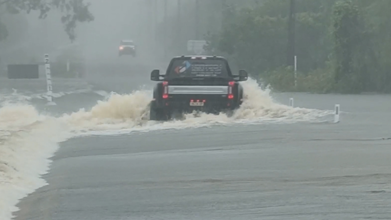
Portions of several roads, including the Kansas Turnpike, had to be shutdown in southern Kansas on May 7, after days of thunderstorms triggered flooding in the area. A drone captured footage of the flooding, which shows water racing over the roadways.
A powerful storm system is being blamed for at least one fatality after rattling parts of Texas, Oklahoma, Kansas, Arkansas and Louisiana with flooding, tornadoes and damaging hail this week.
When viewed on satellite Wednesday, the massive storm system appeared to be nearly half the size of Texas.
According to AccuWeather forecasters, the threat of tornadoes will subside on Thursday, but continued drenching rain will impact around 40 million Americans throughout Houston, Dallas, New Orleans, Memphis, Tennessee, and into Birmingham, Alabama.
Flooding from the storms turned deadly on Wednesday in Austin, officials said, after a man believed to be in his 50s was swept away by raging floodwaters. According to The Austin-American Statesman, officials from the Austin-Travis County Emergency Medical Services recovered the man's body after it was spotted in Lady Bird Lake. Authorities have yet to identify the man, but said his death was not believed to be suspicious.
At the height of the storm, more than 100,000 were without power. By Thursday about 37,000 in Texas were experiencing power outages along with about 31,000 who had power cut in Louisiana.
At least 17 preliminary tornadoes were reported on Tuesday. Law enforcement confirmed that a tornado moved from Howardwick to Alanreed, Texas, which is east of Amarillo. A dangerous situation unfolded on Tuesday evening as a large tornado tracked from near Hobart to Rocky, Oklahoma. This was confirmed by footage from nearby storm chasers when illuminated by lightning. Damage has been reported in the town of Rocky. National Weather Service (NWS) offices will conduct storm surveys over the coming days to confirm the number of tornadoes that touched down on Tuesday.
An additional four tornadoes were reported Wednesday. Two tornado reports were listed in Brazos County, Texas, while two others were reported in Louisiana, according to the Storm Prediction Center. A possible tornado destroyed a trailer home in Ruston, Louisiana, the site of last month's deadly tornado which claimed two lives. Near Saline, Louisiana, widespread damage was reported on social media from another possible tornado.
Extensive damage was reported to an apartment complex after severe storms rumbled through Pine Bluff, Arkansas, late Wednesday into early Thursday. At least 50 to 70 people were displaced, according to KARK. At least four people were injured. Pine Bluff Police Chief Kelvin Sergeant said a suspected tornado caused "extensive" damage to buildings, according to the Associated Press.
The Red Cross said it was working to assist those who were displaced by the storms.
Meanwhile, heavy rain inundated the Houston area through Tuesday evening. Residents took to social media to show their submerged cars after the storms unleashed flash flooding. Multiple social media users have reported flooded local streets. Flood watches and warnings were issued throughout the region and there were numerous reports of flooded roads and buildings. Drenching downpours over Texas on Tuesday triggered the spilling of more than 182,000 gallons of sewage out of the sanitary sewer system in Baytown, the Houston Chronicle reported.
The Houston Fire Department transported a woman in labor from a high-water rescue in the Kingwood area. Hundreds of homes were affected, according to a fire department spokesperson. Downpours from Tuesday night into Wednesday partially washed out at least one road in Kingwood, rendering it impassable. Hundreds of children in parts of Texas including Humble, New Caney and Cleveland were stuck at school on Tuesday - some of them overnight - due to floodwaters making it difficult for them to return home safely. In Fort Worth, Texas, emergency management officials performed several high-water rescues and closed off a number of roads as a result of the heavy rainfall inundating streets.
The National Weather Service said Tuesday that the flood gauge at Big Creek near Needville in Fort Bend County, Texas, actually crested higher (21.94 feet) than it did during Hurricane Harvey (21.71 feet) in 2017. AccuWeather Meteorologist and Social Media Manager Jesse Ferrell explained that intense rainfall rates fueled a phenomenon similar to the effects of Harvey with less than 20 percent of the total rainfall. “Research showed that, although Harvey dropped 35 inches of rain at the nearest rain gauge, it did so over a period of nine days, while yesterday’s 6.28 inches fell in only 12 hours, enabling a similar (and quicker) rise in the creek," Ferrell said.
Heavy rainfall across south-central Kansas on Tuesday night closed portions of Interstate 35 from south of Wichita to the Kansas/Oklahoma border, the Kansas Turnpike said. AccuWeather Extreme Meteorologist Reed Timmer was on the ground in the Texas Panhandle reporting on the storm activity on Tuesday. His drone footage captured a multiple vortex wedge tornado and circulation passing over Tulia, Texas, on Tuesday evening. The tornado lifted as it passed over the town. He spotted another tornado briefly touching down before drifting back into the clouds.
The powerful storms disrupted power lines in regions across Texas. During Tuesday evening, over 30,000 customers were without power throughout the state, PowerOutage.us reported. Airports in Houston and Dallas have reported delays and cancellations. Houston Bush International Airport reported over 550 delays on Tuesday. On Wednesday afternoon, 50 to 60 people were displaced in Pine Bluff, Arkansas, after a suspected tornado caused extensive damaged to an apartment complex, injuring at least four people, according to KARK-TV.
Severe weather across the south-central U.S. brought multiple strikes of lighting along with damaging winds and flash flooding, with over 200,000 lightning strikes across this region of the country over a 36-hour period.
Scroll down to view previous reports from the live storm coverage.
<hr>
9:40 p.m. CDT Wednesday:
The strongest thunderstorms are moving across parts of Mississippi, with strong to locally damaging winds the primary threat. This line should weaken into the overnight hours.

<hr>
8:30 p.m. CDT Wednesday:
KVOE reports there is a voluntary but recommended evacuation underway in Elmdale, Kansas, after water breached over-top a nearby dike in two locations.
<hr>
7:50 p.m. CDT Wednesday:
There are reports of emergency responders working to free people trapped inside an apartment following severe weather on Idaho Street in Pine Bluff, Arkansas.
<hr>
7:00 p.m. CDT Wednesday:
Heavy rain falling across portions of the middle and upper Mississippi Valley Wednesday will exacerbate ongoing flooding along the Mississippi and Missouri Rivers, where entire towns have already been inundated. This flooding will gradually translate downstream, with flooding along the lower Mississippi River potentially lasting into June.
Significant flooding is also likely in southeast Texas, where many rivers, such as the Trinity, Brazos and Sabine rivers are already above flood stage in many locations.
Additional heavy rain expected over the next few days will exacerbate the river flooding in the region, which will likely last into next week.
The severe storms are also packing damaging wind gusts, flash flooding, some hail, and lightning. There have been more than 200,000 lightning strikes across the south-central United States over the past 36 hours.

<hr>
6:00 p.m. CDT Wednesday:
There are large trees down and some minor structural damage from a line of storms with embedded tornadic circulations that passed through in Longview, Texas.
<hr>
5:30 p.m. CDT Wednesday:
A man was swept away in rising waters in downtown Austin this afternoon, and his body was recovered in Lady Bird Lake, KXAN reports.
Austin police reported seeing the man floating downstream under the South First Street Bridge.
<hr>
5:00 p.m. CDT Wednesday:
As of Wednesday afternoon, a line of ongoing storms and heavy rain stretches from western Arkansas into far northwest Louisiana and eastern Texas. This line of storms will continue moving eastward across Arkansas and Louisiana over the next few hours before dissipating this evening as it move into western Mississippi and western Tennessee.
These storms will bring the threat for damaging wind gusts and even a few tornadoes into early this evening. Some of the strongest storms can also bring some localized large hail.
A more isolated threat for severe thunderstorms will also exist the rest of this afternoon into tonight across south-central and southeastern Kansas and into Oklahoma, as another disturbance moving out of the Rockies crosses the region.
Some localized damaging wind gusts and hail will be the primary threats in this region.
<hr>
4:15 p.m. CDT Wednesday:
Wind damage has been reported across Longview, Texas following the severe weather. Downed trees and property damage are seen in the photos shared on social media below.
<hr>
3:35 p.m. CDT Wednesday:
AccuWeather Extreme Meteorologist Reed Timmer reports a dangerous line of storms with numerous tornado circulations in a Tornado Warned area including downtown Shreveport, Louisiana.
<hr>
2:30 p.m. CDT Wednesday:
College Station, Texas, is under a tornado warning, where a tornado recently touched down in College Station near Texas A&M on April 24.
<hr>
1:50 p.m. CDT Wednesday:
Severe flooding has caused Sumner County, Kansas, to declare a local state of disaster. Sumner County is located south of Wichita, Kansas.
<hr>
12:40 p.m. CDT Wednesday:
As heavy rains moved over southeastern Texas on Tuesday, over 182,000 gallons of sewage reportedly spilled out from the sanitary sewer system in the city of Baytown, Texas, according to the Houston Chronicle.
The overflow does not affect the city's fresh water supply, according to the Chronicle, citing city spokesperson Natasha Barrett.
<hr>
11:58 a.m. CDT Wednesday:
Officials with the Kansas Turnpike released aerial footage of the flooding from Slate Creek that has closed a stretch of Interstate 35.
Some of the heaviest rainfall totals have been located in the Wichita area.

<hr>
9:40 a.m. CDT Wednesday:
First responders in Fort Worth, Texas, are currently performing a number of high-water rescues in the southern part of the city, according to the Fort Worth Office of Emergency Management.
"The rain has made for very dangerous driving conditions," the Office tweeted. "Please turn around, don't drown and avoid all water on the roadways. Your safety is too important."
Weather conditions are also impacting air travel at Dallas/Fort Worth International Airport, where some arriving flights are delayed an average of two-and-a-half hours, according to the Federal Aviation Administration (FAA).
<hr>
9:15 a.m. CDT Wednesday:
Severe Thunderstorm Warnings issued by the National Weather Service (NWS) have been issued across parts of Texas, including Richland Springs, Democrat and Goldthwaite, through 10 a.m. CDT Wednesday. Meanwhile, more than 22,800 customers remain without power in the state, according to PowerOutage.us.

<hr>
7:45 a.m. CDT Wednesday:
Hamblen Road in Kingwood, Texas, was partially washed away across both lanes after severe weather and heavy rain impacted the area Tuesday and overnight. About 6.08 inches of rain fell in Luce Bayou on Wednesday, just to the east-northeast of Kingwood, according to AccuWeather Senior Meteorologist Paul Walker.
<hr>
6:38 a.m. CDT Wednesday:
On Wednesday morning, Big Creek, located near Needville, Texas, in Fort Bend County, crested higher than its levels during Hurricane Harvey in 2017, according to river gauge data from the National Weather Service.
Report a Typo