UK faces back-to-back storms as Josephine could help fuel a third
Austen and Boelo will bring strong winds and heavy rain through the weekend, with another possible windstorm linked to Josephine early next week.
Bernie Rayno breaks down when the storms will arrive and what their impacts will be.
Back-to-back storms Austen and Boelo will bring strong winds, heavy rain and flooding risks to the UK through the weekend, before Subtropical Storm Josephine could help fuel a third windstorm early next week.
AccuWeather International Forecast Expert Jason Nicholls said Storm Austen will affect the southern UK and northwestern Europe through Friday, followed by Storm Boelo across the UK and Ireland this weekend.

A man walks on the seafront promenade during the Austen storm in Saint Malo, western France on October 23, 2026. (Photo by Loic VENANCE / AFP via Getty Images)
Ahead of Boelo, Austen brought dangerous coastal conditions to Wales and southwestern England. Officials urged people to stay away from cliff edges and rough seas, where waves could sweep them off their feet. Wind warnings extend through Friday evening.
Austen has produced wind gusts up 76 mph at St. Mary's Airport in the Isles of Scilly, 74 mph in South Wales and 71 mph in Cornwall, according to the UK Met Office.
About 31,000 customers were without power on Friday across England with outages also reported in Wales, Northern Island and Scotland, according to poweroutage.com.
The UK Met Office named Boelo on Thursday. Its strongest winds are expected Saturday night into Sunday across Northern Ireland, Scotland and parts of northern England. Gusts were forecast to reach 70–80 mph along exposed coasts and over high ground, with gusts of 50–60 mph more widely.
Sand driven by Storm Austen’s strong winds covered a Welsh pizzeria, coating its windows and forcing the business to close on Oct. 23.
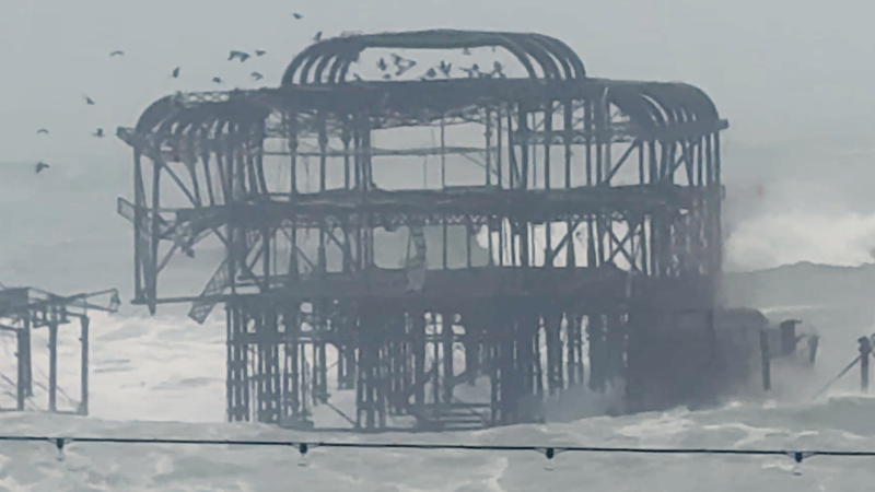
The wind and waves have been especially brutal in coastal areas where businesses closed in South Wales due to the storm, and part of the West Brighten Pier collapsed into the pounding surf.
According to the BBC, the pier first opened in 1866 and has been closed since 1975. Parts of the pier fell into the sea during a 2002 storm.

Pieces of the West Pier in Brighton falling off into the sea on Oct. 2026, as 31,000 homes have been left without power as Storm Austen sweeps across the South West, with further disruption expected across the weekend. (Photo by Jamie Lashmar/PA Images via Getty Images)
In southern and eastern Scotland, rainfall totals of 20-40 mm (about 0.8–1.6 inches) are expected within the rain warning area, with localized totals of 60-80 mm (2.4–3.1 inches). Flooding and travel disruptions are possible.

People stand on rocks as waves break near Portland Bill Lighthouse in Portland, southern England on October 23, 2026, as Storm Austen brought strong winds and heavy rain across much of southern England. (Photo by Henry Nicholls / AFP via Getty Images)
Austen is expected to move into the North Sea by Friday evening, allowing a brief break before Boelo arrives.
"As Boleo’s track is farther to the north, Scotland and northern portions of England and Ireland are likely to see higher winds than with Austen. Boleo will also bring strong winds and heavy rain to southern Norway," AccuWeather International Forecaster Lydia Burroughs said.
Back-to-back windstorms could be followed by a third early next week, potentially influenced by Subtropical Storm Josephine in the Atlantic.
"The windstorm linked to Josephine early next week is also expected to track to the north. If the storm tracks more toward the east, the western coasts of Ireland and Scotland could see wind gusts over 90 mph," Burroughs said.

Josephine was moving northeastward away from the United States Friday. The combination of the storm and strong high pressure to the north will produce gusty winds along coastal New England, including Cape Cod, as well as Nova Scotia and Newfoundland.
Chloe is the next available name on the storm list shared by the UK, Ireland and the Netherlands. However, an existing named Atlantic cyclone generally retains its name after crossing the ocean, so any naming decision would depend on how the system develops.
The Met Office names storms when their potential disruption or damage could warrant an amber or red weather warning, considering wind, rain or snow impacts.
Report a Typo