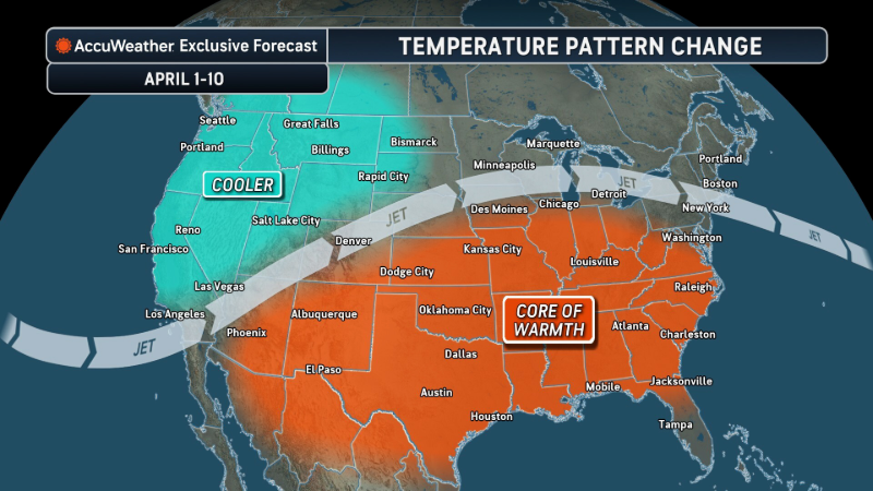
Bomb cyclone with atmospheric river blasts Oregon, Northern California and Washington
A storm packing inches of rain, feet of snow and damaging winds continue to affect areas from Oregon to Northern California and Washington as a combination atmospheric river and bomb cyclone take aim.
Conditions began to deteriorate in Northern California on the evening of Nov. 19 as an atmospheric river moved ashore in the Pacific Northwest.
A major storm will continue to pummel areas from Washington to Oregon and Northern California with torrential rain, heavy mountain snow and high winds this week, AccuWeather meteorologists warn.
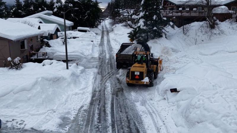
Due to low-elevation flooding, debris flows and blizzard conditions in the mountains, widespread travel impacts are expected while powerful gusts can knock down trees and power lines over a broad area.

The storm strengthened so fast that it fits into a special category of weather terminology known as a bomb cyclone. A storm, or cyclone, is essentially a giant spinning vacuum in the atmosphere. When a storm's central pressure drops 0.71 of an inch of mercury inches (24 millibars) or more in 24 hours or less, it is considered to be a bomb cyclone.
"This storm's central pressure crashed from 29.53 inches (1000 mb) to at least 27.82 inches (942 mb) in 24 hours, which is more than double the criteria for a bomb cyclone," AccuWeather Senior Meteorologist Heather Zehr said.
"The storm's fastest increase in strength was from Tuesday to Tuesday night, and correspondingly, that is when the strongest winds (50-70 mph) will be felt from the south along the immediate Pacific coast and from the southeast in and east of the Cascades and Siskyous," Zehr said.
The plunging atmospheric pressure in the center of the storm caused winds to increase with a vengeance. Close to 600,000 utility customers were without power in Washington due to the high winds taking down trees, tree limbs and power lines as of Wednesday morning.
Over water, a buoy off the coast of Vancouver Island recorded a gust of 101 mph Tuesday evening. Seattle-Tacoma International Airport gusted to 59 mph Tuesday night. Gusts of 53 mph were recorded at Eugene, Oregon.
Wednesday morning, as the central pressure of the cyclone rises, the wind gusts will come down. Eastern Oregon, the Klamath Mountains and northern Sierras can still gust to 55 mph Wednesday into Wednesday evening, but major population centers will get some relief from wind, at least. During Tuesday night, gusts of 71 mph were observed at Montague, California in Siskiyou County.
"Another major component of the storm will be a long plume of moisture directed at portions of the Pacific coast," AccuWeather Senior Meteorologist Brett Anderson said. That plume, known as an atmospheric river, will act like a massive firehose of rain at low elevations and a giant snow gun over the high country.
Snow levels will vary significantly during the storm--starting off at pass levels then rising above and falling back to pass levels in the Cascades, Siskyous and northern Sierra Nevada. Several inches to a foot of snow can fall over the passes in the Cascades on the front and backside of the storm. Where all snow falls over the high ground, a few feet can pile up. During much of the time when snow falls, strong wind gusts and snow can create blizzard conditions over the passes and high country.
From Into Wednesday, the atmospheric river will be mainly directed at the Northern California coast. In this area, from 8-12 inches of rain will fall from Tuesday to Friday with an AccuWeather Local StormMax™ rainfall of 20 inches.
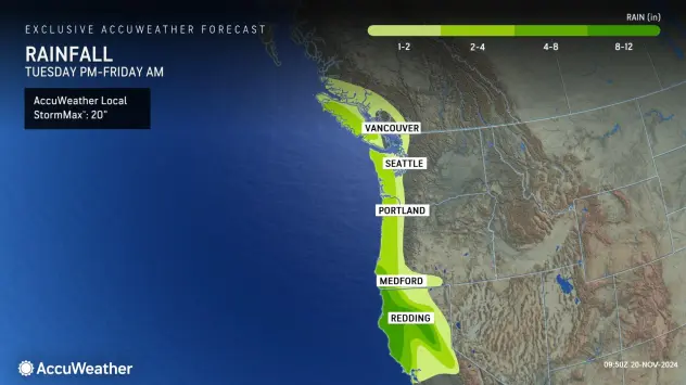
Western Washington will avoid the worst of the torrential rain, but widespread rainfall totals of 2-4 inches are likely.
Excessive precipitation can continue over parts of Northern California from Wednesday to Thursday.
"Soaking rain from the storm will reach the San Francisco Bay area but not until later in the week," Zehr said. "The heaviest rain will fall near and north of the North Bay and up along the coast of Northern California while San Francisco and the South Bay will be in the zone where rainfall will diminish quickly from north to south."

With only 0.22 of an inch of rain from a single storm so far this month and 0.26 of an inch of rain for November so far compared to a historical average of a little over 2 inches for all of the month, a thorough soaking is overdue. This storm has the potential to bring an inch of rain to San Francisco, which would bring the monthly tally back on track.
Where heavy rain eats into the freshly fallen heavy snow at intermediate elevations of the Siskyous and southern Cascades, a rapid meltdown can lead to life-threatening flash flooding, rapid debris flows and landslides.
Much of Southern California is still awaiting its first significant rain of the season. The last time there was enough rain to measure and create puddles in Los Angeles was on May 5, when 0.13 of an inch fell. Los Angeles typically receives 0.78 of an inch of rain during November.
Rain from the initial atmospheric river is forecast to avoid Los Angeles and Southern California, but there may finally be some downpours from a second and less intense storm that follows from the Pacific late this weekend to early next week. The early indications are that this next storm will track farther to the south and may become another bomb cyclone.


Want next-level safety, ad-free? Unlock advanced, hyperlocal severe weather alerts when you subscribe to Premium+ on the AccuWeather app. AccuWeather Alerts™ are prompted by our expert meteorologists who monitor and analyze dangerous weather risks 24/7 to keep you and your family safer.
Report a Typo