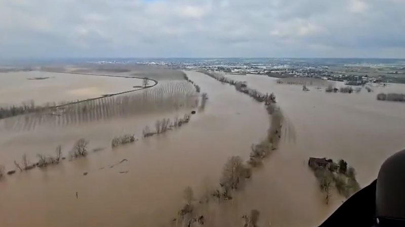
'Atmospheric river' will raise the risk of flooding in the Pacific Northwest into next week
The blows will keep on coming for the already saturated region, as two additional storms are predicted to unleash torrents of rain. Seattle and Portland will pick up the heaviest rain yet.
A storm barrage will continue to deliver heavy rain, escalating flooding concerns and causing disruptions to travel into next week.
Storms bringing rounds of rain and high elevation mountain snow will continue for a little longer, as AccuWeather meteorologists say yet another storm being carried ashore amid an "atmospheric river" will bring more heavy rain and gusty winds to the region early this week.
The rain, expected to add to the tally of several inches in rain gauges across portions of California, Oregon and Washington through Tuesday, could lead to a total amount of around a foot in some areas when factoring in what has already fallen since the past Wednesday. The repeated downpours can slow travel and cause flooding on streets and streams.
Combined with localized strong, gusty winds, the storms will no doubt ruin some outdoor plans, but the stormy forecast isn't all bad news. A long-standing and severe drought across western Oregon and Washington can rapidly improve in some areas thanks to the repeated rounds of rain.

No rest for the waterlogged, with two more storms expected
This past week, the first in a series of storms moved ashore in the Pacific Northwest from Wednesday into Thursday, as accurately predicted by AccuWeather. Rain, heavy at times, soaked the coast and the Interstate 5 corridor from northwestern California north to Washington, bringing 1 to locally 5 inches of rain, along with gusty winds.
The wet weather came after a nearly week-long break from precipitation in the region that followed the season's first significant snow in the mountains of the Cascades and northern Rockies. This time around, snow levels in the Cascades were very high—above pass levels—owing to the milder Pacific air moving in with the storm.
One more storm is on the way along the atmospheric river, a flow of deep atmospheric moisture off the Pacific that brings multiple rounds of heavy precipitation. The next storm will occur Sunday night through early Tuesday. Unlike the period between the first and second storms when it was primarily dry to end the week, showers can linger and bridge the gap between the storm that moved out of the area Saturday night and the next storm set to arrive late Sunday.

AccuWeather meteorologists warn that the rain amounts from the next storm can be even heavier than from the first, including in the major cities of Portland and Seattle.
The AccuWeather Local StormMax™ from the three storms over the course of six days is an astounding 15 inches. Rainfall of that magnitude, and even below it, would cause flooding issues.
"In some cases, enough rain may fall to lead to flash flooding of small streams, as well as mud and other debris flows," AccuWeather Senior Meteorologist Alex Sosnowski said. "Some of the short-run rivers that flow out of the Olympics and western slopes of the Cascades will rise significantly and swiftly."

Snow levels in the Cascades will remain very high for both storms, above the elevation where cars drive and most people reside.
A silver lining: Drought relief
Due to a lack of moisture-packed storms, parts of the Northwest have been dealing with drought conditions for months now. AccuWeather meteorologists believe that the storm train moving through the region can go a long way in helping to alleviate that drought into November.
"One of the effects of the storms will be to hack away at the drought that has been building in the region since early in the summer," said Sosnowski. "In some cases, that drought may be wiped out by the next Drought Monitor report that comes out next week, or the following update mid-month."
The U.S. Drought Monitor, the official interagency source for where drought conditions currently exist across the country, reported severe to extreme drought (levels 2-3 on a 4-point scale) over a large portion of the Northwest in their latest update released on Nov. 2. Drought of that magnitude was reported in nearly 36 percent of Washington nearly 19 percent of Oregon. Additionally, about 70-80 percent of land in both states was considered abnormally dry.

The most dire drought conditions were centered precisely in the areas expected to see the heaviest rain with the current atmospheric river event: the coast and the upsloping hills and mountains of the Olympic and Cascade ranges.
Beyond the current round of storminess, an extended dry period can return to the region for the middle and end of the new week, as the storm track is expected to shift offshore. However, it is not out of the question that by the end of this week and the upcoming weekend, a few of those storms can try to make it back on shore.
Want next-level safety, ad-free? Unlock advanced, hyperlocal severe weather alerts when you subscribe to Premium+ on the AccuWeather app. AccuWeather Alerts™ are prompted by our expert meteorologists who monitor and analyze dangerous weather risks 24/7 to keep you and your family safer.
Report a Typo


