Storms could slow US Thanksgiving travel on both coasts with rain East, rain and snow West
Heavy rain and gusty winds could slow Thanksgiving travel along the East coast this weekend into Monday. On Wednesday, heavy rain and mountain snow in the Northwest and downpours in the Southeast could cause more delays.
Feet of snow fell across mountains in California and Nevada from Nov. 18-19, causing major problems in Donner Pass and other areas.
The vast majority of weather-related travel disruptions heading into the Thanksgiving holiday will occur along the Eastern Seaboard and the West Coast states due to multiple storms, including major travel hubs ahead of one of the busiest times of the year for trips to see friends and family.
Those traveling at least 50 miles away from home by car, bus, train, airplane or cruise ship are estimated to be 81.5 million in the days surrounding Thanksgiving, according to the American Automobile Association.
Travel trouble spots this weekend

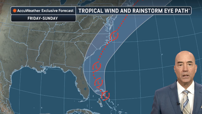
A tropical wind and rainstorm will affect the southern East Coast on Saturday before moving into the Northeast Sunday into Monday. Soaking rain will extend inland, but urban flooding and gusty winds are most likely to disrupt travel along parts of the Interstate 95 corridor and in coastal communities.
Flight delays are possible in the Northeast on Monday, with some cancellations also possible, including around New York City and Boston.

Even as heavy rain has departed the Florida Peninsula, lingering flooding and road closures will continue in the extensive St. Johns River watershed through the weekend after Thanksgiving.
A cold front will bring a narrow band of showers and thunderstorms from the Plains to the Mississippi Valley and Great Lakes this weekend. A few storms could turn severe, and brief downpours could reduce visibility for drivers.
Sunday looks like the most likely day for weather-related travel delays in Chicago over the next week, as rain showers could cause minor slowdowns.

In the wake of the front, pockets of snow showers and bands of lake-effect snow over the Great Lakes and interior Northeast could make for localized wintry travel and delays from Sunday to Tuesday.
A Pacific storm will bring rain to lower elevations and snow showers to the mountains from Northern California to Washington this weekend, although travel disruptions are expected to be minor. Any rain in Los Angeles should be brief.

Two main storms to watch for the week ahead
A strong Pacific storm is forecast to move into the Northwest Monday night and affect the region through Wednesday.
The storm is forecast to tap into an atmospheric river, a long band of concentrated moisture. Gusty winds, heavy rain at lower elevations and snow in the mountains from western Washington to Northern California could cause significant delays along Interstate 5 between Seattle and San Francisco. Mountain travel could also be affected on Interstate 80 and potentially Interstate 90.

Los Angeles and much of Southern California are expected to miss the heaviest rain from this storm.
A separate storm will bring rain and thunderstorms to parts of the Gulf Coast in the south-central United States Monday into Tuesday.

Wednesday could bring some of the most widespread weather-related travel disruptions ahead of Thanksgiving, particularly over the Southeast as the storm unleashes heavy rain and thunderstorms. Some storms could turn severe with powerful wind gusts.
Downpours could reduce visibility and create problems for motorists and airline passengers in the Atlanta and Charlotte areas on Wednesday, which is one of the busiest travel days of the year. Any flight delays or cancellations could have a ripple effect across the country.

More downpours could extend into the Florida Peninsula and potentially aggravate ongoing river flooding.
When the St. Johns River floods, it can last for months. AccuWeather’s Geoff Cornish explains why Florida’s longest river takes so long to drain. It has to do with a mixture of geography and weather.
The storm has the potential to pivot into the Northeast on Thanksgiving Day with mostly rain, threatening to dampen morning parades. If enough cold air moves in, rain could change to wet snow in parts of the interior Northeast, especially in the Appalachians and near the eastern Great Lakes.

Another storm could affect return travel in parts of the East and the Northwest during the weekend after Thanksgiving.
Moisture from Pacific storms will move inland, bringing periods of snow to parts of the interior West early next week and again later in the week. Snow could make some Rocky Mountain passes slippery at times.


Want next-level safety, ad-free? Unlock advanced, hyperlocal severe weather alerts when you subscribe to Premium+ on the AccuWeather app. AccuWeather Alerts™ are prompted by our expert meteorologists who monitor and analyze dangerous weather risks 24/7 to keep you and your family safer.
Report a Typo