East Coast storm duo to spread tropical rain, wind and flooding northward this weekend
A complex tropical wind and rainstorm will bring heavy rain, strong gusts and coastal flooding to parts of the East Coast from Florida to New England into early next week.
Two tropical rainstorms are developing near Florida and the Bahamas. See how their tracks could affect soaking rain and gusty winds along the East Coast this weekend, with 2-4 inches of rain forecast in some areas.
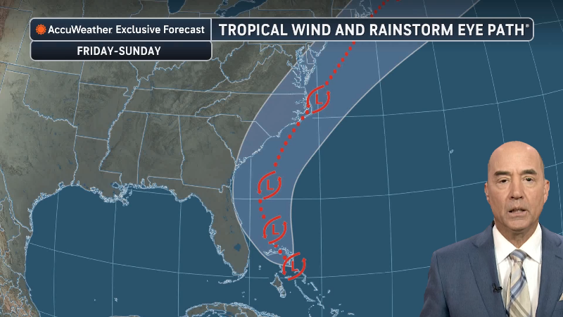
A complex tropical wind and rainstorm will focus on coastal areas of the southern Atlantic region this weekend and then progress to the Northeast later this weekend to early next week. Flooding downpours, some storm surge flooding and strong winds will all be in play with the storm duo along much of the Eastern Seaboard.
The storm duo will spur travel disruptions as some streets and highways take on water, while strong coastal winds raise the risk of localized power outages from Florida to Massachusetts and part of Atlantic Canada.

This image, captured on Friday, Nov. 20, 2026, shows two main clusters of thunderstorms. One batch is over northern Florida and the other is just east of the Bahamas. (AccuWeather Enhanced RealVue™ Satellite)
Either of the two storm centers has the potential to organize into a named tropical storm. However, with two competing centers of low pressure in the same area, the chances of tropical storm formation are lower than conceived earlier this week. The next names on the list are Kyle and Leah.
Regardless of whether one, two, or none of the storms acquire a name, the impacts will be the same with areas of torrential rain, above-normal tides and strong wind gusts in coastal locations; Hence AccuWeather's designation of a tropical wind and rainstorm to allow the public and officials to properly prepare and plan for adverse conditions.

The storm is rated a 1 on the AccuWeather RealImpact™ Scale for Hurricanes, which accounts for wind and impacts such as freshwater flooding, storm surge, beach erosion and economic losses. The Saffir-Simpson Hurricane Wind Scale uses a hurricane’s maximum sustained wind speed.

To keep the setup as simple as possible, AccuWeather will track both systems as one large storm system, since the two may eventually merge in the Northeast.
"One area of low pressure was forming along the northeast coast of Florida on Friday," AccuWeather Senior Meteorologist Brett Anderson said. "The storm will continue to produce heavy rain on northeast Florida, spreading into coastal Georgia through Friday night, and then into part of South Carolina Saturday to Saturday night."

Across northeastern Florida and southeastern Georgia, 4-8 inches of rain are forecast, with some locations receiving 8-12 inches.
The AccuWeather Local StormMax™ rainfall for the southern Atlantic Coast is 20 inches.

As rain falls over the northern portion of the St. Johns River in eastern Florida, water levels will rise in the coming days, compounding the major flooding already underway farther south in the river basin. In some areas, it may take months for the river to fall below flood stage, even if no more rain falls on the region, which is highly unlikely heading into the winter.
As the storm center moves north toward the Carolina coast this weekend, heavy rain could reach central parts of the Carolinas. The highest totals are expected near the coast, where 1-4 inches are forecast and some locations could receive 4-8 inches.

"A second area of low pressure is likely to form northeast of the Bahamas Friday night and track to the north-northwest this weekend," Anderson said. "This storm will tend to approach the upper mid-Atlantic coast later Sunday, then turn toward southern New England from Sunday night to early Monday."
The quick forward speed of this second storm will tend to limit the amount of rain, but rainfall rates could be heavy to excessive. "It may only rain for 6-8 hours from this northern part of the storm, but rainfall rates of 1-2 inches per hour are possible, which can overwhelm storm drains and lead to flash urban flooding." A general 1-4 inches of rain is forecast to fall from the upper mid-Atlantic to southeastern New England. The AccuWeather Local StormMax™ rainfall for New England is 11 inches.

"The storm forecast to develop farther out at sea has a higher chance of developing into a named storm as it will spend more time over water, compared to the storm near the Florida and Georgia coasts," Anderson said.
With the likelihood of two competing storm centers, the risk of a zone with hurricane-force wind gusts is substantially reduced. However, there will be a broad area with wind gusts of 40-60 mph along much of the coastal areas from North Carolina to Nova Scotia and Newfoundland.

Rain and gusty winds will also reach areas between the two forecast storm tracks. Localized flooding is possible from northeastern North Carolina through parts of Virginia, Maryland and Delaware, as well as in eastern Pennsylvania and southern New Jersey. Heavy rain could reach parts of Atlantic Canada early next week, raising the risk of localized flash flooding.
AccuWeather meteorologists forecast a storm surge of 1-3 feet along parts of the coast from northeastern Florida to New England. That means storm-driven water could rise 1-3 feet above the predicted tide, with minor to moderate coastal flooding possible around high tide. The AccuWeather Local StormMax™ storm surge is 5 feet.

"Renewed coastal flooding and beach erosion could force closures along North Carolina Highway 12 on Hatteras Island," AccuWeather Senior Meteorologist Alan Reppert said. "Parts of the Outer Banks have already experienced significant flooding and erosion this season."
Higher-than-usual high tides, often called king tides, are expected around the Tuesday, Nov. 24, full moon during Thanksgiving week. The timing and height of the tides will vary by location.

"With tides already running higher than usual, even a modest wind blowing toward shore could push enough water inland to flood low-lying areas from Long Island to eastern New England, especially around high tide early in the week," Anderson said.


Want next-level safety, ad-free? Unlock advanced, hyperlocal severe weather alerts when you subscribe to Premium+ on the AccuWeather app. AccuWeather Alerts™ are prompted by our expert meteorologists who monitor and analyze dangerous weather risks 24/7 to keep you and your family safer.
Report a Typo