First snows, wintry travel of the season upcoming for Midwest and Northeast
Winter coats and snow shovels may be needed across the Midwest and Northeast into early next week as the coldest air so far this season sets the stage for multiple rounds of snow.
In today’s Forecast Feed, AccuWeather’s Bernie Rayno takes a look at an upcoming stretch of December-like weather for the central and eastern United States.
The coldest air of the season so far is set to plunge into the Midwest and interior Northeast beginning this weekend, bringing rounds of snow and an early reminder of hazardous winter travel conditions. potentially coating some roads with slush and offering an early reminder of hazardous winter conditions.
From Saturday through early Tuesday, periods of snow could coat roads with slush and cause localized travel disruptions, especially during the overnight and early morning hours. This will be the first widespread wintry event for many areas.
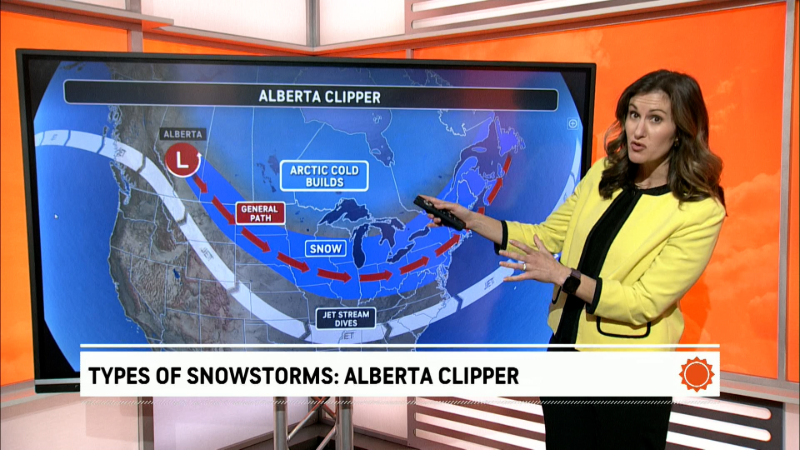
This cold spell is due to a significant shift in the jet stream expected by early next week.
Initially, an Alberta clipper is expected to move southeastward from Canada along the advancing cold air, producing a swath of accumulating snow from South Dakota to Michigan, southern Ontario and Quebec from Saturday to Sunday.

Snowfall accumulations will range from a small amount of slush on grassy surfaces, where snow is intermittent or mixed with rain for a time, to a few inches where snow falls heavily.
Little or no accumulation is expected along the Chicago lakefront and in downtown Detroit. However, in outlying areas where temperatures run slightly lower, untreated roads may become slippery. Should the snow fall heavier for a few hours at either location, widespread slippery conditions may unfold.

As the clipper storm turns the corner and shifts northward over eastern Canada, some of the heaviest snow of the pattern will fall on areas from central Ontario to southern Quebec. Snow accumulation may ramp up quickly just north of Toronto and Montreal, with several inches to a foot or more possible this weekend.
This clipper storm is not the only system expected to bring accumulating snow in the coming days.
As a big dip in the jet stream opens the door for cold air to expand across the Eastern states from Sunday night to Tuesday morning, the cold air passing over the warm waters of the Great Lakes will lead to lines of snow showers, known as lake-effect snow, that extend well inland.

Some precipitation may fall as a rain-snow mix or wet snow that melts on contact with the ground. However, where the bands of snow persist or extend across multiple lakes and become intense, a locally heavy snow accumulation can occur.
Several inches of snow are forecast to accumulate in northwestern Indiana and parts of Michigan's Upper Peninsula.

“Along with the bands of lake-effect snow is the potential for briefly heavy snow squalls in portions of Ohio, Pennsylvania, western and central New York and northern West Virginia on Monday,” AccuWeather Vice President of Forecast Operations Dan DePodwin said. “While most of the snow will melt quickly on area roads, the sudden drop in visibility and temporary slush can create dangerous conditions on the highways.”

Major multiple-vehicle pile-ups have occurred in the past under similar conditions with fast-moving snow squalls.
Even where snow does not accumulate, locally heavy snow showers may cause airline delays due to de-icing operations across the interior of the Northeast and the Upper Midwest.
No accumulating snow is forecast to reach the Interstate 95 corridor of the Northeast. However, there is a chance of a stray snow shower occurring in New York City, Philadelphia and Washington, D.C.
Snow showers may extend southward into the higher elevations of western Virginia, southern West Virginia, eastern Kentucky, eastern Tennessee, and western North Carolina this weekend, with a coating of snow possible.
The risk of lake-effect snow and sudden snow squalls is expected to diminish from late Monday night into Tuesday as the jet stream lifts and slightly warmer air moves in from the Plains to the Great Lakes.
Want next-level safety, ad-free? Unlock advanced, hyperlocal severe weather alerts when you subscribe to Premium+ on the AccuWeather app. AccuWeather Alerts™ are prompted by our expert meteorologists who monitor and analyze dangerous weather risks 24/7 to keep you and your family safer.
Report a Typo


