Isaias to sweep from central to northeastern US this weekend with soaking rain, gusty winds
While the greatest impacts from Isaias will be felt south of Interstate 20 in the southern US on Saturday, rain and wind will spread well inland over the Ohio Valley and Northeast this weekend.
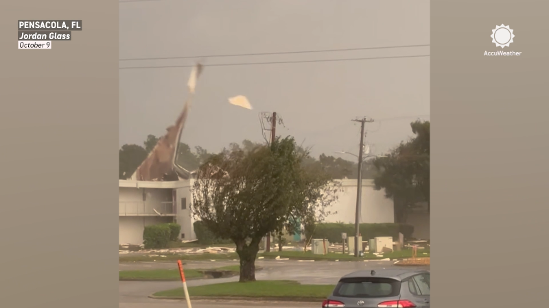
Debris was scattered across downtown Pensacola on the night of Oct. 9, even before Hurricane Isaias’ official landfall.
Isaias, as a tropical wind and rainstorm, will reach as far inland as the Ohio Valley before turning eastward, crossing the Appalachians in the Northeast later this weekend with areas of drenching downpours, strong gusts and flooding problems.

Isaias's winds could knock out power long after landfall
Fast movement of the storm will allow it to carry strong winds and drenching rain well inland over Alabama, western Georgia, eastern Mississippi and parts of Tennessee on Saturday.

As the storm continues to traverse the interior of the United States this weekend, the strongest winds will occur near and southeast of the storm center. Fast-moving tropical storms often bring their strongest winds to areas east of a northward-moving storm and south of an eastward-moving storm.
Severe thunderstorms and tornadoes will be a concern in the Southeast states this weekend.
The combination of the two factors will lead to a high risk of trees coming down, which can take out power lines with them.
As of daybreak Saturday, close to a million utility customers were without power in Florida, Georgia, and Alabama alone. During the midday, some power was restored near the Gulf, while outages increased farther inland with about 800,000 or so without power.

Wind gusts topping 40 mph north of Alabama can occur over much of Tennessee, southern Kentucky, the western parts of North Carolina and Virginia, the higher terrain of West Virginia, western Maryland and south-central Pennsylvania.

Another swath of gusty winds that can lead to sporadic power outages is likely along the immediate coastal areas of the southern and middle Atlantic regions.

The persistent nature of the winds from the southeast will lead to above-normal tides and minor to moderate coastal flooding at times of high tide from northeastern Florida to Virginia, Maryland, Delaware and perhaps part of New Jersey. Conditions should not be nearly as severe as with the long-duration nor'easter in late September.
The greatest risk of flash flooding from downpours, away from the Interstate 10 corridor along the central Gulf Coast and to portions of Interstate 20 in Alabama, will be along small streams, especially in hilly terrain. Widespread flash flooding is not expected. However, conditions at the local level could be serious.
From 1-4 inches of rain is forecast to fall from parts of the Ohio Valley to the mid-Atlantic coast, with pockets of 4-8 inches from northern Alabama to the Carolina coast.

Where rain pours down at an inch an hour or more, urban flash flooding can occur in some neighborhoods.

Rain, wind and timing for Isaias impacts in the Mid-Atlantic and Northeast.
Swift movement of the storm should prevent an excessive amount of water from flowing into large streams and rivers. However, there may be minor flooding along certain inland rivers in unprotected areas.

Rain, winds arrive in New England by Sunday
As Isaias, most likely a tropical wind and rainstorm, moves toward the coast in the Northeast states, downpours will spread to the mid-Atlantic and across southern New England during the second half of the weekend. This will follow a dry and pleasant autumn day on Saturday.

The storm, with its windswept rain, locally torrential downpours and power outage risk, will lead to travel delays as well.

The bulk of the airline delays will occur over the weekend, but some general travel delays will persist in the Northeast at the start of Monday. Those flying to Las Vegas, Phoenix, San Diego or Los Angeles this weekend may experience flight delays and cancellations due to Tropical Storm Rachel moving through the region with heavy rain, gusty winds and flooding.
In some cases, the rain and wind will knock off some of the color-changing foliage in the Northeast. In other cases, the weather could accelerate the leaf-changing process.

The best conditions for leaf viewing will be on Saturday, as conditions may deteriorate quickly on Sunday. Where leaves are coming down with the drenching rain, blocked storm drains can lead to street flooding.


Want next-level safety, ad-free? Unlock advanced, hyperlocal severe weather alerts when you subscribe to Premium+ on the AccuWeather app. AccuWeather Alerts™ are prompted by our expert meteorologists who monitor and analyze dangerous weather risks 24/7 to keep you and your family safer.
Report a Typo