Go Back
  • For Business
  • |
  • Warnings
  • Data Suite
  • Forensics
  • Advertising
  • Superior Accuracy™
Tropical Storm Gabrielle forms over the Atlantic. See the track forecast. Chevron right
Ash stirring up on Mount St. Helens, read more here. Chevron right

Columbus, OH

70°F
Location Chevron down
Location News Videos
Use Current Location
Recent

Columbus

Ohio

70°
No results found.
Try searching for a city, zip code or point of interest.
settings
Columbus, OH Weather
Today WinterCast Local {stormName} Tracker Hourly Daily Radar MinuteCast® Monthly Air Quality Health & Activities

Around the Globe

Hurricane Tracker

Severe Weather

Radar & Maps

News

News & Features

Astronomy

Business

Climate

Health

Recreation

Sports

Travel

For Business

Warnings

Data Suite

Forensics

Advertising

Superior Accuracy™

Video

Winter Center

AccuWeather Early Hurricane Center Top Stories Trending Today Astronomy Heat Climate Health Recreation In Memoriam Case Studies Blogs & Webinars

Weather Blogs / WeatherMatrix

Stats, Interesting Theories on Next Week`s Storm

By Jesse Ferrell, AccuWeather meteorologist and senior weather editor

Published Jan 31, 2009 10:23 AM EDT | Updated Jan 31, 2009 4:50 PM EDT

Copied

UPDATE 12 PM: We have some new videos up on the Breaking Weather News Page (PREMIUM | PRO), and it sounds like our meteorologists are favoring the low pressure going out over the water now, which could being moderate snow to the major cities, but not to the Ohio Valley. For some reason we seem to be having trouble posting our latest map in our Headlines; you can see it here on the Forums.

I implore you to remember my Rules For Comments previously published, or your Comments will not see the light of day, I just can't accept some of the nasty, inaccurate things that are showing up in the approval queue.

If you're going to post things that aren't true, I'm not going to accept them. I still have people accusing me of calling this storm a Superstorm today, for example, even though the word does not appear in this blog entry, even though the GFS is predicting a storm with the pressure of Cat 2 hurricane, and even though Joe Lundberg said this morning "there will be a powerful storm."

Remember, it's only the weather.

UPDATE: I just talked to Operations and we are crafting a new snowfall map to replace the one we put up yesterday morning. It will likely look closer to this map, and it will be out before noon. Stay tuned to our our Headlines (shown at right) and Breaking Weather News Page (PREMIUM | PRO), where we'll have more maps and videos today which explain our current thinking.

ORIGINAL POST: Here are some Saturday morning notes on next week's storm. We need to cut through the hype of the Forecast Models [JessePedia], the Media, my Blog Commenters, and the folks on the AccuWeather.com Forums. Some could be accused of "wishcasting" (hoping for snow in their area) and others for "bittercasting" (saying the storm is over when it's not). Here's the reality:

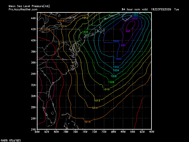
1. The storm had weakened on all models, but the GFS shows a Cat 2 Hurricane equivalent this morning.* 2. Henry believes the models are inaccurate because of the volcano and the eastward/weaker trend was false. 3. The current model consensus track takes it off the coast which could mean moderate snow for I-95. 4. The storm will probably still happen, but it could be too far east to get heavy snow, rain or winds on land.

*In regards to the weakening of the storm, here's what I said about the lowest Pressure from the models on Thursday:

DGEX: < 966 mb (Strong Cat 2 Hurricane Equivalent) GFS: < 968 mb (Cat 2 Hurricane) ECMWF: < 978 mb (Weak Cat 2 Hurricane) NOGAPS: < 982 mb (Cat 1 Hurricane) JMA: < 990 mb (Tropical Storm)

Here's an animation of the closest pass of the storm to Long Island, for the last 6 times the GFS has been run. Note that it moved the storm center out to sea and weakened it yesterday, but moved it back inland and strengthened it overnight.

This is what they are saying today:

DGEX: (Out of Range) GFS: < 976 mb NOGAPS: < 982 mb (NOTE: Is lower when in Canadian Maritimes) JMA: < 985 mb NMM (NEW!): < 994 mb (NOTE: May be lower further out) ECMWF: < 998mb (NOTE: May be lower inbetween hours)

The GFS is now the outlier on thinking the storm will be anything but a shadow of its former self. I am worried that the latest 12Z NMM (the preferred short-range model) shows a farily weak storm forming far offshore -- though admittedly it is at the end of its time frame. If we still want to see a strong storm near shore, then we'd better hope Henry is right and the models are nuts.

NOTICE: Due to time constraints, I cannot produce seasonal or point forecasts for every blog reader. Please access AccuWeather.com, especially AccuPOP, for a customized forecast from our team of mets, considering all options for your zipcode. Discuss all the upcoming storms on our Forums. Model images are from Pro.

What does all this mean for the track of the snow? Until we know where the storm's going and the models are more consistent, we won't know that for sure.

Report a Typo

Weather News

video

Severe storms slam the central US with pouring hail

Sep. 16, 2025
Weather Forecasts

Final days of summer to bring heat and drought in eastern, central US

Sep. 17, 2025
Weather News

Arizona woman swept away, killed in late-night flash flood

Sep. 15, 2025
Show more Show less Chevron down

Topics

AccuWeather Early

Hurricane Center

Top Stories

Trending Today

Astronomy

Heat

Climate

Health

Recreation

In Memoriam

Case Studies

Blogs & Webinars

ABOUT THIS BLOG
WeatherMatrix
Jesse Ferrell
AccuWeather Meteorologist and Social Media Manager Jesse Ferrell covers extreme weather and the intersection of meteorology and social media.
  • Astronomy
    with Dave Samuhel
  • Canadian weather
    with Brett Anderson
  • Global climate change
    with Brett Anderson
  • Global weather
    with Jason Nicholls
  • Northeast US weather
    with Elliot Abrams
  • Plume Labs on Air Quality
    with Tyler Knowlton
  • RealImpact of weather
    with Dr. Joel N. Myers
  • WeatherMatrix
    with Jesse Ferrell
  • Western US weather
    with Brian Thompson

Featured Stories

Live Blog

Does this radar loop show insects or birds?

LATEST ENTRY

Expert debunks claim about weird weather radar

1 day ago

Health

‘Kissing bug’ disease is here to stay in the US, experts say

1 day ago

Travel

Flying cars collide at airshow rehearsal in China

16 hours ago

Recreation

The motor festival that turns the desert into something like ‘Mad Max’

1 day ago

Weather News

Dinosaur eggs from China found to be around 86 million years old

2 days ago

AccuWeather Weather Blogs Stats, Interesting Theories on Next Week`s Storm
Company
Proven Superior Accuracy™ About AccuWeather Digital Advertising Careers Press Contact Us
Products & Services
For Business For Partners For Advertising AccuWeather APIs AccuWeather Connect RealFeel® and RealFeel Shade™ Personal Weather Stations
Apps & Downloads
iPhone App Android App See all Apps & Downloads
Subscription Services
AccuWeather Premium AccuWeather Professional
More
AccuWeather Ready Business Health Hurricane Leisure and Recreation Severe Weather Space and Astronomy Sports Travel Weather News Winter Center
© 2025 AccuWeather, Inc. "AccuWeather" and sun design are registered trademarks of AccuWeather, Inc. All Rights Reserved.
Terms of Use | Privacy Policy | Cookie Policy | About Your Privacy Do Not Sell or Share My Personal Information

...

...

...