Modern meteorology and eclipse chasing
This astronomy blog was written by Dr. Gordon Telepun, an expert eclipse photographer and eclipse educator with a special interest in the partial phase phenomena.
Since observing my first total solar eclipse in Zambia, Africa, in June of 2001, I feel that four major advancements have improved eclipse chasing:
1. DSLR cameras
2. Interactive internet-based eclipse maps
3. Improved weather satellites and prediction models
4. Mobile phone GPS geolocation
In 2001, I was shooting with ISO 200 slide film, observing positions were chosen from printed maps (Figure 1), weather satellite data was available but prediction models were not as advanced and mobile phones with GPS geolocation were not yet invented.

Figure 1. In the old days, eclipse observation site planning was done by ordering a hard copy of the NASA Eclipse Bulletin and looking at the local circumstances and the printed maps.
The 2019 Total Solar Eclipse
The July 2, 2019, total solar eclipse across South America provided an opportunity for me to fully appreciate the benefits of modern meteorology and mobile phone GPS geolocation and I want to share my experience with observing the eclipse in Argentina. The eclipse tour group I was with (Astro-Trails) was using San Juan, Argentina, as the staging city before eclipse day. On the morning of the eclipse, the plan was to board buses for a 100-mile ride northwest to the town of Bella Vista, Argentina, where 400 eclipse tour attendees would view the eclipse together from an alpaca farm called Posta Kamak.
Monitoring the weather before the eclipse
On the morning of July 1, about 40 hours before the eclipse, I was doing my best to monitor the South American satellite data from my hotel room in San Juan. Although the hotel had internet service, the bandwidth was low and it was impossible to download and view functioning satellite loops of the weather fronts.
Out of an entire set of satellite images that normally would loop, I could only manage to download and see 4 or 5 random still frames. But what I saw in these still frames worried me! There was a significant weather system north of two primary observing cities for this eclipse, my site in Bella Vista, Argentina, and another city in Chile where a lot of eclipse observers were headed, Vicuna. This system seemed to be generated from the coast and was impressively strong enough that the clouds were crossing the Andes Mountains and reaching the plains to the east. A weather system like this can ruin eclipse day! (Figure 2)

Figure 2. Just 40 hours before the eclipse an impressive weather system potentially threatens eclipse observing sites in Chile and Argentina (green circle). Models that predict weather system behavior and cloud predictions are important to eclipse chasing. (SJ-San Juan, BV-Bella Vista, VC- Vicuna)
The southernmost edge of this system was only about 130 miles northeast of Vicuna and about 140 miles north of Bella Vista.
The questions were: Where and what will this system be like in 40 hours? Which way is it moving? Is there a possibility of it getting stronger and enlarging? Without a function satellite loop in my hotel, I could not predict anything about this weather system!
What should I do?
In the 36 to 48 hours before an eclipse is when eclipse chasers monitor the final weather conditions of their primary observing site and make a final decision about where to observe. All veteran eclipse chasers, who generally stay mobile, will have pre-planned alternate observing sites in case of bad weather. This is the dilemma when observing an eclipse with a big tour group which is essentially obligated to go to their primary observing site since they are transporting 400 people to observe the eclipse. Big tour groups have very limited options to make an observing site change the day before the eclipse.
But I was considering my options the day before the eclipse. If the weather system I was concerned about had a chance of enlarging and moving south, should I NOT board the buses with my tour group and head to Bella Vista? I was thinking about an alternate plan to rent a car and stay just north of San Juan and perhaps go more east. This would have the trade-off of slightly less totality time and have the eclipse occur even lower on the horizon.
To paraphrase Fred Espenak, “it’s better to SEE a shorter totality than get clouded out of a longer totality.” So I was preparing to find an observing site on my own if necessary. (Figure 3)

Figure 3. The alternate plan of driving independently to an observing site would have the benefit of staying south and southeast of a potentially threatening weather system moving in from the north. But would make observing the eclipse even lower on the horizon.
Reaching out to Brian Lada for help
Since I knew AccuWeather Meteorologist Brian Lada after corresponding with him following the 2017 eclipse and working with him to write an AccuWeather blog before the 2019 eclipse, I reached out to him explaining my dilemma from San Juan. I sent him the best single frame satellite image I had and asked him if he would please look at the satellite loops that contained the weather system of concern and see what the cloud prediction models showed for this system for the next day.
After looking at the models he got back to me and reported that the system in question was predicted to stay north of my primary observing site in Bella Vista on eclipse day. (Figure 4) (Figure 5)
Feeling relieved with that updated information from Lada, I decided to go along with the tour group to Bella Vista on eclipse day. The weather models were correct and we had a perfectly clear day and a beautiful eclipse! (Figure 6)

Figure 4. The ECMWF cloud prediction model generated the day before the eclipse showed that the potentially problematic weather system was likely to stay north of the estimated path in Bella Vista on eclipse day (2PM and 8PM). This panel of images is compiled and labeled from the original data by Telepun
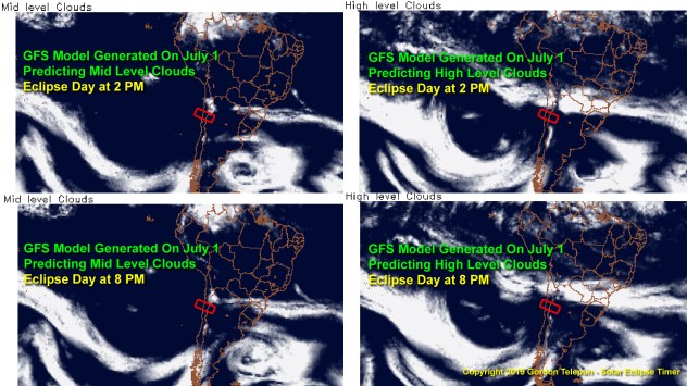
Figure 5. The GFS cloud prediction model generated the day before the eclipse showed that the potentially problematic weather system was likely to stay north of the estimated path in Bella Vista on eclipse day (2PM and 8PM). This panel of images is compiled and labeled from the original data by Telepun

Figure 6. The entire sequence of the total solar eclipse as it progresses along the ecliptic and sets into the Andes Mountains. Perfectly clear skies! This image is a composite of 17 partial phase images taken with a solar filter and a single totality image taken without a filter. The time gaps between the partial phase images where calculated by a function in the Solar Eclipse Timer app called the Partial Phase Image Sequence Calculator.
Mobile phones and GPS geolocation
Why was my last-minute alternate plan to head out on my own even possible? Because mobile phones can geolocate! The ability for anyone to find their exact GPS location is the basis for the functioning of my app Solar Eclipse Timer. My app uses the data set for an eclipse to calculate the precise contact times once the mobile phone has geolocated within the path of the eclipse. As long as you can use a basic map to get within the path, you can have your contact times calculated and the app will “talk” you through the eclipse.
Another crucial feature of Solar Eclipse Timer is that the eclipse data set and the contact time mathematical formula are within the app itself. So the app can function and calculate the contact times without cell service and an internet connection. So I knew that I could go out on my own, even in a desolate area of Argentina, and be able to time the eclipse precisely. Even though I ended up using the tour group’s observing site, the app helped because we played it through a Bluetooth speaker to help the observers in our immediate area enjoy the eclipse.
My friend Destin Sandlin, who has the YouTube channel Smarter Every Day, posted a video to his channel that demonstrates exactly what I am talking about. Because he had my app, which he also used in 2017, he knew he had the freedom to observe and time the 2019 eclipse anywhere in the path completely on his own. His entertaining video shows how he and his wife decided to get away from the eclipse crowds, and armed with my app, they set out to a desolate area in Argentina to enjoy the eclipse. You should watch this video and it can be found here.
Summary
Total solar eclipses are a wonderful thing to experience. Modern meteorology and new technologies have made eclipse planning more predictable and much less stressful.
I hope everyone will prepare to observe the next total solar eclipse in the United States on April 8, 2024. My Solar Eclipse Timer app already has the data set available for the 2024 eclipse.
Author bio
Dr. Gordon Telepun is a plastic surgeon who lives in Alabama. He is an expert eclipse photographer and eclipse educator with a special interest in the partial phase phenomena. He is the developer of the mobile app Solar Eclipse Timer which designed so he can be your personal guide and photography assistant through the stages of an eclipse. The app geolocates to calculate precise contact times of an eclipse. It does audible countdowns to the contact times and max eclipse, announces when to observe for various partial phase phenomena and automatically calculates the clock times needed to achieve a perfect eclipse sequence image.
Detailed eclipse educational videos can be found on his YouTube channel called Solar Eclipse Timer
Other eclipse information including details about the app is available on his website.
Report a Typo


