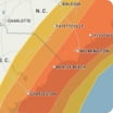
A storm later this weekend will shutdown travel and has the potential to be the biggest storm in years. Snow will overspread the Philadelphia area Saturday night and continue, heavy at times into early Monday. A total of 6-10 inches is forecast, but is highly dependent on the track and intensity of a coastal storm that forms and any mixing in of sleet and freezing rain. A more intense storm with little or no mixing in of sleet may result in higher total snowfall. Snowfall of a foot or more is anticipated well north and west of the city with amounts under 6 inches over southern New Jersey and central Delaware. Streets and highways will become rapidly covered with snow and are likely to be snow packed and slippery during much of the storm. Frigid air following the storm will result in little or no natural melting for a few days.
Wind Flow
This interactive map provides a visual representation of wind speed and direction over the next 24 hours

Maximum Sustained Winds
The projected maximum sustained winds of an active tropical system

Maximum Wind Gusts
The projected maximum wind gusts of an active tropical system


