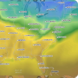
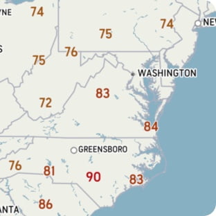
special weather statement in effect Mild temperatures, rainfall, and strong winds are expected. Locations: Newfoundland. Potential rainfall: 25 to 45 mm over southwestern Newfoundland with lesser amounts elsewhere. Potential wind gusts: southerly 70 to 90 km/h, except 110 or more along parts of the coast. Time span: overnight Friday night until Saturday afternoon. Remarks: An approaching trough of low pressure is expected to bring a period of unseasonably warm temperatures, rainfall, and strong winds to the island. Mild temperatures and rain may lead to significant snowmelt, runoff, and localized flooding. Gusty winds may cause tree branches to break and utility outages. Consider adjusting travel plans to avoid the most adverse conditions. Check ferry, transit, or flight schedules early, as disruptions may occur. Clear snow and ice away from storm drains and catch basins to help reduce localized flooding. Secure outdoor items that could be blown over by strong winds. ### Please continue to monitor alerts and forecasts issued by Environment Canada. To report severe weather, send an email to NLstorm@ec.gc.ca or post reports on X using #NLwx. For more information about the alerting program, please visit: https://www.canada.ca/en/services/environment/weather/severeweather/weather-alerts/colour-coded-alerts.