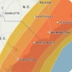
From Wednesday afternoon through Wednesday night, a period of accumulating snow will spread across the Chicago metro area and northern Indiana, leading to travel impacts, slowdowns and sharply reduced visibility in the heaviest bands east of the Illinois state line. Lake-effect snow can develop and bring concentrated bands to locations along the southern shores of Lake Michigan, resulting in a sharp gradient east of the city to northwestern Indiana. The highest totals are expected near La Porte County, Indiana, with 6-12 inches possible. Snowfall totals are generally expected to range from a coating to 1 inch around Chicago O’Hare International Airport and downtown Chicago.
Wind Flow
This interactive map provides a visual representation of wind speed and direction over the next 24 hours

Maximum Sustained Winds
The projected maximum sustained winds of an active tropical system

Maximum Wind Gusts
The projected maximum wind gusts of an active tropical system


